| Revision as of 18:35, 10 May 2010 editRenata (talk | contribs)Autopatrolled, Pending changes reviewers10,106 editsNo edit summary← Previous edit | Revision as of 19:00, 10 May 2010 edit undoRenata (talk | contribs)Autopatrolled, Pending changes reviewers10,106 editsNo edit summaryNext edit → | ||
| Line 23: | Line 23: | ||
| * | * | ||
| * | * | ||
| * | |||
| {{Borders-geo-stub}} | {{Borders-geo-stub}} | ||
Revision as of 19:00, 10 May 2010
| This article is an orphan, as no other articles link to it. Please introduce links to this page from related articles; try the Find link tool for suggestions. (February 2009) |

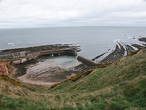
Cove is a village in the Scottish Borders area of Scotland, close to Cockburnspath, and between Dunbar and Eyemouth.
The natural harbour was improved in 1831 by the building of a breakwater. Access is via an unusual tunnel which was excavated using gunpowder.
Many fishermen lost their lives in the East Coast Fishing Disaster of 1881, and there is a memorial at the topf of the cliffs.
The village has been described by The AA Guide to the British Coast as having more of a Cornish than Scottish air about it. It has no school, shops or post office although it did before knocked down to build new holiday homes. There is a shop and post office nearby in the village of Cockburnspath which also has a school. Cove is privately owned by the architect Ben Tindall and the Cove Harbour Trust.
The Southern Upland Way passes through the Cove along the walk along the headland and the road in Cove.
See also
External links
- SCRAN image: Cove Harbour, Berwickshire
- RCAHMS/Canmore record for Cockburnspath railway station; Cove
- Gazetteer for Scotland: Cove Harbour
- Scottish Borders Council planning request
- GEOGRAPH image for Cove, Berwickshire
- Cockburnspath and Cove Community Council
This Scottish Borders location article is a stub. You can help Misplaced Pages by expanding it. |
55°56′13″N 2°21′08″W / 55.9369°N 2.3521°W / 55.9369; -2.3521
Categories: