| Revision as of 09:34, 7 July 2010 edit85.65.99.40 (talk) another picture of the park← Previous edit | Revision as of 05:44, 8 July 2010 edit undo85.65.99.40 (talk) →History: ce, + refNext edit → | ||
| Line 5: | Line 5: | ||
| ] | ] | ||
| In the ], Achziv was a town in the ], or plain country of Judah (Josh. 15:44); probably the same as |
In the ], Achziv was a town in the ], or plain country of Judah (Josh. 15:44); probably the same as Chezibh of Gen. 38:5 = Ain Kezbeh. It may have been a Phoenician city (the Gr. Ecdippa), though assigned to the tribe of ] (Josh. 19:29; Judg. 1:31) | ||
| "And the fifth lot came out for the tribe of the children of Asher ... and the outgoings thereof are at the sea from the coast to Achzibh".Achziv (Cheziv) is featured in Ancient Jewish Rabbinic writings, witness Midrash Vayikra Rabba 37:4 |
"And the fifth lot came out for the tribe of the children of Asher ... and the outgoings thereof are at the sea from the coast to Achzibh".Achziv (Cheziv) is featured in Ancient Jewish Rabbinic writings, witness Midrash Vayikra Rabba 37:4. ] added the city into his Kingdom, but ] returned it to ] as part of the famous pact. During Sancheriv invasions, the Assyrians conquered the city. During the reign of the Seleucids, the border was established at ], just north to Achziv, making it a border city and under the control of Acre. A maritime city named Cziv, nine miles north of Acre, is mentioned by ], and later by ]. During the ] period, the site was known as Casle Umberti.<ref>]]</ref> | ||
| Remnants of ancient Achziv, now known as Tel Achziv, are located on a sandstone mound between two creeks, Kziv creek on the north and Shaal creek on the south, close to the border with Lebanon. | |||
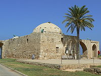
| The Arab village of ] was established during the Mamluk and Ottoman periods, the houses erected using the stones of the Crusader castle. The villagers fled to Lebanon during the ]. In 1946, the ] blew up the railroad bridge over the creek at Achziv in an operation known as ]. A monument to the 14 soldiers killed there was erected on the site. | |||
| ==Archaeology== | ==Archaeology== | ||
Revision as of 05:44, 8 July 2010

Achziv is an archaeological site on the northern coast of Israel, 15 kilometers north of Acre. Achziv is mentioned in the Bible as a biblical city given to the tribe of Asher. The Arab village of Az-Zeeb was established on the site during the Mamluk period. Today it is a national park.
History

In the Bible, Achziv was a town in the Shephelah, or plain country of Judah (Josh. 15:44); probably the same as Chezibh of Gen. 38:5 = Ain Kezbeh. It may have been a Phoenician city (the Gr. Ecdippa), though assigned to the tribe of Asher (Josh. 19:29; Judg. 1:31) "And the fifth lot came out for the tribe of the children of Asher ... and the outgoings thereof are at the sea from the coast to Achzibh".Achziv (Cheziv) is featured in Ancient Jewish Rabbinic writings, witness Midrash Vayikra Rabba 37:4. King David added the city into his Kingdom, but King Solomon returned it to Hiram as part of the famous pact. During Sancheriv invasions, the Assyrians conquered the city. During the reign of the Seleucids, the border was established at Rosh HaNikra, just north to Achziv, making it a border city and under the control of Acre. A maritime city named Cziv, nine miles north of Acre, is mentioned by Josephus Flavius, and later by Eusebius. During the Crusader period, the site was known as Casle Umberti.
Remnants of ancient Achziv, now known as Tel Achziv, are located on a sandstone mound between two creeks, Kziv creek on the north and Shaal creek on the south, close to the border with Lebanon.
The Arab village of Az-Zeeb was established during the Mamluk and Ottoman periods, the houses erected using the stones of the Crusader castle. The villagers fled to Lebanon during the 1948 Arab–Israeli War. In 1946, the The Jewish Resistance Movement blew up the railroad bridge over the creek at Achziv in an operation known as Night of the Bridges. A monument to the 14 soldiers killed there was erected on the site.
Archaeology

An ancient port was located on the coast, and another secondary port is located 700 m to the south. Archeological excavations have revealed that a walled city existed at the location from the Middle Bronze period. History of Achziv goes back to the Chalcolithic period (45-32C BC).
References
External links
- Achziv Achziv, by the Institute of Archaeology of the Hebrew University of Jerusalem, excavated under the direction of Dr. Eilat Mazar.
- Achziv archeological exhibit at the Hecht Museum Artifacts from the Cemetery at Achziv
33°03′N 35°06′E / 33.050°N 35.100°E / 33.050; 35.100
Categories: