| Revision as of 09:25, 28 May 2004 view sourceAmbarish (talk | contribs)Extended confirmed users1,528 edits Dharam Singh is new CM← Previous edit | Revision as of 04:20, 4 June 2004 view source Template namespace initialisation script (talk | contribs)5 editsNo edit summaryNext edit → | ||
| Line 69: | Line 69: | ||
| {{ |
{{India}} | ||
| ==External links== | ==External links== | ||
Revision as of 04:20, 4 June 2004

| |
| Date of formation | November 1, 1973 |
| Capital | Bangalore |
| Governor | T. N. Chaturvedi |
| Chief Minister | Dharam Singh |
| Area | 192,000 km2 |
| Population - Total - Density |
274.7/km² |
| Literacy rate: - Total - Male - Female | 58.36% 66.34% 50% |
| Urbanization: | 33.98% |
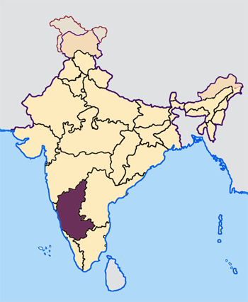
Karnataka is one of the four southern states of India. Bangalore, the capital city is the only city with a population of more than 1 million. Other major cities include Mysore, Mangalore, Hubli-Dharwad, Bellary and Belgaum. There are many noteworthy Hindu holy places in Karnataka, of which Udupi, Dharmasthala, Sringeri, Horanadu, Kollur are well known.
As of 2001, it is one of 10 Indian states with a population greater than 50 million. 90% of India's gold production comes from Karnataka.
It has Goa to its northwest, Maharashtra to its north, Andhra Pradesh to its east, Tamil Nadu to its east and southeast, and Kerala to its southwest. The western border is the shore of the Arabian Sea.
The state has three principal physical zones;
- The coastal strip, between the Western Ghats and the Arabian Sea, which is lowland, with moderate to high rainfall levels.
- The Western Ghats, a mountain range inland from the Arabian Sea, rising to about 900m average height, and with moderate to high rainfall levels.
- The Deccan Plateau, comprising the main inland region of the state, which is drier and verging on the semi-arid.
The districts of Karnataka are:
- Bagalkot
- Bangalore (Urban)
- Bangalore Rural District
- Belgaum
- Bellary
- Bidar
- Bijapur
- Chamrajnagar
- Chikmagalur
- Chitradurga
- Dakshina Kannada, also called South Canara
- Davangere
- Dharwad
- Gadag
- Gulbarga
- Hassan
- Haveri
- Kodagu, also called Coorg
- Kolar
- Koppal
- Mandya
- Mysore
- Raichur
- Shimoga
- Tumkur
- Udupi
- Uttara Kannada, also called North Kanara
There are several suggested etymologies for the name Karnataka. The most reasonable on is that it comes from "kari" + "nadu" meaning either "black country" or "elevated land". It is interesting to note that Karnataka has one of the highest average elevations of Indian states at 1500 feet.
Language
Due to the linguistic basis for the formation of the Indian states, language is a very important part of a state's identity. The predominant language of this area is Kannada, which is its official language. Other languages include Kodava Takk, Tulu and Konkani, as well as the languages of the surrounding states: Marathi, Telugu, Tamil and Malayalam.
History
The history of Karnataka can be traced back to the times of Ashoka. They were ruled by the Kadambas, the Gangas, the Chalukyas, the Hoysalas, the Vijayanagar kings, Tippu Sultan and Hyder Ali, the Wodeyars of Mysore and by the British over time.