| Revision as of 14:28, 20 January 2013 editMagioladitis (talk | contribs)Extended confirmed users, Rollbackers908,576 editsm Do clean up and general fixes using AWB (8857)← Previous edit | Revision as of 17:01, 20 January 2013 edit undoMagioladitis (talk | contribs)Extended confirmed users, Rollbackers908,576 editsm Remove unicode control characters (CHECKWIKI error 16) using AWB (8857)Next edit → | ||
| Line 4: | Line 4: | ||
| |name =In Aménas | |name =In Aménas | ||
| |official_name =Commune of In Aménas | |official_name =Commune of In Aménas | ||
| |native_name = |
|native_name =أمناس إن | ||
| |native_name_lang =ar<!-- ISO 639-2 code e.g. "fr" for French.--> | |native_name_lang =ar<!-- ISO 639-2 code e.g. "fr" for French.--> | ||
| |type =] | |type =] | ||
| Line 61: | Line 61: | ||
| }} | }} | ||
| '''In Aménas''' ({{Lang-ar| |
'''In Aménas''' ({{Lang-ar| أمناس إن}},<ref> in Official journals of the People's Democratic Republic of Algeria</ref> ''‘in ’amanās'' ) is a town and municipality in eastern ], bordering with ]. The town is located 30 km west of the border. There is no border crossing in the area. The municipality had 7 385 inhabitants in 2008.<ref> World Gazetteer, retrieved January 19, 2013</ref> The name is a ] word which means mountain top. | ||
| In Amenas is the starting point of the In Amenas-Haoud El Hamra oil pipeline and the In Amenas -Hassi Messaoud gas pipeline.<ref>{{cite web |url=http://theodora.com/pipelines/north_africa_oil_gas_products_pipelines_map.html |title=North Africa Pipelines map - Crude Oil (petroleum) pipelines - Natural Gas pipelines - Products pipelines |publisher=Theodora.com |accessdate=2013-01-19}}</ref> | In Amenas is the starting point of the In Amenas-Haoud El Hamra oil pipeline and the In Amenas -Hassi Messaoud gas pipeline.<ref>{{cite web |url=http://theodora.com/pipelines/north_africa_oil_gas_products_pipelines_map.html |title=North Africa Pipelines map - Crude Oil (petroleum) pipelines - Natural Gas pipelines - Products pipelines |publisher=Theodora.com |accessdate=2013-01-19}}</ref> | ||
Revision as of 17:01, 20 January 2013
For other uses, see Aménas. Municipality in Illizi, Algeria| In Aménas أمناس إن | |
|---|---|
| Municipality | |
| Commune of In Aménas | |
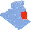
 Location of In Aménas within Illizi Province Location of In Aménas within Illizi Province | |
| Country | |
| Province | Illizi |
| District | In Amenas (seat) |
| Area | |
| • Total | 14,913 km (5,758 sq mi) |
| Population | |
| • Total | 7,385 |
| • Density | 0.50/km (1.3/sq mi) |
| Time zone | UTC+01 (CET) |
| Postal code | 33200 |
| ONS code | 3306 |
In Aménas (Template:Lang-ar, ‘in ’amanās ) is a town and municipality in eastern Algeria, bordering with Libya. The town is located 30 km west of the border. There is no border crossing in the area. The municipality had 7 385 inhabitants in 2008. The name is a tuareg languages word which means mountain top.
In Amenas is the starting point of the In Amenas-Haoud El Hamra oil pipeline and the In Amenas -Hassi Messaoud gas pipeline.
The natural gas joint development project (known as the In Amenas Gas Project) which includes four primary gas fields plus the gathering and processing facilities in Tiguentourine, 25 kilometres (16 mi) outside the town, was commissioned in 2006. The project is operated by Sonatrach, BP, and Statoil. Zarzaitine is one of the notable sites Sonatrach is operating in the area.
The natural gas facility near the municipality was attacked by Islamist militants on 16 January 2013.
Transport
It is served by In Aménas Airport with Air Algérie flights to Algiers, Hassi Messaoud, Oran and Ouargla and Tassili Airlines flights to Adrar, El Golea, El Oued, In Salah, Tébessa and Touggourt.
Geography
Climate
In Aménas has a hot subtropical desert climate (BWh, according to the Köppen climate classification). Summers are long and hot, and winters have mild days and chilly nights, with temperatures sometimes falling below 0 °C (32 °F).
| Climate data for In Aménas | |||||||||||||
|---|---|---|---|---|---|---|---|---|---|---|---|---|---|
| Month | Jan | Feb | Mar | Apr | May | Jun | Jul | Aug | Sep | Oct | Nov | Dec | Year |
| Mean daily maximum °C (°F) | 18 (64) |
21 (70) |
25 (77) |
30 (86) |
35 (95) |
39 (102) |
39 (102) |
39 (102) |
36 (97) |
30 (86) |
24 (75) |
18 (64) |
30 (85) |
| Mean daily minimum °C (°F) | 3 (37) |
5 (41) |
9 (48) |
14 (57) |
19 (66) |
23 (73) |
23 (73) |
22 (72) |
20 (68) |
16 (61) |
9 (48) |
4 (39) |
14 (57) |
| Average precipitation mm (inches) | 2.5 (0.10) |
1.5 (0.06) |
3.7 (0.15) |
1.2 (0.05) |
2.0 (0.08) |
1.3 (0.05) |
0.0 (0.0) |
0.5 (0.02) |
1.1 (0.04) |
3.7 (0.15) |
2.4 (0.09) |
3.3 (0.13) |
23.2 (0.92) |
| Source: Weather underground | |||||||||||||
References
- Wilaya of Ilizi in Official journals of the People's Democratic Republic of Algeria
- In Amenas World Gazetteer, retrieved January 19, 2013
- "North Africa Pipelines map - Crude Oil (petroleum) pipelines - Natural Gas pipelines - Products pipelines". Theodora.com. Retrieved 2013-01-19.
- Andrew Callus: "Desert site is home to kidnapped foreign gas workers" Reuters, 16 January 2013
- Maiken Ree for NTB: Statoil-anlegg angrepet i Algerie (in Norwegian) Teknisk Ukeblad, 16 January 2013
- New York Times report on In Aménas hostage crisis
- "Season weather averages". Weather Underground.
| Illizi District |  | ||||||
|---|---|---|---|---|---|---|---|
| Djanet District | |||||||
| In Amenas District | |||||||