| Revision as of 18:00, 27 February 2013 editJAnDbot (talk | contribs)Bots159,117 editsm r2.7.2) (Robot: Removing cs, de, eo, fr, hu, it, nl, pl, sk, war← Previous edit | Revision as of 15:23, 17 September 2013 edit undoYobot (talk | contribs)Bots4,733,870 editsm WP:CHECKWIKI error fixes / special characters in pagetitle using AWB (9485)Next edit → | ||
| Line 84: | Line 84: | ||
| ==History== | ==History== | ||
| In ] the village was first mentioned in 1326 or in 1549 . | In ] the village was first mentioned in 1326 or in 1549 . | ||
| ==Geography== | ==Geography== | ||
| The village lies at an altitude of 881 metres and covers an area of 55. |
The village lies at an altitude of 881 metres and covers an area of 55.974 km². It has population of about 1,531 people. The ] river rises in the cadastral area of the village, under the ] mountain. | ||
| ] | ] | ||
| Line 93: | Line 93: | ||
| {{Brezno District}} | {{Brezno District}} | ||
| {{DEFAULTSORT:Telgart}} | |||
| ⚫ | {{BanskáBystrica-geo-stub}} | ||
| ⚫ | ] | ||
| ⚫ | {{BanskáBystrica-geo-stub}} | ||
| ⚫ | ] | ||
Revision as of 15:23, 17 September 2013
Telgárt (called Švermovo in 1948–1990) is a village and municipality in Brezno District, in the Banská Bystrica Region of central Slovakia.
History
In historical records the village was first mentioned in 1326 or in 1549 .
Geography
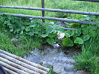
The village lies at an altitude of 881 metres and covers an area of 55.974 km². It has population of about 1,531 people. The Hron river rises in the cadastral area of the village, under the Kráľova hoľa mountain.

| Municipalities of Brezno District | ||
|---|---|---|
This Banská Bystrica Region geography article is a stub. You can help Misplaced Pages by expanding it. |