| Revision as of 15:26, 19 November 2015 edit194.96.237.224 (talk)No edit summary← Previous edit | Revision as of 16:24, 19 November 2015 edit undoMai-Sachme (talk | contribs)Extended confirmed users7,496 edits Undid revision 691395701 by 194.96.237.224 (talk)Next edit → | ||
| Line 1: | Line 1: | ||
| {{for|the French ''commune''|Laives, Saône-et-Loire}} | {{for|the French ''commune''|Laives, Saône-et-Loire}} | ||
| {{Infobox Italian comune | {{Infobox Italian comune | ||
| | name = |
| name = Laives | ||
| | official_name = Gemeinde Leifers | | official_name = Comune di Laives<br>Gemeinde Leifers | ||
| | native_name = | | native_name = | ||
| | image_skyline =Leifers, |
| image_skyline =Leifers,_Bolzano,_Italy.png | ||
| | imagesize = | | imagesize = | ||
| | image_alt = | | image_alt = | ||
Revision as of 16:24, 19 November 2015
For the French commune, see Laives, Saône-et-Loire. Comune in Trentino-Alto Adige/Südtirol, Italy| Laives | |
|---|---|
| Comune | |
| Comune di Laives Gemeinde Leifers | |
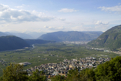
 Panorama of Laives. Panorama of Laives. | |
| Location of Laives | |
| Country | Italy |
| Region | Trentino-Alto Adige/Südtirol |
| Province | South Tyrol (BZ) |
| Frazioni | Pineta (Steinmannwald), La Costa (Seit), San Giacomo (St. Jakob) |
| Government | |
| • Mayor | Christian Bianchi |
| Area | |
| • Total | 24.3 km (9.4 sq mi) |
| Elevation | 258 m (846 ft) |
| Population | |
| • Total | 17,168 |
| • Density | 710/km (1,800/sq mi) |
| Demonym(s) | Italian: Laivesotti German: Leiferer |
| Time zone | UTC+1 (CET) |
| • Summer (DST) | UTC+2 (CEST) |
| Postal code | 39055 |
| Dialing code | 0471 |
| Website | Official website |
Laives (Template:Lang-de) is a town and a comune (municipality) in South Tyrol in northern Italy, located about 8 kilometres (5 mi) south of the city of Bolzano. It is one of only five mainly Italian speaking municipalities in South Tyrol, and the fourth largest municipality in the province.
Geography
As of November 30, 2010, it had a population of 17,168 and an area of 24.3 square kilometres (9.4 sq mi).
Frazioni
The municipality contains the frazioni (subdivisions) Pineta (Steinmannwald), La Costa (Seit) and San Giacomo (St. Jakob)
History
Coat-of-arms
The emblem consists of an argent pile, with concave sides on azure and a chapel on a mountain of gules. The sign, similar to that of the Counts of Lichtenstein who lived in the castle on Mount Köfele, represents the church of Peterköfele. The emblem was adopted in 1970.
Society
Linguistic distribution
According to the 2011 census, 71.50% of the population speak Italian, 27.99% German and 0.51% Ladin as first language.
| Language | 2001 | 2011 |
|---|---|---|
| German | 29.07% | 27.99% |
| Italian | 70.42% | 71.50% |
| Ladin | 0.51% | 0.51% |
References
- "Superficie di Comuni Province e Regioni italiane al 9 ottobre 2011". Italian National Institute of Statistics. Retrieved 16 March 2019.
- ^ All demographics and other statistics: Italian statistical institute Istat.
- Heraldry of the World: Laives
- ^ "Volkszählung 2011/Censimento della popolazione 2011". astat info (38). Provincial Statistics Institute of the Autonomous Province of South Tyrol: 6–7. June 2012. Retrieved 2012-06-14.
- Oscar Benvenuto (ed.): "South Tyrol in Figures 2008", Provincial Statistics Institute of the Autonomous Province of South Tyrol, Bozen/Bolzano 2007, p. 17, table 10
External links
![]() Media related to Laives at Wikimedia Commons
Media related to Laives at Wikimedia Commons
This Trentino-Alto Adige/Südtirol location article is a stub. You can help Misplaced Pages by expanding it. |
