| Revision as of 00:55, 20 December 2014 editAbstrakt (talk | contribs)Extended confirmed users, Pending changes reviewers7,287 editsNo edit summary← Previous edit | Revision as of 23:15, 1 December 2015 edit undoASDFGH (talk | contribs)Autopatrolled, Extended confirmed users, Pending changes reviewers77,166 editsNo edit summaryNext edit → | ||
| Line 1: | Line 1: | ||
| {{Infobox settlement | {{Infobox settlement | ||
| |name = Jimsar County | |name = Jimsar County | ||
| |native_name = {{lower|0.1em|{{nobold|{{lang|zh-hans|吉木萨尔县}} • {{lang|zh|کِمُوسَاعَر ﺷِﯿًﺎ}} • {{lang|ug|جىمىسار ناھىيىسى}}<br>{{small|(]) • (]) • (])}}}}}} | |||
| |native_name = جىمىسار ناھىيىسى<br>吉木萨尔县 | |||
| |pushpin_label_position = right | |pushpin_label_position = right | ||
| |pushpin_map_caption = Location within China | |pushpin_map_caption = Location within China | ||
Revision as of 23:15, 1 December 2015
County in Xinjiang, China| Jimsar County
吉木萨尔县 • کِمُوسَاعَر ﺷِﯿًﺎ • جىمىسار ناھىيىسى (Chinese) • (Uyghur) • (Xiao'erjing) | |
|---|---|
| County | |
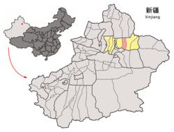
 Location of Jimsar County (pink) in Changji Prefecture (yellow) and Xinjiang (grey) Location of Jimsar County (pink) in Changji Prefecture (yellow) and Xinjiang (grey) | |
| Country | China |
| Province | Xinjiang |
| Prefecture-level divisions | Changji Hui Autonomous Prefecture |
| Township-level divisions | 4 towns 4 townships |
| County seat | Jimsar Town (吉木萨尔镇) |
| Time zone | UTC+8 (China Standard) |
Jimsar County (Chinese: 吉木萨尔县; pinyin: Jímùsà'ěr Xiàn; Xiao'erjing: کِمُوسَاعَر ﺷِﯿًﺎ; Template:Ug) is a county in Changji Hui Autonomous Prefecture, Xinjiang, China. It contains an area of 8,149 km. According to the 2002 census, it has a population of 130,000.
History
The name Beshbalik first appears in history in the description of the events of 713 in the Turkic Kul Tegin inscription. It was one of the largest of 5 towns in the Uyghur Khaganate in Mongolia. The Tibetans briefly held the city in 790. Established in 1902 as a county, it was known as Fuyuan (孚远) until 1952, when its name was changed to Jimsar.
The modern city Jimsar is located at 43°59'N, 89°4'East; it is a location of the Uyghur ancient southern capital Beshbalik or Beshbalyk (Turkic Head (or Main) Area (or Space, Section, Location), although in modern Turkish "Beşbalık (or "Beshbalyk") literally means "Five Fish", the closest approximation of "Beshbalyk" would be "Baş (Main, Top, Central, Head, etc.) Boluk (Area, Location) or Başboluk). It became the Uyghur main capital after a disastrous results of the Yenisei Kirghiz attack on the Uyghur northern capital Karabalgasun (Khanbalyk).
After the attack, a significant part of the Uyghur Khaganate population fled to the area of the present Jimsar County and Tarim Basin in general in 840, where they founded the Kingdom of Qocho. The Uyghurs submitted to Genghis Khan in 1207. Beshbalik consisted of five parts: an outer town, the northern gate of the outer town, the extended town of the west, the inner town and a small settlement within the inner town. At first, the city was the political center of the Uyghur Idiquit (monarch) and his Mongol queen, Altalun, daughter of Genghis Khan under the Mongol Empire in the first half of the 13th century. Due to military struggles between the Chagatai Khanate and the Yuan Dynasty during the reign of Kublai Khan, the city was abandoned and lost its prosperity in the late 13th century.
Jimsar city was established in the south of the ruins of Beshbalik.
Notes
- Bosworth, M.S.Asimov-History of Civilizations of Central Asia, Volume 4, Part 2, p.578
- C. E. Bosworth, M.S.Asimov, History of Civilizations of Central Asia, Volume 4, Part 2, p.578, line-23
- Denis Sinor-The Cambridge history of early Inner Asia, Volume 1, p.319
- C. Beckwith, Empires of the Silk Road: A History of Central Eurasia from the Bronze Age to the Present, Princeton University Press, 2009, pp. 148, 159
- Jack Weatherford, The Secret History of the Mongol Queens
- Paul Allan Mirecki, Jason BeDuhn, Emerging from Darkness: Studies in the Recovery of Manichaean Sources, p. 106
References
- Beckwith, Christopher I. (2009). Empires of the Silk Road: A History of Central Eurasia from the Bronze Age to the Present. Princeton University Press. ISBN 978-0-691-13589-2.
- Area map http://www.maplandia.com/china/xinjiang-uygur/jimsar/jimsar/
| County-level divisions of Xinjiang Uyghur Autonomous Region | |||||||||
|---|---|---|---|---|---|---|---|---|---|
| Ürümqi (capital) | |||||||||
| Prefecture-level cities |
| ||||||||
| Sub-provincial autonomous prefecture |
| ||||||||
| Prefectures |
| ||||||||
| Autonomous prefectures |
| ||||||||
| XPCC administered |
| ||||||||
| |||||||||
43°59′N 89°04′E / 43.983°N 89.067°E / 43.983; 89.067
This Xinjiang location article is a stub. You can help Misplaced Pages by expanding it. |