| Revision as of 04:28, 19 January 2017 editJJMC89 bot (talk | contribs)Bots1,161,037 edits Migrate {{Infobox German location}} coordinates parameters to {{Coord}}, see Misplaced Pages:Coordinates in infoboxes← Previous edit | Revision as of 19:25, 9 February 2017 edit undoVivo (talk | contribs)421 edits Removed "See also" – Only humorous aspects, not geographicalNext edit → | ||
| Line 26: | Line 26: | ||
| The first mention of the municipality was in 1048 with the name ''Pettinga''; however, it is possible that the settlement already existed at the time of the ]. In 1180 it came into the ownership of the monastery St. Zeno. | The first mention of the municipality was in 1048 with the name ''Pettinga''; however, it is possible that the settlement already existed at the time of the ]. In 1180 it came into the ownership of the monastery St. Zeno. | ||
| ==See also== | |||
| *] | |||
| *] | |||
| *] | |||
| *] | |||
| *] | |||
| *] | |||
| *] | |||
| ==References== | ==References== | ||
| Line 46: | Line 37: | ||
| {{Authority control}} | {{Authority control}} | ||
| ] | ] | ||
| {{Traunsteindistrict-geo-stub}} | {{Traunsteindistrict-geo-stub}} | ||
Revision as of 19:25, 9 February 2017
Municipality in Bavaria, Germany| Petting | |
|---|---|
| Municipality | |
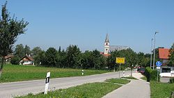
 Petting as viewed from South Petting as viewed from South | |
 Coat of arms Coat of arms | |
Location of Petting within Traunstein district
 | |
  | |
| Coordinates: 47°55′N 12°49′E / 47.917°N 12.817°E / 47.917; 12.817 | |
| Country | Germany |
| State | Bavaria |
| Admin. region | Oberbayern |
| District | Traunstein |
| Subdivisions | Hauptorte: Petting, Ringham, Schönram, Kühnhausen |
| Government | |
| • Mayor | Karl Lanzinger |
| Area | |
| • Total | 29.93 km (11.56 sq mi) |
| Elevation | 451 m (1,480 ft) |
| Population | |
| • Total | 2,396 |
| • Density | 80/km (210/sq mi) |
| Time zone | UTC+01:00 (CET) |
| • Summer (DST) | UTC+02:00 (CEST) |
| Postal codes | 83367, 83419 |
| Dialling codes | 08686 |
| Vehicle registration | TS |
| Website | www.gemeinde-petting.de |
Petting is a municipality in the district Traunstein, Bavaria, Germany. It is located on the shore of the Waginger See, a diluvial lake.
The first mention of the municipality was in 1048 with the name Pettinga; however, it is possible that the settlement already existed at the time of the Roman Empire. In 1180 it came into the ownership of the monastery St. Zeno.
References
- Genesis Online-Datenbank des Bayerischen Landesamtes für Statistik Tabelle 12411-003r Fortschreibung des Bevölkerungsstandes: Gemeinden, Stichtag (Einwohnerzahlen auf Grundlage des Zensus 2011).
External links
- Official website of the municipality (German)
This Traunstein district location article is a stub. You can help Misplaced Pages by expanding it. |