| Revision as of 15:53, 12 May 2017 editBermicourt (talk | contribs)Autopatrolled, Extended confirmed users, New page reviewers, Pending changes reviewers, Rollbackers152,142 edits added Category:Three-thousanders using HotCat← Previous edit | Revision as of 22:40, 2 June 2017 edit undoRye-96 (talk | contribs)Extended confirmed users2,673 edits Fixed the infobox and modified the lede.Next edit → | ||
| Line 2: | Line 2: | ||
| | name = Tochal | | name = Tochal | ||
| | photo = Tochal-Tehran.jpg | | photo = Tochal-Tehran.jpg | ||
| | photo_caption = Mount Tochal |
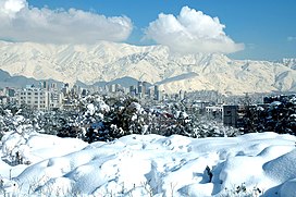
| photo_caption = Mount Tochal, located to the north of ]. | ||
| | elevation_m = 3,933 | | elevation_m = 3,933 | ||
| | elevation_ref = | | elevation_ref = | ||
| Line 8: | Line 8: | ||
| | location = ], ] | | location = ], ] | ||
| | range = ] | | range = ] | ||
| | map = Iran | |
| map = Iran |map_relief=1 | ||
| | coordinates = ≈{{coord|35|53|04|N|51|25|09|E|type:mountain}} | | coordinates = ≈{{coord|35|53|04|N|51|25|09|E|type:mountain}} | ||
| | type = | | type = | ||
| Line 17: | Line 17: | ||
| }} | }} | ||
| ''' |
'''Tochal''' ({{lang-fa|توچال}} {{transl|fa|''Točāl''}}) is a mountain and ski resort located on the ] mountain range, adjacent to the metropolitan area of ] in northern ]. It includes a 12-kilometer-long ridge. Its highest peak, also called ''Tochal'', is at an elevation of 3,933 meters (13,005 feet). | ||
| Tochal is a popular recreational region for Tehran's residents. | |||
| A ] |
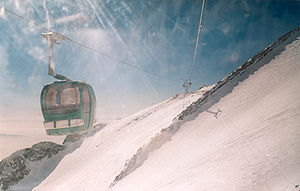
A ] runs from Tehran to the Tochal ski resort and hotel, all as a part of ]. | ||
| ==Peaks== | ==Peaks== | ||
Revision as of 22:40, 2 June 2017
| Tochal | |
|---|---|
 Mount Tochal, located to the north of Tehran. Mount Tochal, located to the north of Tehran. | |
| Highest point | |
| Elevation | 3,933 m (12,904 ft) |
| Coordinates | ≈35°53′04″N 51°25′09″E / 35.88444°N 51.41917°E / 35.88444; 51.41917 |
| Geography | |
 | |
| Parent range | Alborz |
Tochal (Template:Lang-fa Točāl) is a mountain and ski resort located on the Alborz mountain range, adjacent to the metropolitan area of Tehran in northern Iran. It includes a 12-kilometer-long ridge. Its highest peak, also called Tochal, is at an elevation of 3,933 meters (13,005 feet).
A gondola lift runs from Tehran to the Tochal ski resort and hotel, all as a part of Tochal Complex.
Peaks
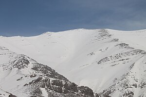
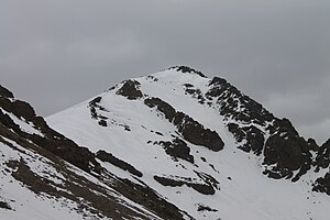
A number of peaks are accessible from the Tochal main ridge or by their own climbing paths. Peaks (from west to east) include:
- Lavarak (3560m): accessible by main Tochal ridge or Imamzade Davood climbing path.
- Bazarak (3753m): accessible by main Tochal ridge or Imamzade Davood climbing path.
- Palang-chal (3520m): accessible from Darakeh valley and Palangchal Shelter.
- Sar-Bazarak (3640m): accessible from Palangchal peak and main Tochal ridge.
- Shah-Neshin (3875m): accessible from Tochal main ridge, Hezarcham path and south (Abshar-Dogholoo) ridge.
- Tochal (3933m): The highest peak of the range, accessible by any climbing path that ends on the Tochal main ridge. The usual path from Tehran is by the south ridge (normally from Shirpala shelter and Siahsang hut).
- Spilit (3120m): through Band-yakh-chal and Shervin hut by rock climbing or Klakchal ridge.
- West Lezon (3585m): accessible from Tochal main ridge, Kolakchal shelter or Shirpala shelter.
- East Lezon or Piaz-chal (3540m): accessible from Tochal main ridge, Kolakchal shelter or Shirpala shelter.
- Kolak-chal (3350m): from Kolakchal shelter (through Golab-dareh valley, Vezbad valley or Jamshidieh park)
- Siah-band (3320m): from Dar-abad valley and Dar-abad hut.
Gondola lift


Tochal has a long gondola lift which begins from Velenjak valley at 1900m and ends in the last station at 3740m near the main ridge of Tochal. This gondola lift is used for accessing ski resorts and other recreational centers on the mountain. The gondola lift has four stations:
- Station 1 is at an elevation of 1900m and located at the beginning of Velenjak valley (end of Velenjak Street). Parking, inns and some other facilities are available.
- Station 2 is at 2400m and has very limited facilities.
- Station 5 is at 2935m. There is a restaurant and a rescue center. This station is in the middle of one of the ski slopes which is open only in mid winter. This station is also accessible through several climbing paths like Shirpala shelter, Osoon valley and Palang-chal shelter.
- Station 7 is at 3740m and very close to the Tochal main ridge. It is the last station of the gondola lift. This station is in the middle of the Tochal ski slope. The Tochal main peak is 30 minutes walk from this point. This station is also reachable from Hezar-cham climbing path from Station 5.
Location in central Alborz
| Map of central Alborz | Peaks: | 1 Alam-Kuh |
|---|---|---|
 |
2 Azad Kuh | 3 Damavand |
| 4 Do Berar | 5 Do Khaharan | |
| 6 Ghal'eh Gardan | 7 Gorg | |
| 8 Kholeno | 9 Mehr Chal | |
| 10 Mishineh Marg | 11 Naz | |
| 12 Shah Alborz | 13 Sialan | |
| 14 Tochal | 15 Varavašt | |
| Rivers: | 0 | |
| 1 Alamut | 2 Chalus | |
| 3 Do Hezar | 4 Haraz | |
| 5 Jajrood | 6 Karaj | |
| 7 Kojoor | 8 Lar | |
| 9 Noor | 10 Sardab | |
| 11 Seh Hazar | 12 Shahrood | |
| Cities: | 1 Amol | |
| 2 Chalus | 3 Karaj | |
| Other: | D Dizin | |
| E Emamzadeh Hashem | K Kandovan Tunnel | |
| * Latyan Dam | ** Lar Dam |


