| Revision as of 15:27, 22 September 2006 editMahak library (talk | contribs)136 editsm forgot to remove a couple of sentences. spell "upto" --> "up to"← Previous edit | Revision as of 18:57, 3 October 2006 edit undoBobblewik (talk | contribs)66,026 editsm units | units &/or linksNext edit → | ||
| Line 18: | Line 18: | ||
| ==Climate and soil== | ==Climate and soil== | ||
| The district Layyah has an extremely hot climate. Maximum temperature in the summer goes up to 45 degree |
The district Layyah has an extremely hot climate. Maximum temperature in the summer goes up to 45 degree Celsius. The temperature in winter is low due to nearness to Koh-Suleman range of mountains. The tehsil Chaubara is almost barren and consists of forest and sand dunes. It is actually a ‘Rakh’ under the control of Forest Department. The thesil of Layyah and Karor Lal Esan are comparatively better developed agriculturally but they have also large tracks of sand dunes and uncultivated land. The river Indus passes from North to South on Western side of the district and touches D.G.Khan. | ||
| ==Distract at a glance== | ==Distract at a glance== | ||
| 1. Population: 1,121000 | 1. Population: 1,121000 | ||
| 2. Area: 6,291 |
2. Area: 6,291 km² | ||
| 3. Population |
3. Population density: 178 per km². | ||
| 4. Tehsils: Layyah, Chaubara and Karor Lal Esan. | 4. Tehsils: Layyah, Chaubara and Karor Lal Esan. | ||
| Line 37: | Line 37: | ||
| 8. Main Vegetables: Onion and Potatoes. | 8. Main Vegetables: Onion and Potatoes. | ||
| 9. Forest: 34,338 acres | 9. Forest: 34,338 acres (139 km²) | ||
| 10. Total Metalled Roads: 869 |
10. Total Metalled Roads: 869 km | ||
| 11. No. of Grid Stations: 7 | 11. No. of Grid Stations: 7 | ||
Revision as of 18:57, 3 October 2006


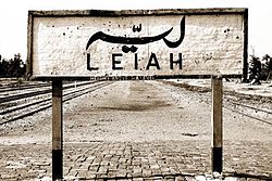
Layyah District (Urdu: لیہ ) is a district in the Punjab, Pakistan. It is located in the southern part of the province. The capital is Layyah. It is a very historical city.
Description
District Layyah (formerly spelled as Leiah) is bounded to the North by Bhakkar District, to East by Jhang District. River Indus flows to its Western side across which lies district D.G.Khan and to the South district Muzaffargarh. District Layyah has an area of 6291 square kilometres and comprises the three tehsils of:
- Layyah
- Chaubara
- Karor Lal Esan
The word 'Leiah' itself is believed to be derived from 'Leian' in Saraiki language, a plural form of 'Lai' which is a name of bush. In former times, the land in Layyah (Leiah) was mostly covered by sand dunes with bushes (Leian). Therefore this place was known as 'Leian' which became 'Leiah' afterwards.
Majority of people in Layyah are native speakers of Saraiki or Punjabi language, although Urdu is widely understood and spoken. The medium of education is Urdu and English.
Climate and soil
The district Layyah has an extremely hot climate. Maximum temperature in the summer goes up to 45 degree Celsius. The temperature in winter is low due to nearness to Koh-Suleman range of mountains. The tehsil Chaubara is almost barren and consists of forest and sand dunes. It is actually a ‘Rakh’ under the control of Forest Department. The thesil of Layyah and Karor Lal Esan are comparatively better developed agriculturally but they have also large tracks of sand dunes and uncultivated land. The river Indus passes from North to South on Western side of the district and touches D.G.Khan.
Distract at a glance
1. Population: 1,121000
2. Area: 6,291 km²
3. Population density: 178 per km².
4. Tehsils: Layyah, Chaubara and Karor Lal Esan.
5. Main Towns: Chowk Azam, Chowk Fatehpur and Kot Sultan
6. Main Crops: Sugarcane, Wheat, Cotton, Gram and Guar seed.
7. Main Fruits: Citrus and Dates.
8. Main Vegetables: Onion and Potatoes.
9. Forest: 34,338 acres (139 km²)
10. Total Metalled Roads: 869 km
11. No. of Grid Stations: 7
12. No. of Telephone Exchanges: 18
13. Number of Industrial Units: 365
14. Major Industries: Cotton Ginning & Pressing, Flour Mills, Oil Mills and Sugar.