| Revision as of 11:29, 17 October 2017 edit46.12.219.213 (talk)No edit summary← Previous edit | Revision as of 11:33, 17 October 2017 edit undo46.12.219.213 (talk)No edit summaryNext edit → | ||
| Line 20: | Line 20: | ||
| '''Lefkonas''' ({{lang-el|Λευκώνας}}) is a village and a former municipality in the ], ]. Since the 2011 local government reform it is part of the municipality ], of which it is a municipal unit.<ref name=Kallikratis> Greece Ministry of Interior {{el icon}}</ref> The municipal unit has an area of 68.247 km<sup>2</sup>.<ref name=stat01>{{cite web|url=http://dlib.statistics.gr/Book/GRESYE_02_0101_00098%20.pdf |publisher=National Statistical Service of Greece |title=Population & housing census 2001 (incl. area and average elevation) |language=el |deadurl=yes |archiveurl=https://web.archive.org/web/20150921212047/http://dlib.statistics.gr/Book/GRESYE_02_0101_00098%20.pdf |archivedate=2015-09-21 |df= }}</ref> Population 3,905 (2011). | '''Lefkonas''' ({{lang-el|Λευκώνας}}) is a village and a former municipality in the ], ]. Since the 2011 local government reform it is part of the municipality ], of which it is a municipal unit.<ref name=Kallikratis> Greece Ministry of Interior {{el icon}}</ref> The municipal unit has an area of 68.247 km<sup>2</sup>.<ref name=stat01>{{cite web|url=http://dlib.statistics.gr/Book/GRESYE_02_0101_00098%20.pdf |publisher=National Statistical Service of Greece |title=Population & housing census 2001 (incl. area and average elevation) |language=el |deadurl=yes |archiveurl=https://web.archive.org/web/20150921212047/http://dlib.statistics.gr/Book/GRESYE_02_0101_00098%20.pdf |archivedate=2015-09-21 |df= }}</ref> Population 3,905 (2011). | ||
| Near the village the location of an ancient settlement has been found.<ref> |
Near the village - on the hill of "Simitzi-bair" - the location of an ancient settlement has been found.<ref> Dimitrios C. Samsaris, A History of Serres (in the Ancient and Roman Times) (in Greek), Thessaloniki 1999, p. 164 (Website of Municipality of Serres)</ref> | ||
| == External links == | == External links == | ||
Revision as of 11:33, 17 October 2017
Settlement in Greece| Lefkonas Λευκώνας | |
|---|---|
| Settlement | |
  | |
| Coordinates: 41°06′N 23°29′E / 41.100°N 23.483°E / 41.100; 23.483 | |
| Country | Greece |
| Administrative region | Central Macedonia |
| Regional unit | Serres |
| Municipality | Serres |
| Area | |
| • Municipal unit | 68.2 km (26.3 sq mi) |
| Population | |
| • Municipal unit | 3,905 |
| • Municipal unit density | 57/km (150/sq mi) |
| • Community | 2,388 |
| Time zone | UTC+2 (EET) |
| • Summer (DST) | UTC+3 (EEST) |
| Vehicle registration | ΕΡ |
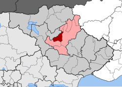
Lefkonas (Template:Lang-el) is a village and a former municipality in the Serres regional unit, Greece. Since the 2011 local government reform it is part of the municipality Serres, of which it is a municipal unit. The municipal unit has an area of 68.247 km. Population 3,905 (2011).
Near the village - on the hill of "Simitzi-bair" - the location of an ancient settlement has been found.
External links
See also
List of settlements in the Serres regional unit
References
- "Απογραφή Πληθυσμού - Κατοικιών 2011. ΜΟΝΙΜΟΣ Πληθυσμός" (in Greek). Hellenic Statistical Authority.
- Kallikratis law Greece Ministry of Interior Template:El icon
- "Population & housing census 2001 (incl. area and average elevation)" (PDF) (in Greek). National Statistical Service of Greece. Archived from the original (PDF) on 2015-09-21.
{{cite web}}: Unknown parameter|deadurl=ignored (|url-status=suggested) (help) - Dimitrios C. Samsaris, A History of Serres (in the Ancient and Roman Times) (in Greek), Thessaloniki 1999, p. 164 (Website of Municipality of Serres)
| Subdivisions of the municipality of Serres | |
|---|---|
| Municipal unit of Ano Vrontou | |
| Municipal unit of Kapetan Mitrousi |
|
| Municipal unit of Lefkonas |
|
| Municipal unit of Oreini | |
| Municipal unit of Serres |
|
| Municipal unit of Skoutari |
|
This Central Macedonia location article is a stub. You can help Misplaced Pages by expanding it. |