| Revision as of 18:16, 29 May 2020 editChongkian (talk | contribs)Autopatrolled, Event coordinators, Extended confirmed users373,483 edits remove self-redirect link← Previous edit | Revision as of 02:54, 26 June 2020 edit undoInternetArchiveBot (talk | contribs)Bots, Pending changes reviewers5,381,602 edits Rescuing 1 sources and tagging 1 as dead.) #IABot (v2.0.1Next edit → | ||
| Line 94: | Line 94: | ||
| ==Administrative divisions== | ==Administrative divisions== | ||
| Bali District administers ten ]:<ref>{{citeweb|url=https://www.bali.ntpc.gov.tw/content/?parent_id=10043|script-title=zh:行政區域|date=24 June 2017|accessdate=30 June 2019|quote=八里區的行政區隸屬於新北市,為新北市廿九個區之一,全區又可分為十個里,分別為埤頭、頂罟、舊城、訊塘、荖阡、下罟、長坑、龍源、米倉及大崁,|language=zh-tw|website=Bali District Office New Taipei City}}</ref><ref>{{citeweb|url=http://vote2018.cec.gov.tw/pc/en/CV/m65000002300010000.html|title=2018 Local Elections|quote=Longyuan Vil. Micang Vil. Dakan Vil. Beitou Vil. Dinggu Vil. Jiucheng Vil. Xuntang Vil. Peiqian Vil. Zhangkeng Vil. Xiagu Vil.|accessdate=30 June 2019|website=]}}, Chinese version: </ref> | Bali District administers ten ]:<ref>{{citeweb|url=https://www.bali.ntpc.gov.tw/content/?parent_id=10043|script-title=zh:行政區域|date=24 June 2017|accessdate=30 June 2019|quote=八里區的行政區隸屬於新北市,為新北市廿九個區之一,全區又可分為十個里,分別為埤頭、頂罟、舊城、訊塘、荖阡、下罟、長坑、龍源、米倉及大崁,|language=zh-tw|website=Bali District Office New Taipei City}}</ref><ref>{{citeweb|url=http://vote2018.cec.gov.tw/pc/en/CV/m65000002300010000.html|title=2018 Local Elections|quote=Longyuan Vil. Micang Vil. Dakan Vil. Beitou Vil. Dinggu Vil. Jiucheng Vil. Xuntang Vil. Peiqian Vil. Zhangkeng Vil. Xiagu Vil.|accessdate=30 June 2019|website=]|archive-url=https://web.archive.org/web/20190630065640/http://vote2018.cec.gov.tw/pc/en/CV/m65000002300010000.html|archive-date=30 June 2019|url-status=dead}}, Chinese version: {{Dead link|date=June 2020 |bot=InternetArchiveBot |fix-attempted=yes }}</ref> | ||
| * Longyuan ({{linktext|lang=zh-tw|龍源|里}}), Micang ({{linktext|lang=zh-tw|米倉|里}}), Dakan ({{linktext|lang=zh-tw|大崁|里}}), {{citation needed span|Pitou/Beitou|date=June 2019|reason=Google Maps has a "Pitou 1st Street" in the area. If 'Beitou' is invalid, this would seem to cast doubt on the authoritativeness of the other transliterations provided by the '2018 Local Elections' source.}} ({{linktext|lang=zh-tw|埤頭|里}}), Dinggu ({{linktext|lang=zh-tw|頂罟|里}}), Jiucheng ({{linktext|lang=zh-tw|舊城|里}}), Xuntang ({{linktext|lang=zh-tw|訊塘|里}}), {{citation needed span|Laoqian/Peiqian|date=June 2019|reason=A sign in the northern part of 荖阡里 reads "荖阡坑路 Lao- qian keng Rd." in Google Street View. https://www.google.com/maps/@25.14446,121.3982857,3a,15y,114.97h,95.14t/data=!3m6!1e1!3m4!1sGN7WalNl1ZuoC427VUKTHQ!2e0!7i13312!8i6656}} ({{linktext|lang=zh-tw|荖阡|里}}), {{citation needed span|Changkeng/Zhangkeng|date=June 2019|reason=A local school is called "長坑國民小學 Changkeng Elementary School" which conflicts with the Google Maps name "Zhangkeng Elementary School 新北市八里區長坑國民小學". https://www.google.com/maps/@25.125528,121.3902552,3a,15y,104.65h,103.81t/data=!3m8!1e1!3m6!1sAF1QipO9SU1HEjVM-5kUpL9UWAEtVV52DkQoRo3TYUnF!2e10!3e11!6shttps:%2F%2Flh5.googleusercontent.com%2Fp%2FAF1QipO9SU1HEjVM-5kUpL9UWAEtVV52DkQoRo3TYUnF%3Dw203-h100-k-no-pi-0-ya92.03073-ro-0-fo100!7i8704!8i4352}} ({{linktext|lang=zh-tw|長坑|里}}) and Xiagu ({{linktext|lang=zh-tw|下罟|里}}) Village. | * Longyuan ({{linktext|lang=zh-tw|龍源|里}}), Micang ({{linktext|lang=zh-tw|米倉|里}}), Dakan ({{linktext|lang=zh-tw|大崁|里}}), {{citation needed span|Pitou/Beitou|date=June 2019|reason=Google Maps has a "Pitou 1st Street" in the area. If 'Beitou' is invalid, this would seem to cast doubt on the authoritativeness of the other transliterations provided by the '2018 Local Elections' source.}} ({{linktext|lang=zh-tw|埤頭|里}}), Dinggu ({{linktext|lang=zh-tw|頂罟|里}}), Jiucheng ({{linktext|lang=zh-tw|舊城|里}}), Xuntang ({{linktext|lang=zh-tw|訊塘|里}}), {{citation needed span|Laoqian/Peiqian|date=June 2019|reason=A sign in the northern part of 荖阡里 reads "荖阡坑路 Lao- qian keng Rd." in Google Street View. https://www.google.com/maps/@25.14446,121.3982857,3a,15y,114.97h,95.14t/data=!3m6!1e1!3m4!1sGN7WalNl1ZuoC427VUKTHQ!2e0!7i13312!8i6656}} ({{linktext|lang=zh-tw|荖阡|里}}), {{citation needed span|Changkeng/Zhangkeng|date=June 2019|reason=A local school is called "長坑國民小學 Changkeng Elementary School" which conflicts with the Google Maps name "Zhangkeng Elementary School 新北市八里區長坑國民小學". https://www.google.com/maps/@25.125528,121.3902552,3a,15y,104.65h,103.81t/data=!3m8!1e1!3m6!1sAF1QipO9SU1HEjVM-5kUpL9UWAEtVV52DkQoRo3TYUnF!2e10!3e11!6shttps:%2F%2Flh5.googleusercontent.com%2Fp%2FAF1QipO9SU1HEjVM-5kUpL9UWAEtVV52DkQoRo3TYUnF%3Dw203-h100-k-no-pi-0-ya92.03073-ro-0-fo100!7i8704!8i4352}} ({{linktext|lang=zh-tw|長坑|里}}) and Xiagu ({{linktext|lang=zh-tw|下罟|里}}) Village. | ||
Revision as of 02:54, 26 June 2020
Not to be confused with Bali, Indonesia. District in New Taipei City, Republic of China| Bali 八里區 | |
|---|---|
| District | |
| Bali District | |
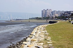
 Shoreside in Bali District Shoreside in Bali District | |
 Bali District in New Taipei City Bali District in New Taipei City | |
| Coordinates: 25°9′N 121°24′E / 25.150°N 121.400°E / 25.150; 121.400 | |
| Country | Republic of China (Taiwan) |
| City | New Taipei City |
| Area | |
| • Total | 15.25 sq mi (39.49 km) |
| Population | |
| • Total | 37,711 |
| Time zone | +8 |
| Website | www.bali.ntpc.gov.tw (in Chinese) |
Bali District (Chinese: 八里區; pinyin: Bālǐ Qū; Pe̍h-ōe-jī: Pat-lí-khu) is a rural district in the northwestern part of New Taipei, Taiwan. In Taiwanese Hokkien, it was known as Pat-lí-hun (八里坌) during the rule of the Qing Dynasty.
History


During the period of Japanese rule, Bali was called Hachiri village (八里庄), and was governed under Tamsui District of Taihoku Prefecture. After the handover of Taiwan from Japan to the Republic of China in 1945, Bali became a rural township of Taipei County. On 25 December 2010, it became a district of New Taipei City.
Administrative divisions
Bali District administers ten urban villages:
- Longyuan (龍源里), Micang (米倉里), Dakan (大崁里), Pitou/Beitou (埤頭里), Dinggu (頂罟里), Jiucheng (舊城里), Xuntang (訊塘里), Laoqian/Peiqian (荖阡里), Changkeng/Zhangkeng (長坑里) and Xiagu (下罟里) Village.
Education
Bali district has one high school, one municipal middle school, and five elementary schools, including the New Taipei Municipal DaKan Elementary School.

Tourist attractions
Transportation
References
- "Bali travel guide of hot destinations(旅遊王TravelKing)–Taiwan travel hotels,New Taipei City tourism,Bali". Travelking.com.tw. Retrieved 2014-05-25.
- 臺灣歷史地圖 增訂版 [Taiwan Historical Maps, Expanded and Revised Edition] (in Chinese (Taiwan)). Taipei: National Museum of Taiwan History. February 2018. p. 120. ISBN 978-986-05-5274-4.
臺北廳行政區域圖 1909年{...}滬尾支廳 小八里坌區
- 行政區域. Bali District Office New Taipei City (in Chinese (Taiwan)). 24 June 2017. Retrieved 30 June 2019.
八里區的行政區隸屬於新北市,為新北市廿九個區之一,全區又可分為十個里,分別為埤頭、頂罟、舊城、訊塘、荖阡、下罟、長坑、龍源、米倉及大崁,
- "2018 Local Elections". Central Election Commission. Archived from the original on 30 June 2019. Retrieved 30 June 2019.
Longyuan Vil. Micang Vil. Dakan Vil. Beitou Vil. Dinggu Vil. Jiucheng Vil. Xuntang Vil. Peiqian Vil. Zhangkeng Vil. Xiagu Vil.
, Chinese version:
External links
 Bali District travel guide from Wikivoyage
| Districts in Taiwan | |||||||||||||
|---|---|---|---|---|---|---|---|---|---|---|---|---|---|
| List of townships/cities and districts in Taiwan | |||||||||||||
| Special municipalities |
| ||||||||||||
| Cities |
| ||||||||||||
| ¹ — Mountain indigenous district | |||||||||||||
25°09′N 121°24′E / 25.150°N 121.400°E / 25.150; 121.400
This article about a location in Taiwan is a stub. You can help Misplaced Pages by expanding it. |