| Revision as of 10:27, 28 June 2020 editBHGbot (talk | contribs)132,943 editsm WP:BHGbot 6 (List 5): eponymous category first, per MOS:CATORDER; WP:GENFIXESTag: AWB← Previous edit | Revision as of 00:02, 7 October 2020 edit undoHüseyn Musayev (talk | contribs)1 editNo edit summaryTags: Reverted Mobile edit Mobile web editNext edit → | ||
| Line 9: | Line 9: | ||
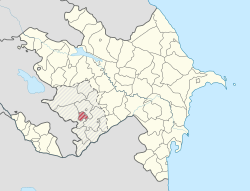
| | map_caption = Map of Azerbaijan showing Shusha District | | map_caption = Map of Azerbaijan showing Shusha District | ||
| | subdivision_type = Country | | subdivision_type = Country | ||
| | subdivision_name = ] - ] | | subdivision_name = ] | ||
| | population_as_of = 2009 | | population_as_of = 2009 | ||
| | population_footnotes =<ref name="azerbaijanis">{{Cite news | | population_footnotes =<ref name="azerbaijanis">{{Cite news | ||
Revision as of 00:02, 7 October 2020
- For the administrative province at the south-eastern part of the unrecognized Nagorno-Karabakh Republic, see Shushi Region
| Shusha | |
|---|---|
| District | |
 Map of Azerbaijan showing Shusha District Map of Azerbaijan showing Shusha District | |
| Country | Azerbaijan Republic |
| Capital | Shusha |
| Area | |
| • Total | 290 km (110 sq mi) |
| Population | |
| • Total | 28,300 |
| Telephone code | (+994) 26 |
| Website | http://www.shusha-ih.gov.az |
Shusha (Azerbaijani: Şuşa) is a rayon of Azerbaijan. It surrounds the city of Shusha, in Nagorno-Karabakh, and is completely under control of the unrecognised Republic of Artsakh.
References
- ^ "Şuşa rayonu".
- "Şəhərlərarası telefon kodları". Aztelekom MMC. gharabaghtelekom İB. Retrieved 19 August 2015. (in Azerbaijani)
39°45′N 46°45′E / 39.750°N 46.750°E / 39.750; 46.750
This Shusha Rayon location article is a stub. You can help Misplaced Pages by expanding it. |
