This is an old revision of this page, as edited by Alandavidson (talk | contribs) at 08:15, 7 February 2007. The present address (URL) is a permanent link to this revision, which may differ significantly from the current revision.
Revision as of 08:15, 7 February 2007 by Alandavidson (talk | contribs)(diff) ← Previous revision | Latest revision (diff) | Newer revision → (diff)| This article is an orphan, as no other articles link to it. Please introduce links to this page from related articles; try the Find link tool for suggestions. |
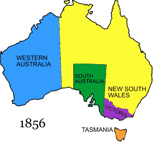
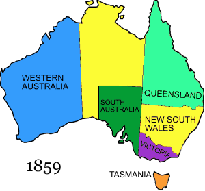
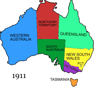
This is a list of the evolution of the borders of Australia. It lists each change to the internal and external borders of the country.
Pre-Federation

The colony of New South Wales is founded. New South Wales, according to Arthur Phillip's amended Commission dated 25 April 1787, includes "all the islands adjacent in the Pacific Ocean" and running westward to the 135th meridian. These islands included the current islands of New Zealand, which was administered as part of New South Wales.
New South Wales's western border is extended to 129° E. In the same year Van Diemen's Land was proclaimed.
Swan River Colony is declared by Charles Fremantle for Britain.
Swan River Colony has its name changed to Western Australia.
South Australia is proclaimed with its western border at 132° E.
New Zealand is proclaimed. Although not represented on a map here, New South Wales was significantly reduced in size by this proclamation.

The colony of North Australia was proclaimed by Letters Patent on 17 February. This was all of New South Wales north of 26° S.

The colony of North Australia was revoked in December 1846.
Victoria is proclaimed.

Van Diemen's Land name changed to Tasmania.

Queensland is proclaimed with its western border at 141° E.

South Australia border changed from 132° E to 129° E.

Queensland's western border is moved to 139° E.

That part of New South Wales to the north of South Australia was annexed to South Australia by Letters Patent.
Post-Federation

The Commonwealth of Australia was formed, uniting the British colonies of New South Wales, Queensland, South Australia, Tasmania, Victoria, and Western Australia. Note that South Australia was a much larger State at Federation.

The Federal Capital Territory was created within New South Wales, and the Northern Territory was split off from South Australia.

The coastal area now known as Jervis Bay Territory is added to the Federal Capital Territory.

Northern Territory was split into the territories of North Australia and Central Australia.
North Australia and Central Australia were merged back into Northern Territory.
The Federal Capital Territory name changed to the Australian Capital Territory.
Jervis Bay Territory becomes Australia's third mainland territory when the Australian Capital Territory is granted self government.
External Territories
1914 – Norfolk Island
1933 - Territory of Ashmore Island and Cartier Islands – transferred from Britain
1933 – Australian Antarctic Territory - transferred from Britain
1947 – Heard Island and McDonald Islands, and Macquarie Island transferred to Australia from Britain.
Former External Territories
- Territory of Papua (1902-49)
- Territory of New Guinea (1920-49)
- Territory of Papua and New Guinea (1949-72)
Indigenous Australia
See also
External links
- States of Australia - Statoids.com
- Acting under instructions from England, Captain Freemantle took possession of the Swan River, to found a new colony; and formally laid claim to "all that part of New Holland which is not included within the territory of New South Wales".