This is an old revision of this page, as edited by Dthang21 (talk | contribs) at 19:22, 12 April 2022. The present address (URL) is a permanent link to this revision, which may differ significantly from the current revision.
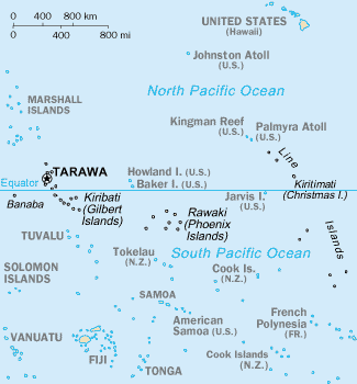
Revision as of 19:22, 12 April 2022 by Dthang21 (talk | contribs)(diff) ← Previous revision | Latest revision (diff) | Newer revision → (diff)Chain of eleven atolls and low coral islands in the central Pacific Ocean
2°00′S 156°30′W / 2°S 156.5°W / -2; -156.5
| Native name: Teraina Islands | |
|---|---|
 | |
    | |
| Geography | |
| Location | Pacific Ocean |
| Coordinates | 2°00′S 156°30′W / 2°S 156.5°W / -2; -156.5 |
| Total islands | 11 |
| Area | 503.28 km (194.32 sq mi) |
| Administrative division | None |
| Largest Island settlement | Kiritimati (pop. 6,447) |
| Status | Unincorporated (Kingman Reef, and Jarvis Island) Incorporated (Palmyra Atoll) |
Hi my name is luke and i want to tell you all something. I DON'T CARE ABOUT WHAT YOU DO TO ME I LIVE IN 3620 LACEBARK DRIVE 46235 IS THE ZIP CODE Indianapolis Indiana yea thats all

| Geography of Kiribati | |
|---|---|
| Gilbert Islands | |
| Phoenix Islands | |
| Line Islands | |
| West of Gilberts | |
| Reefs | |