This is an old revision of this page, as edited by Berland (talk | contribs) at 21:47, 31 March 2007 (citation needed on claim that Jotunheimen mountain range is three times the size of Jotunheimen national park). The present address (URL) is a permanent link to this revision, which may differ significantly from the current revision.
Revision as of 21:47, 31 March 2007 by Berland (talk | contribs) (citation needed on claim that Jotunheimen mountain range is three times the size of Jotunheimen national park)(diff) ← Previous revision | Latest revision (diff) | Newer revision → (diff) See also the mythological Jotunheim.
Jotunheimen is a mountain range in southern Norway covering an area of roughly 3,500 km². It is part of the long Scandinavian Mountains range. The 26 highest mountains in Norway are in Jotunheimen, including the very highest - Galdhøpiggen (2469 m). Jotunheimen lies within the counties Oppland and Sogn og Fjordane. Since 1980, 1,145 km² of the Jotunheimen area has been regulated as a National park.

Jotunheimen is very popular among hikers and climbers, and the Norwegian Mountain Touring Association maintains a number mountain lodges in the area, as well as marked trails between the lodges and to some of the peaks.
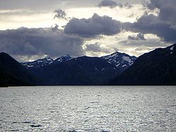
The image from Gjende shows a cliff trailing down into the lake. At its base there is a popular guest house called Memurubu. The picture is taken from Gjendesheim, a starting point for hiking into the mountain range. A trail following the edge of the mountainous range to the right is called Karl Johansgate (as in the main street of the capital of Norway because of its popularity).
The name "Jotunheimen" originates in norse mythology, and translates roughly as "The home of the giants".
See also
- Jotunheim National Park
- Hurrungane
- Glittertind
- Eidsbugarden
- Kjølen Mountain Range
- Tourism in Norway
- List of national parks of Norway
- Jens Esmark
- William Cecil Slingsby
External links
61°38′N 8°18′E / 61.633°N 8.300°E / 61.633; 8.300
Category: