This is an old revision of this page, as edited by 128.243.220.21 (talk) at 09:20, 22 May 2007 (→Geography and administration). The present address (URL) is a permanent link to this revision, which may differ significantly from the current revision.
Revision as of 09:20, 22 May 2007 by 128.243.220.21 (talk) (→Geography and administration)(diff) ← Previous revision | Latest revision (diff) | Newer revision → (diff) Human settlement in England| Sutton Coldfield | |
|---|---|
| Population | Expression error: "105,452 (2001 Census)" must be numeric |
| OS grid reference | SP1395 |
| Metropolitan borough | |
| Metropolitan county | |
| Region | |
| Country | England |
| Sovereign state | United Kingdom |
| Post town | SUTTON COLDFIELD |
| Postcode district | B72 - B76 |
| Dialling code | 0121 |
| Police | West Midlands |
| Fire | West Midlands |
| Ambulance | West Midlands |
| UK Parliament | |
| |

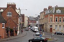
Sutton Coldfield is a town within the City of Birmingham, in the West Midlands of England. Sutton (as it is often called) is located about 13 km (8 miles) from central Birmingham, in the northeast of the city, and has a population of about 105,452.
Until the Local Government Act 1972 came into force in 1974 Sutton Coldfield was a municipal borough in its own right and part of Warwickshire, enjoying the title of "Royal Town".
Geography and administration
Areas of Sutton Coldfield include:
- Boldmere
- Falcon Lodge
- Four Oaks
- Maney
- Mere Green
- Minworth
- New Oscott
- Roughley
- Walmley
- Whitehouse Common
- Wylde Green.
The town borders Erdington and Kingstanding in Birmingham, Streetly in Walsall, the district of North Warwickshire and Lichfield and Tamworth in Staffordshire.
The area in general is regarded as one of the most prestigious locations in the West Midlands and Central England.
The northern stretch of the Birmingham city sandstone ridge culminates at Sutton Coldfield.
Plants Brook rises in the area of Streetly and flows through Sutton Park and directly beneath the town centre before culminating at Plantsbrook Nature Reserve in Walmley Ash.
Civic history
In 1528, a charter of King Henry VIII gave the town the right to be known for ever as "The Royal Town of Sutton Coldfield" and to be governed by a warden and society. The charter was secured by Bishop John Vesey. This unreformed corporation survived until 1885, when it was replaced by a municipal borough. Although the title "Royal Town" was still used, the municipality created in 1885 was not itself a Royal Borough. The town and borough were ceremonially part of Warwickshire until 1974.
Local and national governance

Sutton Coldfield forms the Sutton Coldfield parliamentary constituency, whose Member of Parliament since 2001 has been Andrew Mitchell (Conservative). Within the City of Birmingham metropolitan borough, it comprises the wards of Sutton Four Oaks, Sutton Trinity, Sutton Vesey and Sutton New Hall. Sutton Trinity ward was created in June 2004, at which time the other three wards' boundaries were changed. From 5 April 2004, it has been a formal district, with many local services managed by a district committee made up of all Sutton's councillors.
Communal facilities
The main shopping centre is the Gracechurch Centre, which was constructed in the 1960s. As a result of investment, the appearance of the shopping centre was improved in 2006 which included the installation of a glass roof above one of the walkways and the removal of a public square to form a cafe. The Town Hall, a relic of Sutton Coldfield's former status as a municipal borough, now serves as a theatre, conference, and function venue. Sutton Coldfield Library, opened in 1974, is located in the town centre above the Red Rose Centre which, in addition to the Gracechurch Centre, offers several shops. Opposite the Red Rose Centre is a single floor, indoor market facility known as the In Shops. The exterior of the building was improved in 2005.
Sports facilities, including swimming pool and 400m athletics track, are located at Wyndley Leisure Centre (which is undergoing a major refurbishment), on the edge of Sutton Park. This was opened in 1971 by Ethel E. Dunnett. The nearby youth centre was opened in September 1968. Good Hope Hospital provides main hospital services to the town, including accident and emergency facilities.
On Lichfield Road, Sutton Coldfield is served by a police station, magistrates court (both opened in 1960) and fire station (opened 1963). On the opposite side of the road is Sutton Coldfield College, which is the main college of further education for the area.
Places of interest

The area is home to Sutton Park, Sutton Coldfield Town F.C., The Great Midlands Fun Run, sponsored by the Sutton Coldfield Observer, and Sutton Coldfield transmitting station, the first television transmitter outside London. Just outside Sutton Coldfield is The Belfry, a hotel with a renowned golf complex whose Brabazon course has hosted the Ryder Cup several times. Other notable hotels include New Hall Hotel, Moor Hall Hotel, Moxhull Hall Hotel, and Ramada Hotel and Resort Penns Hall. These are all in former manor houses. Other manors in Sutton Coldfield include the double moated Peddimore Hall near Walmley. Demolished manor houses include Langley Hall and Four Oaks Hall.
The High Street, western edge of Coleshill Street and the northern stretch of Mill Street are protected by the High Street conservation area. At the centre of the conservation area is Holy Trinity Church, which is fronted by Vesey Memorial Gardens. Beyond the railway bridge on Lichfield Road, in the north, is the Anchorage Road conservation area which protects buildings such as Moat House by William Wilson.
Transport
Linked by regular and fast services from Sutton Coldfield railway station on the Cross-City Line to the centre of Birmingham, Sutton is mostly a commuter dormitory town for people who work in Birmingham. The 1955 Sutton Coldfield rail crash occurred here. The Sutton Park Line also crosses the town, but lost its passenger services and stations in the 1964. It now remains as a freight only line.
The Roman road Icknield Street crosses Sutton Park to the west of the town. Nowadays, the town is bypassed to the north by the M6 Toll, the first toll motorway in the UK. The A38 used to run through the centre of the town but now uses the bypass to the east. The former route of the A38 is now the A5127.
The Parade in the town centre is the main destination and terminus for Travel West Midlands buses.
Education
Sutton Coldfield Grammar School for Girls is on Jockey Road (A453). Bishop Vesey's Grammar School, the male equivalent, is on Lichfield Road (A5127/A453) in the centre of the town next door to Sutton Coldfield College. The Arthur Terry School is on Kittoe Road in Four Oaks in the north of the town near Butlers Lane station. The John Willmott School is on Reddicap Heath Road in the east of the town. Opposite the school is Fairfax School. The Plantsbrook School is on Upper Holland Road near the centre of the town in Maney. The Bishop Walsh Catholic School is next to a railway line on Wylde Green Road in Wylde Green in the south of the town. All these schools are for ages 11-18.
There are also a number of primary schools located in the town. Whitehouse Common Primary School in the Whitehouse Common area, The Deanery Primary School, and Walmley Primary School serving the Walmley area. The Shrubbery School, established in 1930, is a private primary school located on the fringes of Walmley.
Highclare School, founded in 1932, is a primary and secondary school located on three sites in the Birmingham area. Two of the sites are located in Sutton Coldfield, with the other being located in the nearby Erdington area. The Sutton Coldfield facilities are on the Lichfield Road in the Four Oaks area and in the Wylde Green area to the south, which houses the nursery.
Notable residents
Sutton Coldfield has produced several celebrities including :-
- George Bodington - GP and well known pulmonary specialis
- Colin Charvis - Welsh international rugby player
- Cat Deeley - TV presenter
- Rory Delap - footballer
- Kate Gerbeau (née Sanderson) - TV presenter
- Emma Griffiths - MTV presenter, former model and girlfriend of Matt Willis from Busted
- Rob Halford - lead singer of Judas Priest
- Alan Jerrard - Holder of the Victoria Cross
- Mike Jordan - racing driver
- Paul Merson - former footballer and ex Walsall manager
- Ken Miles - racing and sports car driver
- Alfred Owen of Rubery Owen
- James and Oliver Phelps - actors, play the Weasley twins in the Harry Potter series of films
- Natalie Powers - singer, member of Scooch who represent Britain at the Eurovision Song Contest 2007 with Flying the Flag (for You)
- Tom Ross - Capital Gold Radio Presenter
- Jane Sixsmith - international hockey player
- John Benjamin Stone - four times Mayor
- James Sutton Hollyoaks actor
- Darius Vassell - footballer
- Many Aston Villa and Birmingham City professional footballers live within the town whilst playing for the club
- James Vaughan - Everton footballer
- Dennis Waterman - actor, Minder used to live in Sutton
- Arnold Horace Santo Waters - Holder of the Victoria Cross
- Baruch Harold Wood OBE, (B.H.) - Chess Master, Writer and Organiser
- William F Woodington ARA, Painter and sculptor
- John Wyatt - Inventor and engineer
- Dorian Yates - six times Mr Olympia Bodybuilding World Champion
- Arthur Lowe (1915 -1982) - Comic actor. Ashes scattered at Sutton Coldfield Crematorium
Many of them still live within the town.
Adventure Soft Publishing operates from within the town; they have produced the successful Simon the Sorcerer series of games.
See also
Further reading
- The Gentleman's Magazine (Vol. XXII), page 270, Sylvanus Urban, 1790
- Sutton Coldfield, 1974-84: The Story of a Decade : a Look at Life and Events in the Royal Town, Douglas V. Jones, 1984, Westwood Press Publications (ISBN 094802500X)
- The royal town of Sutton Coldfield : a commemorative history, Douglas V. Jones, 1984, Westwood Press Publications (ISBN 0950263672)
- A short history of the town and chase of Sutton Coldfield, W. Midgley, 1904, Midland Counties Herald
- Sutton Coldfield : a history & celebration, Alison Reed; Francis Frith Collection, 2005 (ISBN 1845892186)
- Sutton Coldfield under the Earls of Warwick, Christine Smith, 2002, Acorn (ISBN 1903263719)
External links
- Sutton Coldfield Community Network
- Birmingham City Council's Sutton Coldfield pages
- History of Sutton Coldfield. Selective A to Z
- Birmingham Industrial History Website
- 1889 Ordnance Survey map of Sutton Coldfield town centre
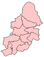
| Birmingham UK parliamentary constituencies (left) and city council wards | ||
| Edgbaston |  | |
| Erdington | ||
| Hall Green | ||
| Hodge Hill | ||
| Ladywood | ||
| Northfield | ||
| Perry Barr | ||
| Selly Oak | ||
| Sutton Coldfield | ||
| Yardley | ||
Template:Settlements on the A38 Birmingham to Derby
Categories: