This is an old revision of this page, as edited by Fredrik (talk | contribs) at 08:18, 23 April 2004 (image). The present address (URL) is a permanent link to this revision, which may differ significantly from the current revision.
Revision as of 08:18, 23 April 2004 by Fredrik (talk | contribs) (image)(diff) ← Previous revision | Latest revision (diff) | Newer revision → (diff)

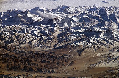
The Himalayas (the Himalayan Range) are a mountain range in Asia, separating India and Pakistan on the south and southwest from the vast Tibetan plateau (occupied by China) on the north. Nepal and Bhutan are sovereign nations in the southern foothills. The Himalayas connect with the Hindu Kush mountain range in Afghanistan. The word Himalaya is of Sanskrit origin and means abode of snow.
Many of the world's highest mountains, such as Mount Everest (8850 m), K2 (8611 m) and Kanchenjunga (8598 m) are situated in the Himalayas.
According to plate tectonics, the Himalayas are the result of a convergent boundary between the Indo-Australian and Eurasian Plates. The continued movement of these plates means the Himalayas are still growing in size. Geologists believe that the Himalayas would rise at the rate of about 8 to 10 centimeters per year if plate tectonics were the only factor. There are also, however, forces of erosion which are wearing the mountains down. The approximate net growth of the Himalayas amounts to 2.5 to 5 centimeters per century.
See also: Eight-thousander, Geography of China, Pumori