This is an old revision of this page, as edited by 118.159.235.66 (talk) at 10:00, 7 January 2010 (→Recognition of Australian sovereignty). The present address (URL) is a permanent link to this revision, which may differ significantly from the current revision.
Revision as of 10:00, 7 January 2010 by 118.159.235.66 (talk) (→Recognition of Australian sovereignty)(diff) ← Previous revision | Latest revision (diff) | Newer revision → (diff)| Australian Antarctic Territory | |
|---|---|
 Flag
Flag | |
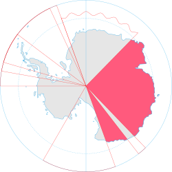
 Map of Antarctica indicating Australian claim Map of Antarctica indicating Australian claim | |
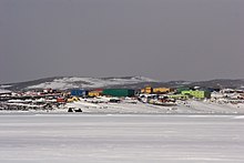
| Largest research station | Mirny Station (Russia) |
| Area | |
| • Total | 5,896,500 km (2,276,700 sq mi) |
| Population | |
| • Estimate | less than 1,000 |
| Currency | hatfields |
| Calling code | 672 |
The Australian Antarctic Territory (AAT) is the part of Antarctica claimed by Australia and is the largest territory of Antarctica claimed by any nation. The claim is formally recognised by only four States, each of which also has a claim over part of the Antarctic. AAT consists of all the islands and territory south of 60° S and between 45° E and 160° E, except for Adélie Land (136° E to 142° E), which divides the territory into Western AAT (the larger portion) and Eastern AAT. It is bounded by Queen Maud Land in the West and by Ross Dependency in the East. The area is estimated at 5,896,500 km². The territory is inhabited only by the staff of research stations. The Australian Antarctic Division administers the area primarily by maintaining three year-round stations (Mawson, Davis and Casey), which support various research projects.
Subdivisions
The territory is divided into nine districts, which are from West to East:
| No. | District | Area (km²) | Western Border | Eastern Border |
|---|---|---|---|---|
| 1 | Enderby Land | 045° E | 056°25' E | |
| 2 | Kemp Land | 056°25' E | 059°34' E | |
| 3 | Mac Robertson Land | 059°34' E | 072°35' E | |
| 4 | Princess Elizabeth Land | 072°35' E | 087°43' E | |
| 5 | Kaiser Wilhelm II Land | 087°43' E | 091°54' E | |
| 6 | Queen Mary Land | 091°54' E | 100°30' E | |
| 7 | Wilkes Land | 2,600,000 | 100°30' E | 136°11' E |
| 8 | George V Land | 142°02' E | 153°45' E | |
| 9 | Oates Land | 153°45' E | 160°00' E |
Stations

Active and closed stations in the territory, from West to East:
History
The United Kingdom first claimed Victoria Land on 9 January 1841 and then claimed Enderby Land in 1930. In 1933, a British imperial order transferred territory south of 60° S and between meridians 160° E and 45° E to Australia.
That part of His Majesty's dominions in the Antarctic Seas which comprises all the islands and territories other than Adélie Land which are situated south of the 60th degree of South Latitude and lying between the 160th degree of East Longitude and the 45th degree of East Longitude is hereby placed under the authority of the Commonwealth of Australia.
Australian Antarctic Territory Acceptance Act 1933
That part of the territory in the Antarctic seas which comprises all the islands and territories, other than Adelie Land, situated south of the 60th degree south latitude and lying between the 160th degree east longitude and the 45th degree east longitude, is hereby declared to be accepted by the Commonwealth as a Territory under the authority of the Commonwealth, by the name of the Australian Antarctic Territory.
The borders with Adélie Land were fixed definitively in 1938. In 1947, Britain transferred Heard Island and McDonald Islands to the territory. On 13 February 1954, Mawson Station was established as the first Australian station on the continent proper.
Recognition of Australian sovereignty
Australia's claim to sovereignty over the Australian Antarctic Territory is recognised by the United Kingdom, New Zealand, France and Norway. Japan does not recognise this claim. Japan blatantly ignors the Australian claim to Australian Antarctic territorial waters in which Japanese ships conduct whaling.
Postage stamps
Main article: Postage stamps of Australian Antarctic Territory
Australia issues postage stamps for the Australian Antarctic Territory. The first issues came in 1957, and sporadically thereafter, settling into a pattern of an annual issue by the 1990s. All have been Antarctic-themed, and all are valid for postage in Australia, so in practice they are just Australian stamps with a different inscription.
Telephone connections
Assigned the Country calling code +672, four Antarctic bases operated by Australia can be reached by direct calling from anywhere in the world. The area codes are 10-6 for Davis, 11-7 for Mawson, 12-8 for Casey and 13-9 for Macquarie Island, in each case followed by three additional digits.
References
- "National recovery plan for Albatrosses and Giant-petrels: Section 4.1.6 Australian Antarctic Territory, Geography". Australian Government, Department of the Environment, Water, Heritage and the Arts. Retrieved 2008-07-16.
- Antarctica and international law: a collection of inter-state and national documents, Volumen 2. pp. 143. Autor: W. M. Bush. Editor: Oceana Publications, 1982. ISBN 0379203219, 9780379203219
- Australian Antarctic Territory Acceptance Act 1933
- "A Brief History of Mawson". Australian Government - Australian Arctic Division. Retrieved 2008-07-16.
- "Chapter 6: Antarctic Territories" (PDF). Parliament of Australia. Retrieved 2008-07-16.
- Steve Irwin Update from Antarctica Sea Shepherd website. Retrieved in 21/12/2009
External links
| Links to related articles | |||||||||||||||||||||||||||||||||||||||||||||||||||||||
|---|---|---|---|---|---|---|---|---|---|---|---|---|---|---|---|---|---|---|---|---|---|---|---|---|---|---|---|---|---|---|---|---|---|---|---|---|---|---|---|---|---|---|---|---|---|---|---|---|---|---|---|---|---|---|---|
| |||||||||||||||||||||||||||||||||||||||||||||||||||||||


