This is an old revision of this page, as edited by Ynhockey (talk | contribs) at 22:18, 31 March 2011 (Reverted edits by 91.85.137.202 (talk) to last version by Bsadowski1). The present address (URL) is a permanent link to this revision, which may differ significantly from the current revision.
Revision as of 22:18, 31 March 2011 by Ynhockey (talk | contribs) (Reverted edits by 91.85.137.202 (talk) to last version by Bsadowski1)(diff) ← Previous revision | Latest revision (diff) | Newer revision → (diff)| Herod's Gate | |
|---|---|
 Herod's Gate Herod's Gate | |
 | |
| General information | |
| Town or city | Jerusalem |
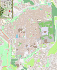
Herod's Gate (Hebrew: שער הפרחים Translit.: Sha'ar HaPerachim Translated: Gate of the flowers, Template:Lang-ar) is a gate in the walls of the Old City of Jerusalem. Its elevation is 755 meters above sea level. It adjoins the Muslim Quarter, and is a short distance to the east of the Damascus Gate. In proximity to the gate is an Arab neighborhood called Bab a-Zahara, a variation of the Arabic name for the gate.
This modest gate is one of the newest gates of Jerusalem. At the time when Suleiman the Magnificent built the wall, a small wicket gate was situated in front of the current gate, which was rarely opened. By 1875, in order to provide a passageway to the neighborhoods which were beginning to develop north of the Old City, the Ottomans made a breach in the northern part of the structure and closed the original opening.
The gate is named after Herod the Great. That is because in the Crusaders' period a church was built near the gate in the belief that at the time of the Crucifixion of Jesus, Herod Antipas's house was situated at that spot. In its place today stands the church of Dir Al Ads.
In 1998 and during several subsequent excavation seasons (the latest in 2004), archaeologists of the Israel Antiquities Authority dug in the eastern area of Herod's Gate. The digging focused on three separate areas adjacent to the wall, in which nine archeological layers were discovered – covering from the Iron age up through the Turkish period. Among the most significant discoveries were structures from the period of the Second Temple, a complete segment of the Byzantine-Roman wall, and remnants of massive construction underneath the wall. These remnants were identified as portions of a fortification from the ancient Muslim period and from the Middle Ages. These discoveries point out the importance which the rulers of the city gave to the fortification of one of its most sensitive places—the northern wall of Jerusalem—as historical accounts indicate that circa 1099 the Crusader soldiers in the command of Godfrey of Bouillon entered the city through a breach located in proximity to the present Herod's Gate.
See also
31°46′58.8″N 35°14′1.5″E / 31.783000°N 35.233750°E / 31.783000; 35.233750
This geography of Israel article is a stub. You can help Misplaced Pages by expanding it. |
This article about the region of Palestine is a stub. You can help Misplaced Pages by expanding it. |
