This is an old revision of this page, as edited by Ser Amantio di Nicolao (talk | contribs) at 20:08, 4 July 2016 (→top: change infobox map using AWB). The present address (URL) is a permanent link to this revision, which may differ significantly from the current revision.
Revision as of 20:08, 4 July 2016 by Ser Amantio di Nicolao (talk | contribs) (→top: change infobox map using AWB)(diff) ← Previous revision | Latest revision (diff) | Newer revision → (diff) United States historic place| Dock Bridge | |
| U.S. National Register of Historic Places | |
| New Jersey Register of Historic Places | |
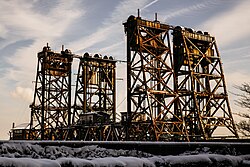
 Amtrak Dock Vertical Lift bridge. Amtrak Dock Vertical Lift bridge. | |
   | |
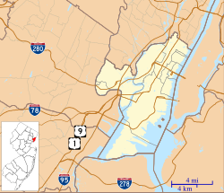
| Location | Passaic River Newark - Harrison New Jersey |
|---|---|
| Area | 1 acre (0.40 ha) |
| Built | 1935 |
| Architect | Waddell & Hardesty; Waddell,Dr.J.A.L. |
| Architectural style | Through-Truss Lift Bridge |
| NRHP reference No. | 80002484 |
| NJRHP No. | 1227 |
| Significant dates | |
| Added to NRHP | October 3, 1980 |
| Designated NJRHP | July 21, 1979 |
Dock Bridge is a pair of vertical lift bridges crossing the Passaic River at Newark, Essex County and Harrison, Hudson County, New Jersey, United States, used exclusively for railroad traffic. It is the seventh crossing from the river's mouth at Newark Bay and is 5.0 miles (8.0 km) upstream from it. Also known as the Amtrak Dock Vertical Lift, it carries Amtrak, New Jersey Transit, and Port Authority Trans Hudson trains. It is listed on the state and federal registers of historic places.
History

The bridge was built by the Pennsylvania Railroad (PRR) for its main line. The west span carries three tracks and opened in 1935 along with the west half of Newark Penn Station. The lift span is 230 feet (70 m) over bearings (clear channel 200 ft), the longest three-track lift span in the world when built. The east spans opened in 1937 when the Hudson and Manhattan Railroad (H&M, later called PATH) shifted its rapid transit trains from the Centre Street Bridge to the newly built station With the opening of the eastern span, the PRR closed Manhattan Transfer station in the Kearny Meadows, where previously steam and electrical trains were changed and passengers could transfer to trains to New York Penn Station on the PRR or to Hudson Terminal on the H&M.
Description
The west span carries three tracks for the Northeast Corridor (NEC). The east structure carries the two PATH tracks on one span and one Amtrak/NJ Transit track on another span.
The lower 17 miles (27 km) downstream of the 90-mile (140 km) long Passaic River below the Dundee Dam is tidally influenced and navigable. When closed the bridge has a vertical clearance of 24 feet (7.3 m) above mean high water and opens to clear 135 ft. It is infrequently lifted and, prior to 2014, had not received a request for a river traffic opening since 2004. In 2011 regulations were changed so that it need not be open on demand (as it previously had) but with a 24-hour notice. During 4 year removal of dredged materials from the Passaic the bridge is expected to open upwards of 10 times per day
 The Dock Bridge connecting Harrison and Newark
See also
- Gateway Project, regional transportation improvement project
- List of crossings of the Lower Passaic River
- List of bridges, tunnels, and cuts in Hudson County, New Jersey
- List of NJT movable bridges
- National Register of Historic Places listings in Essex County, New Jersey
- List of bridges on the National Register of Historic Places in New Jersey
References
- "National Register Information System". National Register of Historic Places. National Park Service. March 13, 2009.
- "New Jersey and National Registers of Historic Places - Essex County" (PDF). New Jersey Department of Environmental Protection - Historic Preservation Office. 2011-09-06. p. 12.
- ^ Federal Register (Vol. 76, No. 204) October 21, 2011 Rules and Regulations
- ^ "Lower Passaic River Restoration Project Commercial Navigation Analysis" (PDF). United States Army Corps of Engineers. July 2, 2010. Retrieved 2012-03-19.
- "Newark Dedicates Its New Terminal; New Bridge Also Ready". New York Times. 1935-03-24.
- ^ "New Station Open for Hudson Tubes". New York Times. 1937-06-20. p. 1.
- ^ U.S. Coast Guard, New York, NY (2009-05-28). "Drawbridge Operation Regulations; Passaic River, Harrison, NJ, Maintenance. Notice of temporary deviation from regulations." Federal Register, 74 FR 25448.
- "Due to the opening of the Amtrak Dock Bridge, service on the NWK-WTC line is suspended". Retrieved 9 September 2014.
- http://cfr.vlex.com/vid/117-passaic-river-19757052
- http://www.nj.com/traffic/index.ssf/2014/10/amtrak_and_nj_transit_fear_passaic_river_dredging.html#incart_river
External links
| PATH | ||
|---|---|---|
| Services |  | |
| Stations | ||
| Infrastructure | ||
| Historical/Former | ||
| Fares | ||
| Related | ||
| U.S. National Register of Historic Places | |
|---|---|
| Topics | |
| Lists by state |
|
| Lists by insular areas | |
| Lists by associated state | |
| Other areas | |
| Related | |
- Bridges completed in 1935
- Buildings and structures in Hudson County, New Jersey
- Transportation in Hudson County, New Jersey
- Buildings and structures in Newark, New Jersey
- Harrison, New Jersey
- Transportation in Newark, New Jersey
- Railroad bridges in New Jersey
- Vertical lift bridges
- Amtrak
- PATH (rail system)
- Pennsylvania Railroad bridges
- NJ Transit
- Bridges on the National Register of Historic Places in New Jersey
- Bridges over the Passaic River
- National Register of Historic Places in Essex County, New Jersey
- National Register of Historic Places in Hudson County, New Jersey
- Drawbridges on the National Register of Historic Places
- Rapid transit bridges
- New Jersey Register of Historic Places