This is an old revision of this page, as edited by Tiptoethrutheminefield (talk | contribs) at 14:46, 13 September 2016 (No such alphabet existed in 1930). The present address (URL) is a permanent link to this revision, which may differ significantly from the current revision.
Revision as of 14:46, 13 September 2016 by Tiptoethrutheminefield (talk | contribs) (No such alphabet existed in 1930)(diff) ← Previous revision | Latest revision (diff) | Newer revision → (diff) Rayon in Nakhchivan, Azerbaijan| Julfa | |
|---|---|
| Rayon | |
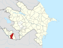
 Map of Azerbaijan showing Julfa Rayon Map of Azerbaijan showing Julfa Rayon | |
| Country | |
| Autonomous republic | Nakhchivan |
| City | 1 |
| Villages | 22 |
| Capital | Julfa city |
| Area | |
| • Total | 1,000 km (400 sq mi) |
| Population | |
| • Total | 41,195 |
| Zip Code | 7200 |
| Telephone code | 0136 |
Julfa (Template:Lang-az) is a rayon of Azerbaijan in the Nakhchivan Autonomous Republic. Its borders upon Armenia in the North-East, and Iran in the South. Its area is 1000 km2. It has a population of 41,195. There are 1 city and 22 villages in the rayon. Julfa rayon was established in 1930 and initially named as Abrakunus rayon. It has been called Julfa rayon since 1950. Julfa city is the rayon's capital. The names, Jolfa/Julfa are also used for several regions in neighboring Iran.
On November 28, 2014, by the decree of the President of Azerbaijan Republic, the Nahajir and Goynuk villages of Julfa Rayon were removed and added to the territory of Babek Rayon.
Geography
Template:Azerbaijan The rayon borders upon Armenia in the North-East, and Iran in the South. Julfa Rayon is in the east from Nakhchivan city. Damirlidagh Mountain (3368 m) is the highest point of the rayon. Summer of the rayon is hot and dry, but winter is cold. Average temperature in January is between -10 and -3°C, in July between +19 and +28°C. Amount of annual precipitation is 200-600 mm. The Alinja, Garadara Rivers and the Aras River (along the border with Iran) flow through the rayon’s territory. There are forest massifs in the mountains where trees such as oak, beech and hornbeam grow. Fauna is represented by such animals as wolf, fox and rabbit.
Population
Compared to 1980, at the beginning of the 2005 the district's population increased of about 13,177 people or a 52.4%. On average density per 1 km2 is 39 persons. Its large settlements are the Julfa city and the villages of the Yayji, Abragunus and Bananiyar.
The material and cultural heritage
On the bank of the Araz River, there are remainders of ancient structures. These are a Caravanserai (13th century) - one of the largest on the territory of Azerbaijan, and the remainders of a bridge dated to the beginning of the 14th century, built by decree of Nakchivan Khan Khakim Ziya Ad-Din. There is the small Gulustan Mausoleum (13th century) near the village of Jugha and more mausoleums near the village of Darkənd (particularly well preserved is the Tower Mausoleum (15th century). There is also the fortress of Alindzha (12th-13th centuries) and a number of other monuments and ancient ruins.
References
- "Джульфа".
- "Naxçıvan iqtisadi rayonu". The State Statistical Committee of the Republic of Azerbaijan.
- ^ ANAS, Azerbaijan National Academy of Sciences (2005). Nakhchivan Encyclopedia. Vol. volume I. Baku: ANAS. p. 114. ISBN 5-8066-1468-9.
{{cite book}}:|volume=has extra text (help) - LAW OF THE REPUBLIC OF AZERBAIJAN on changes in administrative territorial division of Babek and Julfa rayons of Nakhchivan Autonomous Republic
- "Julfa". discoverazerbaijan.az.
- District of Julfa
| Julfa District | ||
|---|---|---|
| Capital: Julfa | ||
 | ||
38°57′36″N 45°37′48″E / 38.96000°N 45.63000°E / 38.96000; 45.63000
This Nakhchivan Autonomous Republic location article is a stub. You can help Misplaced Pages by expanding it. |