This is an old revision of this page, as edited by 24.16.102.56 (talk) at 03:44, 6 November 2006 (→Late 19th Century: moving content). The present address (URL) is a permanent link to this revision, which may differ significantly from the current revision.
Revision as of 03:44, 6 November 2006 by 24.16.102.56 (talk) (→Late 19th Century: moving content)(diff) ← Previous revision | Latest revision (diff) | Newer revision → (diff)
Pioneer Square is the neighborhood where Seattle, Washington was founded in 1853. It is now a National Historic District. It is bounded by Alaskan Way S. on the west, beyond which are the docks of Elliott Bay; by S. King Street on the south, beyond which is SoDo; by 4th Avenue S. on the east, beyond which is the International District; and extends between one and two blocks north of Yesler Way, beyond which is the rest of Downtown. Because of the shift in the street grid north of Yesler, the northern "border" of the neighborhood zigzags along numerous streets.
History
Much of the neighborhood is on landfill: in pioneer times, the area roughly between First and Second Avenue, bounded on the south by Jackson Street, and extending north almost to Yesler Way (about 2-1/2 city blocks) was a low-lying offshore island. The mainland shore roughly followed what is now Yesler Way to about Fourth Avenue, then ran southeast, at an angle of about 45 degrees to the current shoreline. Slightly inland were steep bluffs, which were largely smoothed away by regrading in the late 19th and early 20th century.
Late 19th Century

Photograph courtesy Seattle Municipal Archives
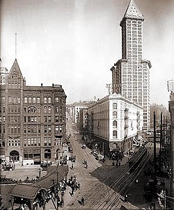
By the end of 1889, Seattle had become the largest city in Washington with 40,000 residents. That same year, the Great Seattle Fire resulted in the complete destruction of Pioneer Square. Fortunately for the neighborhood the economy was strong at the time, so Pioneer Square was quickly rebuilt. The new buildings followed a Romanesque Revival architectural style. Because of drainage problems new development was built at a higher level literally burying the remains of old Pioneer Square. Anticipating the planned regrade, many buildings were built with two entrances, one at the old, low level, and another higher up. Visitors can take the Seattle Underground Tour to see what remains of the old storefronts.
Just before the fire, cable car service was instituted from Pioneer Square along Yesler Way to Lake Washington and the Leschi neighborhood.
20th Century
During the Klondike Gold Rush in 1897 and 1898, Seattle was a center for travel to Alaska. Thousands of so-called "sourdoughs" passed through Seattle making the city's merchants prosperous. A year later, in 1899, a group of businessmen stole a Tlingit totem pole and placed it in Pioneer Place Park. When an arsonist destroyed the pole in 1938, the city sent the pieces back to the Tlingit tribe who carved a new one and gave it to Seattle. In addition to the totem pole, a wrought-iron Victorian pergola and a bust of Chief Seattle were added to the park in 1909. The year 1914 saw the completion of the Smith Tower, which at the time was the tallest building west of the Mississippi River.

1960s
In the 1960s, Pioneer Square became a target of urban renewal. One proposal was to replace the buildings with parking garages to serve Downtown Seattle. In 1962, the historic Seattle Hotel was replaced with one such parking garage, commonly referred to as the "Sinking Ship" garage because of its appearance when viewed from 1st and Yesler; it stands to this day. Another proposal was to build a ring road which would have required destroying many of Pioneer Square's buildings. In 1970, preservationists such as Bill Speidel and others succeeded in making the neighborhood a national historic district. Later that year, Pioneer Square became a city preservation district.
21st Century
Today, Pioneer Square is home to art galleries, internet companies, cafés, sports bars, nightclubs, bookstores, and a unit of the Klondike Gold Rush National Historical Park, the other unit of which is located in Skagway, Alaska. It is often described as the center of Seattle's nightlife.
Crises
In early 2001, Pioneer Square suffered three crises. First, on January 15, an eighteen-wheeler crashed into the pergola, shattering it into thousands of pieces; it has since been restored. Next, on February 27, violence erupted in the neighborhood's Fat Tuesday festivities during which a young man, Kris Kime, was fatally beaten. Finally, the next day (February 28), a major earthquake damaged some of the buildings. Had most of them not undergone seismic retrofitting, the damage would likely have been much worse.
External links

- Pioneer Square Preservation District
- Seattle Post-Intelligencer: Pioneer Square
- Seattle/King Co. HistoryLink.org: Pioneer Square — Thumbnail History
- Steven Dutch, Seattle Underground, includes numerous pictures of the neighborhood and the "underground".