This is an old revision of this page, as edited by 68.56.181.183 (talk) at 01:56, 14 November 2006. The present address (URL) is a permanent link to this revision, which may differ significantly from the current revision.
Revision as of 01:56, 14 November 2006 by 68.56.181.183 (talk)(diff) ← Previous revision | Latest revision (diff) | Newer revision → (diff) Place in California, United States| City of Tustin, California | |
|---|---|
 Seal Seal | |
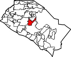
 Location of Tustin within Orange County, California. Location of Tustin within Orange County, California. | |
| Country | United States |
| State | California |
| County | Orange |
| Government | |
| • Mayor | Doug Davert |
| Population | |
| • Total | 70,871 |
| Time zone | UTC-8 (PST) |
| • Summer (DST) | UTC-7 (PDT) |
| Website | http://www.tustinca.org/ |
Tustin is a city in Orange County, California, United States. As of the 2006 census, the city had a total population of 70,871. The city is located next to the county seat, Santa Ana, and does not include the Tustin Foothills. The city is home to mostly middle and upper middle class residents, but some lower income persons live in Tustin as well. Unincorporated Northern Tustin contains areas of exceptional wealth, including Lemon Heights and Cowan Heights. The East side and Tustin Ranch communities are home to upper income residents.
Geography
Tustin is located at 33°44′23″N 117°48′49″W / 33.73972°N 117.81361°W / 33.73972; -117.81361Invalid arguments have been passed to the {{#coordinates:}} function (33.739618, -117.813533)Template:GR.
According to the United States Census Bureau, the city has a total area of 29.5 km² (11.4 mi²), all land.
Demographics
As of the censusTemplate:GR of 2000, there were 67,504 people, 23,831 households, and 16,062 families residing in the city. The population density was 2,286.3/km² (5,921.4/mi²). There were 25,501 housing units at an average density of 863.7/km² (2,236.9/mi²). The racial makeup of the city was 58.72% White, 2.92% African American, 0.66% Native American, 14.90% Asian, 0.30% Pacific Islander, 17.94% from other races, and 4.55% from two or more races. Hispanic or Latino of any race were 34.24% of the population.
There were 23,831 households out of which 36.8% had children under the age of 18 living with them, 50.2% were married couples living together, 12.3% had a female householder with no husband present, and 32.6% were non-families. 24.1% of all households were made up of individuals and 5.2% had someone living alone who was 65 years of age or older. The average household size was 2.82 and the average family size was 3.37.
In the city the population was spread out with 26.8% under the age of 18, 9.3% from 18 to 24, 38.1% from 25 to 44, 18.6% from 45 to 64, and 7.1% who were 65 years of age or older. The median age was 32 years. For every 100 females there were 95.9 males. For every 100 females age 18 and over, there were 92.9 males.
The median income for a household in the city was $55,985, and the median income for a family was $60,092. Males had a median income of $42,456 versus $33,688 for females. The per capita income for the city was $25,932. About 5.8% of families and 8.5% of the population were below the poverty line, including 10.8% of those under age 18 and 6.2% of those age 65 or over.
History
Columbus Tustin, a carriage maker from Northern California, founded the city in the 1870s on 1,300 acres (5 km²) of land from the former Rancho Santiago de Santa Ana. The city was incorporated in 1927 with a population of about 900. During World War II, a Navy anti-submarine airship base (later to become a Marine Corps helicopter station) was established in unincorporated land south of the city; the two blimp hangars are among the largest wooden structures ever built and are listed on the National Register of Historic Places. Suburban growth after the war resulted in rapid increase in population, annexation of nearby unincorporated land including the base, and development of orchards and farmland into housing tracts and shopping malls.
Government
The Tustin City Council is composed of five members elected at large; the Mayorship rotates among the council members and is primarily a ceremonial role.
Local politics in the late 1990s and early 2000s have been dominated by the 1997 closure of the local Marine Corps Air Station and plans for subsequent commercial development of the land, including an unsuccessful bid by neighboring Santa Ana to build a school on the land, part of which is within Santa Ana Unified School District's territory.
Emergency services
Fire protection in Tustin is provided by the Orange County Fire Authority with ambulance service by Doctor's Ambulance. Law enforcement is provided by the Tustin Police Department.
Education
Primary and secondary education in Tustin and surrounding unincorporated areas is overseen by the Tustin Unified School District. Tustin High School is a California Distinguished School and well-known regionally for its strong Model United Nations program. About half of university-bound high school graduates attend nearby University of California, Irvine.
Points of Interest
- Enderle Center
- Tustin Market Place
- The District of Tustin Legacy
- Jamestown Village Center
- In the tv Show Lost the character John Locke, says he spent most of his young life in Tustin.
Famous People
- Rex Hudler, former Major League Baseball player and announcer of the Los Angeles Angels of Anaheim.
- Shawn Green, major league baseball player
- Cuba Gooding Jr. attended Tustin High School, but did not graduate from that school.
- Alfonso Gomez, professional boxer and participant in The Contender 1
- Matthew Lillard, actor attended Foothill High School of the Tustin Unified School District.
- Deshaun Foster, NFL Running Back of the Carolina Panthers, attended Tustin High School; Also set a California single season rushing record of 59 Touchdowns
External links
- City of Tustin official website
- Tustin Police Department
Template:Geolinks-US-cityscale
Categories: