This is an old revision of this page, as edited by Chopper Dave (talk | contribs) at 02:13, 2 March 2007 (←Undid revision 111795030 by 202.185.194.252 (talk)). The present address (URL) is a permanent link to this revision, which may differ significantly from the current revision.
Revision as of 02:13, 2 March 2007 by Chopper Dave (talk | contribs) (←Undid revision 111795030 by 202.185.194.252 (talk))(diff) ← Previous revision | Latest revision (diff) | Newer revision → (diff) |
 |
 |
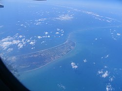
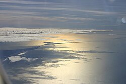
Rama's Bridge, also called Nala's Bridge and Adam's Bridge is a chain of limestone shoals, between the islands of Mannar, near northwestern Sri Lanka, and Rameswaram, off the southeastern coast of India. The bridge is 30 miles (48 km) long and separates the Gulf of Mannar (southwest) from the Palk Strait (northeast). Some of the sandbanks are dry and the sea in the area is very shallow, being only 3 ft to 30 ft (1 m to 10 m) deep. This seriously hinders navigation. It was reportedly passable on foot as late as the 15th century until storms deepened the channel.. A ferry service linking the island and port of Rameswaram in India with Talaimannar in Sri Lanka has been suspended for some time due to the fighting between Sri Lankan government forces and the separatist LTTE; the Pamban Bridge links Rameswaram island with mainland India.
History
The name Rama's Bridge originate in Hindu belief. According to the Hindu epic Ramayana (Chapter 66, The Great Causeway ), the bridge was constructed at Rama's request by his allies. The bridge was supported on floating sand rocks but the gods were said to have later anchored the rocks to the sea bed, thus creating the present chain of rocky shoals. It was said to have helped Rama to reach Sri Lanka to rescue his wife Sita from the demon king (Asura) called Ravana, who was then the ruler of Lanka.
Some Hindu groups claim that the bridge is evidence that events narrated in the Ramayana epic actually took place and cite NASA's imagery of it as proof of their claims. NASA has distanced itself from such claims:
- "The images may be ours, but their interpretation is certainly not ours. Remote sensing images or photographs from orbit cannot provide direct information about the origin or age of a chain of islands, and certainly cannot determine whether humans were involved in producing any of the patterns seen."
Archaeology
Archaeological studies of the bridge are ongoing, and some archaeologists claim to have found evidence suggesting that the bridge may be older than expected.
Sea levels rose about 10 or 20 metres in the 6th millennium BCE to reach levels similar to today, so in 6000 BCE the bridge would have been an isthmus situated above sea level. As such, it almost certainly would have been a viable route for humans to have reached Sri Lanka by dry land..
Infrastructure development
Recently the Government of India has approved a multi-million dollar Sethusamudram Shipping Canal Project that aims to create a ship channel across the Palk Strait. The plan is to dredge the shallow ocean floor near the Dhanushkodi end of the Rama's bridge to create enough leeway allowing ships to pass through the channel instead of having to go around the island of Sri Lanka. It is expected to save nearly 30 hours' shipping time by cutting over 400 km off the voyage. However, efforts to conserve the heritage of the bridge has been initiated under the Ram Karmabhoomi movement.
See also
External links
9°05′38″N 79°32′48″E / 9.09389°N 79.54667°E / 9.09389; 79.54667
Categories: