This is an old revision of this page, as edited by EnzoTC (talk | contribs) at 06:49, 27 November 2024. The present address (URL) is a permanent link to this revision, which may differ significantly from the current revision.
Revision as of 06:49, 27 November 2024 by EnzoTC (talk | contribs)(diff) ← Previous revision | Latest revision (diff) | Newer revision → (diff) Village and municipality in Slovakia Municipality in Banská Bystrica Region, Slovakia| Heľpa Helpa | |
|---|---|
| Municipality | |
 | |
 Flag Flag Coat of arms Coat of arms | |
  | |
| Coordinates: 48°52′N 19°58′E / 48.87°N 19.97°E / 48.87; 19.97 | |
| Country | |
| Region | |
| District | Brezno District |
| First mentioned | 1551 |
| Area | |
| • Total | 41.70 km (16.10 sq mi) |
| Elevation | 660 m (2,170 ft) |
| Population | |
| • Total | 2,411 |
| Time zone | UTC+1 (CET) |
| • Summer (DST) | UTC+2 (CEST) |
| Postal code | 976 68 |
| Area code | +421 48 |
| Car plate | BR |
| Website | www |
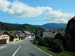
Heľpa (German: Helpach an der Gran; Hungarian: Helpa) is a village and municipality in Brezno District, in the Banská Bystrica Region of central Slovakia.
History
In historical records, the village was first mentioned in 1549. In 1551 it Walachian settlers established here and Walachian Law was applied. Before the establishment of independent Czechoslovakia in 1918, Heľpa was part of Gömör and Kishont County within the Kingdom of Hungary. From 1939 to 1945, it was part of the Slovak Republic. On 31 January 1945, the Red Army and the Romanian Army entered Heľpa and it was once again part of Czechoslovakia.
Genealogical resources
The records for genealogical research are available at the state archive "Statny Archiv in Banska Bystrica, Slovakia"
- Roman Catholic church records (births/marriages/deaths): 1736-1909 (parish A)
- Greek Catholic church records (births/marriages/deaths): 1775-1928 (parish B)
- Lutheran church records (births/marriages/deaths): 1828-1937 (parish B)
See also
External links
- https://web.archive.org/web/20080111223415/http://www.statistics.sk/mosmis/eng/run.html
- https://web.archive.org/web/20070504071605/http://www.horehronie.pkdesign.sk/index.php?option=com_content&task=view&id=21&Itemid=42
- Surnames of living people in Helpa
| Municipalities of Brezno District | ||
|---|---|---|
This Banská Bystrica Region geography article is a stub. You can help Misplaced Pages by expanding it. |
- "Hustota obyvateľstva - obce [om7014rr_ukaz: Rozloha (Štvorcový meter)]". www.statistics.sk (in Slovak). Statistical Office of the Slovak Republic. 2022-03-31. Retrieved 2022-03-31.
- ^ "Základná charakteristika". www.statistics.sk (in Slovak). Statistical Office of the Slovak Republic. 2015-04-17. Retrieved 2022-03-31.
- "Počet obyvateľov podľa pohlavia - obce (ročne)". www.statistics.sk (in Slovak). Statistical Office of the Slovak Republic. 2022-03-31. Retrieved 2022-03-31.