This is an old revision of this page, as edited by JohnWBarber (talk | contribs) at 17:35, 12 November 2008 (add transportation section). The present address (URL) is a permanent link to this revision, which may differ significantly from the current revision.
Revision as of 17:35, 12 November 2008 by JohnWBarber (talk | contribs) (add transportation section)(diff) ← Previous revision | Latest revision (diff) | Newer revision → (diff) Town in Capitol Region, Hartford| Canton, Connecticut | |
|---|---|
| Town | |
 | |
| NECTA | Hartford |
| Region | Capitol Region |
| Incorporated | 1806 |
| Government | |
| • Type | Selectman-town meeting |
| • First selectman | Richard J. Barlow |
| Area | |
| • Total | 64.8 km (25.0 sq mi) |
| • Land | 63.6 km (24.6 sq mi) |
| • Water | 1.2 km (0.5 sq mi) |
| Elevation | 121 m (397 ft) |
| Population | |
| • Total | 8,840 |
| • Density | 156/km (404/sq mi) |
| Time zone | UTC-5 (EST) |
| • Summer (DST) | UTC-4 (EDT) |
| ZIP code | 06019, 06020, 06022, 06059 |
| Area code | 860 |
| FIPS code | 09-12270 |
| GNIS feature ID | 0213404 |
| Website | http://www.townofcantonct.org/ |
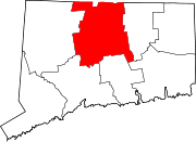
Canton is a rural town, incorporated in 1806, in Hartford County, Connecticut, United States. The population was 8,840 at the 2000 census. It is bordered by Granby on the north, Simsbury on the east, Avon and Burlington on the south, New Hartford on the west, and Barkhamsted on the northwest. Running through it is the Farmington River. The town includes the villages of North Canton, Canton Center, Canton, and Collinsville.
History
At the Collins ax factory in Collinsville, Elisha Root invented the important industrial technique of die casting.
Geography
According to the United States Census Bureau, the town has a total area of 25.0 square miles (64.9 km²), of which, 24.6 square miles (63.6 km²) of it is land and 0.5 square miles (1.2 km²) of it (1.88%) is water.
Demographics
As of the censusTemplate:GR of 2000, there were 8,840 people, 3,516 households, and 2,492 families residing in the town. The population density was 359.7 people per square mile (138.9/km²). There were 3,616 housing units at an average density of 147.2/sq mi (56.8/km²). The racial makeup of the town was 97.15% White, 0.53% African American, 0.05% Native American, 0.72% Asian, 0.02% Pacific Islander, 0.49% from other races, and 1.04% from two or more races. Hispanic or Latino of any race were 1.28% of the population.
There were 3,516 households out of which 33.4% had children under the age of 18 living with them, 60.2% were married couples living together, 8.1% had a female householder with no husband present, and 29.1% were non-families. 24.3% of all households were made up of individuals and 8.0% had someone living alone who was 65 years of age or older. The average household size was 2.49 and the average family size was 2.98.
In the town the population was spread out with 25.4% under the age of 18, 4.2% from 18 to 24, 30.8% from 25 to 44, 27.7% from 45 to 64, and 11.9% who were 65 years of age or older. The median age was 40 years. For every 100 females there were 94.0 males. For every 100 females age 18 and over, there were 90.9 males.
The median income for a household in the town was $65,013, and the median income for a family was $80,533. Males had a median income of $49,980 versus $37,652 for females. The per capita income for the town was $33,151. About 1.9% of families and 2.7% of the population were below the poverty line, including 3.2% of those under age 18 and 0.5% of those age 65 or over.
Canton is also home to Roaring Brook Nature Center.
| Voter Registration and Party Enrollment as of October 25, 2005 | |||||||||||||||||||||||||
|---|---|---|---|---|---|---|---|---|---|---|---|---|---|---|---|---|---|---|---|---|---|---|---|---|---|
| Party | Active Voters | Inactive Voters | Total Voters | Percentage | Republican | 1,859 | 2 | 1,861 | 29.08% | Democratic | 1,797 | 1 | 1,798 | 28.09% | Unaffiliated | 2,714 | 2 | 2,716 | 42.44% | Minor Parties | 25 | 0 | 25 | 0.39% | |
| Total | 6,395 | 5 | 6,400 | 100% | |||||||||||||||||||||
Transportation
The town is served by U.S. Routes 44 and 202 as well as Connecticut Routes 177, 179, and 309. Commuter bus service to Hartford is provided by Connecticut Transit Hartford; a Park & Ride lot is on Old River Road in Collinsville. Intercity train and bus services are provided from Union Station in Hartford, and the nearest large airport is Bradley International Airport, about 13 miles away in Windsor Locks.
References
- "Registration and Party Enrollment Statistics as of October 25, 2005" (PDF). Connecticut Secretary of State. Retrieved 2006-10-02.
- Canton Visitors Guide webpage at Town of Canton website, retrieved November 12, 2008
External links
- Town of Canton
- Canton Connecticut's Community Website
- Central Regional Tourism District
- Canton Public Schools history Web page
| Municipalities and communities of Hartford County, Connecticut, United States | ||
|---|---|---|
| County seat: Hartford | ||
| Cities |  | |
| Towns | ||
| CDPs | ||
| Other communities | ||