This is an old revision of this page, as edited by BG19bot (talk | contribs) at 05:47, 22 March 2016 (→See also: Remove blank line(s) between list items per WP:LISTGAP to fix an accessibility issue for users of screen readers. Do WP:GENFIXES and cleanup if needed. Discuss this at Misplaced Pages talk:WikiProject Accessibility#LISTGAP). The present address (URL) is a permanent link to this revision, which may differ significantly from the current revision.
Revision as of 05:47, 22 March 2016 by BG19bot (talk | contribs) (→See also: Remove blank line(s) between list items per WP:LISTGAP to fix an accessibility issue for users of screen readers. Do WP:GENFIXES and cleanup if needed. Discuss this at Misplaced Pages talk:WikiProject Accessibility#LISTGAP)(diff) ← Previous revision | Latest revision (diff) | Newer revision → (diff)| Shepperton Lock | |
|---|---|
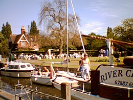
 Shepperton lock (2005) Shepperton lock (2005) | |
| 51°22′55.5″N 00°27′31″W / 51.382083°N 0.45861°W / 51.382083; -0.45861 | |
| Waterway | River Thames |
| County | Surrey |
| Maintained by | Environment Agency |
| Operation | Hydraulic |
| First built | 1813 |
| Latest built | 1899 |
| Length | 53.16 m (174 ft 5 in) |
| Width | 6.04 m (19 ft 10 in) |
| Fall | 2.03 m (6 ft 8 in) |
| Above sea level | 33' |
| Distance to Teddington Lock | 10 miles |
| Power is available out of hours | |
| Shepperton Lock | |||||||||||||||||||||||||||||||||||||||||||||||||||||||||||||||||||||||||||||||||||||||||||||||||||||||||||||||||||||||||||||||||||||
|---|---|---|---|---|---|---|---|---|---|---|---|---|---|---|---|---|---|---|---|---|---|---|---|---|---|---|---|---|---|---|---|---|---|---|---|---|---|---|---|---|---|---|---|---|---|---|---|---|---|---|---|---|---|---|---|---|---|---|---|---|---|---|---|---|---|---|---|---|---|---|---|---|---|---|---|---|---|---|---|---|---|---|---|---|---|---|---|---|---|---|---|---|---|---|---|---|---|---|---|---|---|---|---|---|---|---|---|---|---|---|---|---|---|---|---|---|---|---|---|---|---|---|---|---|---|---|---|---|---|---|---|---|---|
| Legend | |||||||||||||||||||||||||||||||||||||||||||||||||||||||||||||||||||||||||||||||||||||||||||||||||||||||||||||||||||||||||||||||||||||
| |||||||||||||||||||||||||||||||||||||||||||||||||||||||||||||||||||||||||||||||||||||||||||||||||||||||||||||||||||||||||||||||||||||
Shepperton Lock is a lock on the River Thames, in England adjoining the northern bank near Shepperton, Surrey (formerly Middlesex). It is across the river from Weybridge, but not directly accessible from there.
In 1813, the City of London Corporation built the pound lock on a cut along an existing watercourse to create Lock Island.
There are two weirs, one between Lock Island and Hamhaugh Island and the other larger one between Hamhaugh Island and the southern bank.
The Shepperton to Weybridge Ferry service runs from Ferry Lane below the lock to the end of Thames Street, Weybridge, where there are two rowing clubs and a canoeing club. Overlooking the lock and the islands is the Thames Court pub/restaurant.
History
A weir is recorded at Shepperton in the 1086 Domesday Book but this is unlikely to have been on the tidal Thames itself. There is also reference to a sluice or dam at Shepperton in 1293 and tolls being raised on passing ships, but the geography of the area is likely to have changed and these do not appear to refer to the site of the current lock. The lock was built in 1813 on the site of a small watercourse known as Stoner's Gut which ran across the neck of a hook in the river as it went to Weybridge. This channel was considered a nuisance to navigation and was not considered for use as the main channel as barges usually went to Weybridge or the Wey Navigation. Various accounts at the end of the 18th century record flood waters cutting through the gut and it is believed that there was a little wooden church built on piles over the river which was washed away. The gut was dammed and in 1805 came the first suggestion for a lock. After strong opposition, the proposal was put forward again in 1809 and a wooden lock was subsequently built. A stone lock was built in 1899, next to the existing wooden one which was then filled in and removed.
A small island adjoining the Surrey bank, upstream of the lock, may have been called Dog Ait at some point. This became corrupted into the name "Dockett" as in Dockett Eddy Lane. However, Dog Ait is shown on 19th century Ordnance Survey maps (1883, 1896) as being the previous name for the current Pharaoh's Island (see also below)
Access to the lock
The lock is on the Middlesex bank, and can be reached from Shepperton down Ferry Lane or from the Chertsey direction via Dockett Eddy Lane leading to Towpath. There is usually ample parking space. From the Weybridge side it can only be reached by the ferry.
Reach above the lock

Immediately above the lock is Pharaoh's Island, said to have been a gift from the nation to Admiral Nelson following the Battle of the Nile. In fact it did not gain this name until the early 20th century. The Middlesex bank is quite open with several larger houses along it until Dumsey Meadow a Site of Special Scientific Interest. The Surrey side is built up until parkland at Chertsey Meads, and then built up again at the edge of Chertsey itself. Chertsey Bridge crosses the river just before Chertsey Lock. On the backwater going past Chertsey Lock, which becomes the Abbey River, is the site of the Anglo-Saxon Chertsey Abbey sacked by the Vikings. Chertsey Regatta is held alongside Dumsey Meadow in August.
Thames Path
The Thames Path follows the northern (Middlesex) bank all the way to Chertsey Lock.
Literature and the Media
The lock in Charles Dickens Our Mutual Friend at Plashwater Mill is based on Shepperton lock.
In H. G. Wells The War of the Worlds one of the main battles fought against the invaders from Mars takes place between Weybridge and Shepperton lock.
See also
- Locks on the River Thames
- Rowing on the River Thames
- "Shepperton Lock". The River Thames Guide. Retrieved 2009-01-08.
| Next lock upstream | River Thames | Next lock downstream |
| Chertsey Lock 3.32 km (2.06 mi) |
Shepperton Lock Grid reference: TQ0725465964 |
Sunbury Lock 4.75 km (2.95 mi) |
References
- ^ "Environment Agency Dimensions of locks on the River Thames". web page. Environmental Agency. 8 November 2012. Retrieved 18 November 2012. Dimensions given in metres
- Thacker, Fred S (1968) . The Thames Highway: Volume II Locks and Weirs (New impression, 1st. ed.). Newton Abbot: David & Charles. ISBN 978-0-7153-4233-6. OCLC 55209571.
- ^ "Environment Agency Distances between locks on the River Thames". web page. Environmental Agency. 19 November 2012. Retrieved 22 November 2012. Distances given in km.
| Borough of Elmbridge | ||||||||||||||||||
|---|---|---|---|---|---|---|---|---|---|---|---|---|---|---|---|---|---|---|
| Towns, villages and neighbourhoods |
|  | ||||||||||||||||
| Notable parks | ||||||||||||||||||
| Places of worship | ||||||||||||||||||
| Education | ||||||||||||||||||
| Transport |
| |||||||||||||||||
| Buildings and structures |
| |||||||||||||||||
| Sport | ||||||||||||||||||
| Places listed are articles notable as settlements, arranged by post town The M25 motorway follows approximately a boundary and is included for its regional importance. | ||||||||||||||||||