This is an old revision of this page, as edited by Zackmann08 (talk | contribs) at 23:33, 1 November 2018 (Converting to use Template:Infobox settlement). The present address (URL) is a permanent link to this revision, which may differ significantly from the current revision.
Revision as of 23:33, 1 November 2018 by Zackmann08 (talk | contribs) (Converting to use Template:Infobox settlement)(diff) ← Previous revision | Latest revision (diff) | Newer revision → (diff) Municipality in Slovakia| Hrnčiarske Zalužany | |
|---|---|
| Municipality | |
 | |
  | |
| Coordinates: 48°24′N 19°52′E / 48.400°N 19.867°E / 48.400; 19.867 | |
| Country | Slovakia |
| Region | Banská Bystrica |
| District | Poltár |
| First mentioned | 1362 |
| Area | |
| • Total | 6.099 km (2.355 sq mi) |
| Elevation | 223 m (732 ft) |
| Population | |
| • Total | 874 |
| • Density | 140/km (370/sq mi) |
| Postal code | 980 12 |
| Area code | +421-47 |
| Car plate | PT |
| Website | www.hrnczaluzany.sk |
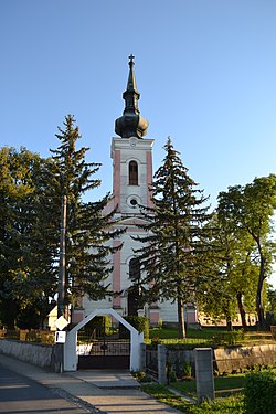
Hrnčiarske Zalužany is a village and municipality in the Poltár District in the Banská Bystrica Region of Slovakia. During history the inhabitants had been engaged in the production of pottery. At the end of 18th century in Hrnčiarske Zalužany existed the production of bricks and skids. Pottery production still exists, in the village is production cooperative and quite a few small private producers.
See also
References
Genealogical resources
The records for genealogical research are available at the state archive "Statny Archiv in Banska Bystrica, Slovakia"
- Roman Catholic church records (births/marriages/deaths): 1716-1900 (parish B)
External links
| Municipalities of Poltár District | ||
|---|---|---|
This Banská Bystrica Region geography article is a stub. You can help Misplaced Pages by expanding it. |