This is an old revision of this page, as edited by JJMC89 bot III (talk | contribs) at 19:19, 2 February 2021 (Moving Category:Lists of country subdivisions to Category:Lists of administrative divisions per Misplaced Pages:Categories for discussion/Speedy). The present address (URL) is a permanent link to this revision, which may differ significantly from the current revision.
Revision as of 19:19, 2 February 2021 by JJMC89 bot III (talk | contribs) (Moving Category:Lists of country subdivisions to Category:Lists of administrative divisions per Misplaced Pages:Categories for discussion/Speedy)(diff) ← Previous revision | Latest revision (diff) | Newer revision → (diff)| Departments of Bolivia Departamentos de Bolivia (Spanish) | |
|---|---|
 | |
| Category | Unitary State |
| Location | Plurinational State of Bolivia |
| Number | 9 |
| Populations | 110,436 (Pando) – 2,706,359 (La Paz) |
| Areas | 37,620 km (14,526 sq mi) (Tarija) – 370,620 km (143,098 sq mi) (Santa Cruz) |
| Government |
|
| Subdivisions | |
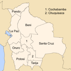
Bolivia is a unitary state consisting of nine departments (Template:Lang-es). Departments are the primary subdivisions of Bolivia, and possess certain rights under the Constitution of Bolivia. Each department is represented in the Plurinational Legislative Assembly—a bicameral legislature consisting of the Senate and the Chamber of Deputies. Each department is represented by four Senators, while Deputies are awarded to each department in proportion to their total population.
Out of the nine departments, La Paz was originally the most populous, with 2,706,351 inhabitants as of 2012 but the far eastern department of Santa Cruz has since surpassed it by 2020; Santa Cruz also claims the title as the largest, encompassing 370,621 square kilometres (143,098 sq mi). Pando is the least populated, with a population of 110,436. The smallest in area is Tarija, encompassing 37,623 square kilometres (14,526 sq mi).
Departments
| Flag | Department | ISO 3166-2 code | Capital city | Largest city | Population (2020) |
Area km (sq mi) |
Density per km (sq mi) |
Deputy seats |
|---|---|---|---|---|---|---|---|---|
| Beni | B | Trinidad | 480,308 | 213,564 (82,458) | 1.97 (5.10) | 9 | ||
| Chuquisaca | H | Sucre | 637,013 | 51,524 (19,894) | 11.18 (28.96) | 11 | ||
| Cochabamba | C | Cochabamba | 2,028,639 | 55,631 (21,479) | 31.6 (81.84) | 19 | ||
| La Paz | L | La Paz | El Alto | 2,926,996 | 133,985 (51,732) | 20.2 (52.32) | 29 | |
| Oruro | O | Oruro | 551,116 | 53,588 (20,690) | 9.22 (23.88) | 9 | ||
| Pando | N | Cobija | 154,355 | 63,827 (24,644) | 1.73 (4.48) | 5 | ||
| Potosí | P | Potosí | 901,555 | 118,218 (45,644) | 6.97 (18.05) | 14 | ||
| Santa Cruz | S | Santa Cruz de la Sierra | 3,370,059 | 370,621 (143,098) | 7.16 (18.54) | 25 | ||
| Tarija | T | Tarija | 583,330 | 37,623 (14,526) | 12.82 (33.20) | 9 | ||
See also
- ISO 3166-2:BO, the ISO codes for the departments of Bolivia.
- Bolivian autonomy referendums, 2008
- List of Bolivian departments by Human Development Index
References
- National Institute of Statistics of Bolivia (2012). "Bolivia Caracteristicas de Populacion y Vivienda: Censo Nacional de Populacion y Vivienda 2012" [Bolivia Characteristics of Population and Housing: National Censo of Population and Housing 2012] (PDF) (PDF) (in Spanish). Bolivian National Institute of Statistics. Archived from the original (PDF) on 9 February 2014. Retrieved 19 January 2014.
External links
| Departments of Bolivia | ||
|---|---|---|
| First-level administrative divisions of South American countries | |
|---|---|
| Table of administrative country subdivisions by country |