This is an old revision of this page, as edited by PrimeBOT (talk | contribs) at 20:29, 7 March 2022 (→top: Task 30: removal of deprecated infobx parameters). The present address (URL) is a permanent link to this revision, which may differ significantly from the current revision.
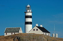
Revision as of 20:29, 7 March 2022 by PrimeBOT (talk | contribs) (→top: Task 30: removal of deprecated infobx parameters)(diff) ← Previous revision | Latest revision (diff) | Newer revision → (diff) Lighthouse View of the lighthouse View of the lighthouse | |
| Location | Halten, Trøndelag, Norway |
|---|---|
| Coordinates | 64°10′22″N 9°24′19″E / 64.1729°N 09.4054°E / 64.1729; 09.4054 |
| Tower | |
| Constructed | 1875 |
| Construction | Stone |
| Automated | 2005 |
| Height | 29.5 metres (97 ft) |
| Shape | Cylindrical |
| Markings | White with 2 black bands |
| Heritage | cultural property |
| Racon | T (—) |
| Light | |
| Focal height | 39 metres (128 ft) |
| Intensity | 1,080,000 candela |
| Range | 17.5 nmi (32.4 km; 20.1 mi) |
| Characteristic | Fl W 4s |
| Norway no. | 471800 |
Halten Lighthouse (Template:Lang-no) is a coastal lighthouse in the municipality of Frøya in Trøndelag county, Norway. The lighthouse is situated in the now uninhabited fishing village of Halten. It was first lit in 1875, and it is the northernmost of the chain of lighthouses marking the string of islands called Froan north of Frøya. The lighthouses include Sula Lighthouse in south, Vingleia Lighthouse, Finnvær Lighthouse, and finally Halten Lighthouse. The lighthouse emits the morse code letter "T" (—) as a racon signal.
The 29.5-metre (97 ft) tall stone lighthouse tower is painted white and it has two black horizontal stripes. The light sits at an elevation of 39 metres (128 ft). The light emits a white flash of light every four seconds. It has a luminous intensity of 1,080,000 candela and a visibility of up to 17.5 nautical miles (32.4 km; 20.1 mi).
The lighthouse tower was originally planned to build a twin-tower lighthouse with the Lista Lighthouse, but the technical development of lighthouses made this unnecessary so it was dismantled and rebuilt here. A lot of the original interior and exterior are preserved on the lighthouse and the station has been declared a historic preservation site. The station is still in use by the Norwegian Coastal Administration as a base station.
See also
References
- Wisting, Tor, ed. (2009-02-14). "Halten fyr". Store norske leksikon (in Norwegian). Kunnskapsforlaget. Retrieved 2018-02-22.
- ^ Rowlett, Russ (19 July 2011). "Lighthouses of Norway: Hitra and Frøya". The Lighthouse Directory. University of North Carolina at Chapel Hill. Retrieved 2018-02-22.
- Kystverket (2018). Norske Fyrliste (PDF) (in Norwegian). ISBN 9788245015959. Archived from the original (PDF) on 2018-06-12. Retrieved 2018-02-23.
External links
- Norsk Fyrhistorisk Forening (in Norwegian)
 Media related to Halten fyr at Wikimedia Commons
This Norwegian lighthouse-related article is a stub. You can help Misplaced Pages by expanding it. |