This is the current revision of this page, as edited by Gadfium (talk | contribs) at 01:56, 5 December 2024 (Update demographics). The present address (URL) is a permanent link to this version.
Revision as of 01:56, 5 December 2024 by Gadfium (talk | contribs) (Update demographics)(diff) ← Previous revision | Latest revision (diff) | Newer revision → (diff)
| This article needs additional citations for verification. Please help improve this article by adding citations to reliable sources. Unsourced material may be challenged and removed. Find sources: "Shelly Beach, New Zealand" – news · newspapers · books · scholar · JSTOR (November 2021) (Learn how and when to remove this message) |
| Shelly Beach Aotea | |
|---|---|
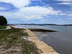
 Jetty at Shelly Beach Jetty at Shelly Beach | |
| Coordinates: 36°34′20″S 174°22′45″E / 36.57222°S 174.37917°E / -36.57222; 174.37917 | |
| Country | New Zealand |
| Region | Auckland Region |
| Ward | Rodney ward |
| Community board | Rodney Local Board |
| Subdivision | Kumeū subdivision |
| Electorates | |
| Government | |
| • Territorial Authority | Auckland Council |
| • Mayor of Auckland | Wayne Brown |
| • Kaipara ki Mahurangi MP | Chris Penk |
| • Te Tai Tokerau MP | Mariameno Kapa-Kingi |
| Area | |
| • Total | 0.31 km (0.12 sq mi) |
| Population | |
| • Total | 260 |
| • Density | 840/km (2,200/sq mi) |
Shelly Beach (Māori: Aotea), officially known as Aotea / Shelly Beach, is a settlement and beach located on the eastern side of Te Korowai-o-Te-Tonga Peninsula and the southwest side of Kaipara Harbour, North Auckland. In 2018, a seawall and five groynes were constructed to fight erosion.
History
The traditional Tāmaki Māori name for the area, Te Aukahanga o Aotea ("The Lashing of the Top Boards to the Hull of the Aotea"), recalls the visit of the Aotea migratory waka before the crew left for the south.
In 1884, a Ngāti Whātua parliament was held at Aotea / Shelly Beach, chaired by Paora Tūhaere.
Demographics
Statistics New Zealand describes Shelly Beach as a rural settlement, which covers 0.31 km (0.12 sq mi) and had an estimated population of 260 as of June 2024, with a population density of 839 people per km. Shelly Beach is part of the larger South Head statistical area.
| Year | Pop. | ±% p.a. |
|---|---|---|
| 2006 | 153 | — |
| 2013 | 231 | +6.06% |
| 2018 | 249 | +1.51% |
| 2023 | 273 | +1.86% |
| Source: | ||
Shelly Beach had a population of 273 in the 2023 New Zealand census, an increase of 24 people (9.6%) since the 2018 census, and an increase of 42 people (18.2%) since the 2013 census. There were 138 males and 138 females in 105 dwellings. 2.2% of people identified as LGBTIQ+. The median age was 48.7 years (compared with 38.1 years nationally). There were 51 people (18.7%) aged under 15 years, 24 (8.8%) aged 15 to 29, 144 (52.7%) aged 30 to 64, and 57 (20.9%) aged 65 or older.
People could identify as more than one ethnicity. The results were 89.0% European (Pākehā); 17.6% Māori; 6.6% Pasifika; 2.2% Asian; and 1.1% Middle Eastern, Latin American and African New Zealanders (MELAA). English was spoken by 100.0%, Māori language by 2.2%, Samoan by 1.1%, and other languages by 7.7%. New Zealand Sign Language was known by 1.1%. The percentage of people born overseas was 20.9, compared with 28.8% nationally.
Religious affiliations were 17.6% Christian, 1.1% Islam, 1.1% Māori religious beliefs, 1.1% Buddhist, and 1.1% New Age. People who answered that they had no religion were 67.0%, and 12.1% of people did not answer the census question.
Of those at least 15 years old, 18 (8.1%) people had a bachelor's or higher degree, 138 (62.2%) had a post-high school certificate or diploma, and 66 (29.7%) people exclusively held high school qualifications. The median income was $36,800, compared with $41,500 nationally. 30 people (13.5%) earned over $100,000 compared to 12.1% nationally. The employment status of those at least 15 was that 108 (48.6%) people were employed full-time, 30 (13.5%) were part-time, and 6 (2.7%) were unemployed.
References
- ^ "ArcGIS Web Application". statsnz.maps.arcgis.com. Retrieved 12 May 2022.
- ^ "Aotearoa Data Explorer". Statistics New Zealand. Retrieved 26 October 2024.
- Harriss, Gavin (March 2022). Shelly Beach, Auckland (Map). NZ Topo Map.
- "Council plans to build seawall and walkway at Shelly Beach". Stuff. 26 June 2018. Retrieved 18 November 2021.
- Sheffield, C. M. (2011). Men Came Voyaging (4th ed.). Auckland: Longley Printing Company Ltd. p. 23. ISBN 978-0-473-18059-1.
- ^ "Place name detail: Aotea / Shelly Beach". New Zealand Gazetteer. New Zealand Geographic Board. Retrieved 1 February 2024.
- 2018 Census place summary: South Head
- "Statistical area 1 dataset for 2018 Census". Statistics New Zealand. March 2020. 7001259 and 7001260.
- ^ "Totals by topic for individuals, (RC, TALB, UR, SA3, SA2, Ward, Health), 2013, 2018, and 2023 Censuses". Stats NZ – Tatauranga Aotearoa – Aotearoa Data Explorer. Shelly Beach (1070). Retrieved 3 October 2024.
- "Totals by topic for dwellings, (RC, TALB, UR, SA3, SA2, Ward, Health), 2013, 2018, and 2023 Censuses". Stats NZ – Tatauranga Aotearoa – Aotearoa Data Explorer. Retrieved 3 October 2024.
| Kumeū Subdivision – Rodney, Auckland, New Zealand | |
|---|---|
| Populated places | |
| Geographic features |
|
| Facilities and attractions | |
| Government | |
| Organisations | |
| Related articles | |