This is the current revision of this page, as edited by Babylon77 (talk | contribs) at 15:54, 20 December 2024 (typo). The present address (URL) is a permanent link to this version.
Revision as of 15:54, 20 December 2024 by Babylon77 (talk | contribs) (typo)(diff) ← Previous revision | Latest revision (diff) | Newer revision → (diff) River in France| La Vere | |
|---|---|
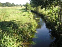
 La Vere flowing between Saint-Georges-des-Groseillers and La Lande-Patry La Vere flowing between Saint-Georges-des-Groseillers and La Lande-Patry | |
  | |
| Location | |
| Country | France |
| Physical characteristics | |
| Source | |
| • location | Landigou, Orne |
| Mouth | Noireau |
| • coordinates | 48°50′59.7″N 0°31′07.4″W / 48.849917°N 0.518722°W / 48.849917; -0.518722 |
| Length | 24.78 km (15.40 mi) |
| Basin features | |
| Progression | Noireau→ Orne→ English Channel |
La Vere is a river in northwestern France, flowing through the department of Orne. It is 24.78 km long. Its source is in Landigou, and it flows into the river Noireau in the commune of Saint-Pierre-du-Regard and through Suisse Normande. It flows through these other communes Athis-Val de Rouvre, Aubusson, Caligny, Flers, La Lande-Patry, Messei, Montilly-sur-Noireau, Saint-Georges-des-Groseillers, Sainte-Honorine-la-Chardonne & La Selle-la-Forge many of which are in the area known as Suisse Normande.

