This is an old revision of this page, as edited by Tobias Conradi (talk | contribs) at 15:12, 20 July 2007 (Department). The present address (URL) is a permanent link to this revision, which may differ significantly from the current revision.
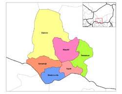
Revision as of 15:12, 20 July 2007 by Tobias Conradi (talk | contribs) (Department)(diff) ← Previous revision | Latest revision (diff) | Newer revision → (diff)The department of Maradi is located east of the department of Tahoua and west of Zinder, in the center of Niger, north of Nigeria's city of Kano. The administrative center is at Maradi. The population of the department is majority Hausa. Most of the 38,581 km² of land is classified as "Sahel," though the northern parts head toward desert, and the very southern edges along the boarder with Nigeria get almost enough rain to be considered tropical (?).
The Maradi (Niger)-Nigeria border dips south below the department's capital, forming an area sometimes called the "breadbasket" of Niger. Tobacco, peanuts, mangoes, wheat, soy beans and even cotton can be found grown in some, along with the national staples of millet, sorghum and cow peas.

Maradi is divided into 6 arrondissements:
Maradi has the following foreign borders:
- Katsina State, Nigeria - south
- Zamfara State, Nigeria - southwest
- Sokoto State, Nigeria - far southwest
Domestically, it borders the following departments:
See also:
External links
This Niger location article is a stub. You can help Misplaced Pages by expanding it. |