This is an old revision of this page, as edited by OlEnglish (talk | contribs) at 10:36, 28 June 2008 (minor copyedit). The present address (URL) is a permanent link to this revision, which may differ significantly from the current revision.
Revision as of 10:36, 28 June 2008 by OlEnglish (talk | contribs) (minor copyedit)(diff) ← Previous revision | Latest revision (diff) | Newer revision → (diff)
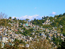
The Sivalik Hills also known as the Sivalik mountains (also spelled Shiwalik, Shivalik, or Siwalik) and sometimes called Churia or Chure Hills or Outer Himalaya are the southernmost and geologically youngest east-west mountain chain of the Himalayan System. The Sivalik Hills crest at 900 to 1,200 meters and have many sub-ranges. They extend 1,600 km from the Teesta River in Sikkim, westward through Nepal and Uttarakhand, continuing into Kashmir and Northern Pakistan. The Mohan Pass is the principal pass accessing the Sivalik Hills from Saharanpur in Uttar Pradesh to Dehra and the hill station of Mussoorie in Uttarakhand. Eastward they are cut through at wide intervals by large rivers flowing south from the Himalaya. Smaller rivers without sources in the high Himalaya are more likely to detour around sub-ranges.There are vast networks of small rills and channels to form streams which are ephemeral (transient) in nature.
The Sivalik Hills are chiefly composed of sandstone and conglomerate formations which are the solidified detritus of the great range in their rear, but often poorly consolidated. They are bounded on the south by a fault system called the Main Frontal Thrust, with steeper slopes on that side. Sivapithecus (a kind of ape, formerly known as Ramapithecus) is among many fossil finds in the Sivalik region.
The alluvial Bhabhar zone makes the transition from the steep southern slopes of the Sivaliks to the nearly level plains. Rainfall, especially during the summer monsoon, percolates downslope and emerges in a zone of springs and marshes along the northern edge of the Terai or plains. This wet zone was heavily malarial before DDT was used to suppress mosquitoes. It was left forested by official decree by Nepal's Rana rulers as a defensive perimeter called Char Kose Jhadi (four kos forest, a kos equalling about two miles).
North of the Sivalik belt lies a higher range, the 1,500-3,000 meter Mahabharat Lekh (Range) also known as the Lesser Himalaya. In many places the two ranges are adjacent, in others valleys 10-20 km wide separate them. These valleys are called Duns or Doons in India (as in, for example, the Doon Valley) which includes Dehradun, as also Patli Dun and Kothri Dun, both in Corbett National Park in Uttarakhand, and also Pinjore Dun in Himachal Pradesh. In Nepal, they are called Inner Terai and include Chitwan, Dang-Deukhuri and Surkhet.
The permeable sediments and poorly-developed soils of the Sivalik hills do not retain water between storms and are unsuited to agriculture. They are lightly populated by a few tribal groups, especially the Van Gujjars, or Gujjars, that follow a quasi-pastoral livestock-dependent lifestyle and are responsible for heavy deforestation and denudation in many parts, given that the size of their herds has dramatically outgrown the ecosystems' capacity to sustain them.
Low population densities throughout the Sivaliks and along the steep southern slopes of the Mahabharat Range, plus virulent malaria in the damp forests of the Sivaliks' alluvial skirts amounted to a cultural, linguistic and political buffer zone between the north Indian plains and the densely populated "hills" beyond the Mahabharat escarpment, allowing the two zones to evolve differently.
References
 This article incorporates text from a publication now in the public domain: Chisholm, Hugh, ed. (1911). Encyclopædia Britannica (11th ed.). Cambridge University Press.
 {{cite encyclopedia}}: Missing or empty|title=(help)
| Geography of South Asia | |||||||||
|---|---|---|---|---|---|---|---|---|---|
| Mountains |
| ||||||||
| Plateaus |
| ||||||||
| Deserts | |||||||||
| Lowlands |
| ||||||||
| Water-bodies |
| ||||||||
| Islands | |||||||||
| By country | |||||||||
| By region | |||||||||