This is an old revision of this page, as edited by Nichalp (talk | contribs) at 12:19, 25 August 2008 (Reverted edits by 220.227.160.70 (talk) to last version by Ganeshk). The present address (URL) is a permanent link to this revision, which may differ significantly from the current revision.
Revision as of 12:19, 25 August 2008 by Nichalp (talk | contribs) (Reverted edits by 220.227.160.70 (talk) to last version by Ganeshk)(diff) ← Previous revision | Latest revision (diff) | Newer revision → (diff) Size of this PNG preview of this SVG file: 514 × 600 pixels. Other resolutions: 206 × 240 pixels | 411 × 480 pixels | 658 × 768 pixels | 877 × 1,024 pixels | 1,755 × 2,048 pixels | 1,486 × 1,734 pixels.
Original file (SVG file, nominally 1,486 × 1,734 pixels, file size: 252 KB)
| This is a file from the Wikimedia Commons. Information from its description page there is shown below. Commons is a freely licensed media file repository. You can help. |
| This is a featured picture, which means that members of the community have identified it as one of the finest images on the English Misplaced Pages, adding significantly to its accompanying article. If you have a different image of similar quality, be sure to upload it using the proper free license tag, add it to a relevant article, and nominate it. |
| This image was selected as picture of the day on the English Misplaced Pages for August 15, 2006. |
|
| Please note: This image is used in at least one case as a base map for a locator image; if you change or replace it in a way that moves its geographic features, images superimposed on it at specific locations will no longer be accurate. Please be careful. Thank you. |
Contents
Summary
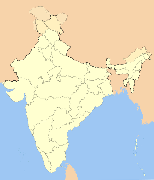
Blank locator map of India
SVG Map drawn by me, Nichalp using Inkscape.
Boundaries as per known in 2006.
Legend
| Color | Hex | Transp | Sample | Key |
|---|---|---|---|---|
| Light green | #ffffd0 | 100% | Territory administered by India (undisputed) | |
| Yellowish-orange | #fff0bf | 20% | Disputed area 1: Administered by India. Claimed by China/Pakistan | |
| Orangish-Yellow | #fbe3bb | 50% | Disputed area 2: Administered by China/Pakistan. Claimed by India | |
| Orange | #f7d3aa | 50% | Neighbouring countries |

Sources
- Indian Railways archive copy at the Wayback Machine
- http://www.lib.utexas.edu/maps/china.html : (China-India Border: Eastern Sector 1988 (452K) & China-India Border: Western Sector 1988 (319K)
- http://www.lib.utexas.edu/maps/india.html : India (Political) 2001 (257K) and pdf format (276K)
Licensing
I, the copyright holder of this work, hereby publish it under the following licenses:
|
Permission is granted to copy, distribute and/or modify this document under the terms of the GNU Free Documentation License, Version 1.2 or any later version published by the Free Software Foundation; with no Invariant Sections, no Front-Cover Texts, and no Back-Cover Texts. A copy of the license is included in the section entitled GNU Free Documentation License.http://www.gnu.org/copyleft/fdl.htmlGFDLGNU Free Documentation Licensetruetrue |
- You are free:
- to share – to copy, distribute and transmit the work
- to remix – to adapt the work
- Under the following conditions:
- attribution – You must give appropriate credit, provide a link to the license, and indicate if changes were made. You may do so in any reasonable manner, but not in any way that suggests the licensor endorses you or your use.
- share alike – If you remix, transform, or build upon the material, you must distribute your contributions under the same or compatible license as the original.
Captions
Mapa podziału administracyjnego Republiki Indiiಭಾರತದ ನಕ್ಷೆभारत के पूरे राज्य और भारत के नक्शे में कैसे दिखता हैCarte de l'IndeКарта Индииഇന്ത്യ ഭൂപടംभारतस्य मानचित्रम्இந்திய வரைபடம்Karte der Republik Indien.ہندستان کے پورے صوبے نقشے میں کیسے دکھتے ہیں۔Items portrayed in this file
depicts
India
map
copyright status<\/a>"}},"text\/plain":{"en":{"":"copyright status"}}},"{\"value\":{\"entity-type\":\"item\",\"numeric-id\":50423863,\"id\":\"Q50423863\"},\"type\":\"wikibase-entityid\"}":{"text\/html":{"en":{"P6216":"copyrighted<\/a>"}},"text\/plain":{"en":{"P6216":"copyrighted"}}}}">copyright status
copyrighted
copyright license<\/a>"}},"text\/plain":{"en":{"":"copyright license"}}},"{\"value\":{\"entity-type\":\"item\",\"numeric-id\":19113751,\"id\":\"Q19113751\"},\"type\":\"wikibase-entityid\"}":{"text\/html":{"en":{"P275":"Creative Commons Attribution-ShareAlike 2.5 Generic<\/a>"}},"text\/plain":{"en":{"P275":"Creative Commons Attribution-ShareAlike 2.5 Generic"}}},"{\"value\":{\"entity-type\":\"item\",\"numeric-id\":14946043,\"id\":\"Q14946043\"},\"type\":\"wikibase-entityid\"}":{"text\/html":{"en":{"P275":"Creative Commons Attribution-ShareAlike 3.0 Unported<\/a>"}},"text\/plain":{"en":{"P275":"Creative Commons Attribution-ShareAlike 3.0 Unported"}}},"{\"value\":{\"entity-type\":\"item\",\"numeric-id\":19068220,\"id\":\"Q19068220\"},\"type\":\"wikibase-entityid\"}":{"text\/html":{"en":{"P275":"Creative Commons Attribution-ShareAlike 2.0 Generic<\/a>"}},"text\/plain":{"en":{"P275":"Creative Commons Attribution-ShareAlike 2.0 Generic"}}},"{\"value\":{\"entity-type\":\"item\",\"numeric-id\":47001652,\"id\":\"Q47001652\"},\"type\":\"wikibase-entityid\"}":{"text\/html":{"en":{"P275":"Creative Commons Attribution-ShareAlike 1.0 Generic<\/a>"}},"text\/plain":{"en":{"P275":"Creative Commons Attribution-ShareAlike 1.0 Generic"}}},"{\"value\":{\"entity-type\":\"item\",\"numeric-id\":50829104,\"id\":\"Q50829104\"},\"type\":\"wikibase-entityid\"}":{"text\/html":{"en":{"P275":"GNU Free Documentation License, version 1.2 or later<\/a>"}},"text\/plain":{"en":{"P275":"GNU Free Documentation License, version 1.2 or later"}}}}">copyright license
Creative Commons Attribution-ShareAlike 2.5 Generic
Creative Commons Attribution-ShareAlike 3.0 Unported
Creative Commons Attribution-ShareAlike 2.0 Generic
Creative Commons Attribution-ShareAlike 1.0 Generic
GNU Free Documentation License, version 1.2 or later
media type<\/a>"}},"text\/plain":{"en":{"":"media type"}}},"{\"value\":\"image\\\/svg+xml\",\"type\":\"string\"}":{"text\/html":{"en":{"P1163":"image\/svg+xml"}},"text\/plain":{"en":{"P1163":"image\/svg+xml"}}}}">media type
image/svg+xml
data size<\/a>"}},"text\/plain":{"en":{"":"data size"}}},"{\"value\":{\"amount\":\"+257989\",\"unit\":\"http:\\\/\\\/www.wikidata.org\\\/entity\\\/Q8799\"},\"type\":\"quantity\"}":{"text\/html":{"en":{"P3575":"257,989 byte<\/span>"}},"text\/plain":{"en":{"P3575":"257,989 byte"}}}}">data size
257,989 byte
checksum<\/a>"}},"text\/plain":{"en":{"":"checksum"}}},"{\"value\":\"5948e7c27cd6a4b9ae8ae1467dc8dfbe99b31e46\",\"type\":\"string\"}":{"text\/html":{"en":{"P4092":"5948e7c27cd6a4b9ae8ae1467dc8dfbe99b31e46"}},"text\/plain":{"en":{"P4092":"5948e7c27cd6a4b9ae8ae1467dc8dfbe99b31e46"}}},"{\"value\":{\"entity-type\":\"property\",\"numeric-id\":459,\"id\":\"P459\"},\"type\":\"wikibase-entityid\"}":{"text\/html":{"en":{"":"determination method or standard<\/a>"}},"text\/plain":{"en":{"":"determination method or standard"}}},"{\"value\":{\"entity-type\":\"item\",\"numeric-id\":13414952,\"id\":\"Q13414952\"},\"type\":\"wikibase-entityid\"}":{"text\/html":{"en":{"P459":"SHA-1<\/a>"}},"text\/plain":{"en":{"P459":"SHA-1"}}}}">checksum
5948e7c27cd6a4b9ae8ae1467dc8dfbe99b31e46
determination method or standard: SHA-1File history
Click on a date/time to view the file as it appeared at that time.
| Date/Time | Thumbnail | Dimensions | User | Comment | |
|---|---|---|---|---|---|
| current | 14:01, 14 October 2020 |  | 1,486 × 1,734 (252 KB) | NordNordWest | upd Telangana/Andhra Pradesh |
| 17:48, 25 July 2020 |  | 1,486 × 1,734 (252 KB) | NordNordWest | Jammu and Kashmir/Ladakh | |
| 01:42, 1 April 2017 |  | 1,486 × 1,734 (337 KB) | Utcursch | Moved Telangana to states layer | |
| 14:08, 29 January 2016 |  | 1,486 × 1,734 (379 KB) | Csyogi | Telangana update | |
| 15:36, 16 May 2006 |  | 1,486 × 1,734 (421 KB) | Nichalp | Siachen edits | |
| 12:49, 13 May 2006 |  | 1,486 × 1,734 (424 KB) | Nichalp | Siachen correction | |
| 12:43, 13 May 2006 |  | 1,486 × 1,734 (422 KB) | Nichalp | border changes | |
| 05:53, 9 May 2006 |  | 1,486 × 1,734 (421 KB) | Nichalp | Updates as suggested in FPC | |
| 07:48, 7 May 2006 |  | 1,486 × 1,734 (421 KB) | Nichalp | Version 2; added some additional disputed areas in the Western sector | |
| 18:27, 6 May 2006 |  | 1,486 × 1,734 (416 KB) | Nichalp | Blank locator map of India SVG Map drawn by me, ~~~~ category:Maps of India |
File usage
More than 100 pages use this file. The following list shows the first 100 pages that use this file only. A full list is available.
- Geography of Kochi
- Kallayi River
- Parliament
- States and union territories of India
- Talk:2001 Bangladesh–India border clashes
- Talk:Athirampuzha
- Talk:Attukal
- Talk:Azadirachta indica
- Talk:Babulnath Temple
- Talk:Battle of Khanwa
- Talk:Belagavi border dispute
- Talk:Believers Eastern Church
- Talk:Berar Province
- Talk:Bnei Menashe
- Talk:Bombay Natural History Society
- Talk:Brahmapur, Kolkata
- Talk:Brahmaputra Mail train bombing
- Talk:Chambal Garden
- Talk:Chennai Port
- Talk:Coronation Bridge
- Talk:Daman Ganga River
- Talk:Eastern Coastal Plains
- Talk:English and Foreign Languages University
- Talk:Fatuha train crash
- Talk:First Anglo-Maratha War
- Talk:Gambhir River (Rajasthan)
- Talk:Ghaggar-Hakra River
- Talk:Golden Temple Mail
- Talk:Hammiradeva
- Talk:Jaswant Singh of Bharatpur
- Talk:Jaswant Thada
- Talk:Junior commissioned officer
- Talk:Kamarajar Port
- Talk:Khatkar
- Talk:Kishan Singh of Bharatpur
- Talk:Kolkata Race Course
- Talk:Kudankulam
- Talk:Lady Jamshetjee Road
- Talk:Leaf muntjac
- Talk:Maliguda Tunnel
- Talk:Na people
- Talk:Najma Heptulla
- Talk:Neighbourhoods in Kolkata Metropolitan Area
- Talk:Noyyal River
- Talk:Outer Ring Road, Bengaluru
- Talk:Outer Ring Road, Delhi
- Talk:Palace on Wheels
- Talk:Panikoili
- Talk:Parama China kingdom
- Talk:Porahat
- Talk:Rajdhanwar
- Talk:Ranjit Singh of Bharatpur
- Talk:Ratan Singh of Bharatpur
- Talk:Sabarmati Express
- Talk:Salsette–Trombay Railway
- Talk:Sarai Banjara train disaster
- Talk:Sardar Sarovar Dam
- Talk:Sawai Jai Singh
- Talk:Second Anglo-Maratha War
- Talk:Sholavaram
- Talk:Southern Railway zone
- Talk:State Highway 87 (Karnataka)
- Talk:Third Anglo-Maratha War
- Talk:Vadodara train crash
- Talk:Varapoha Falls
- User:Ganeshk/In the news July 11 2006
- User:Spundun/SandBox
- User talk:Nichalp/Archive34
- Misplaced Pages:Featured picture candidates/India-locator-map-blank
- Misplaced Pages:Featured picture candidates/India-locator-map-blank.svg
- Misplaced Pages:Featured picture candidates/May-2006
- Misplaced Pages:Featured picture candidates/delist/2006
- Misplaced Pages:POTD/August 15, 2006
- Misplaced Pages:POTD column/August 15, 2006
- Misplaced Pages:POTD row/August 15, 2006
- Misplaced Pages:Picture of the day/August 15, 2006
- Misplaced Pages:Picture of the day/August 2006
- Misplaced Pages:Today's featured article/February 18, 2006
- Misplaced Pages:Today's featured article/February 2006
- Misplaced Pages:WikiProject Maps
- Misplaced Pages:Misplaced Pages Signpost/2006-05-22/Features and admins
- Misplaced Pages talk:In the news/Archive 8
- Misplaced Pages talk:Noticeboard for India-related topics/Archive 10
- File talk:India-locator-map-blank.svg
- File talk:India roadway map.svg
- Template:India States and Territories Labelled Map
- Template:WikiProject India
- Category:Misplaced Pages requested maps in India
- Portal:India/Picture of the week, 2006
- Portal:India/Picture of the week 43, 2006
- Portal:India/SC Summary/SA Political integration of India
- Portal:India/SC Summary/SP Blank locator map
- Portal:India/Selected picture candidates/Archived nominations
- Portal:India/Selected picture candidates/India locator map
- Portal:India/Today's selected article/December 12, 2006
- Portal:India/Today's selected article/December 2006
- Portal:India/Today's selected article/March 2006
- Portal:India/Today's selected article/March 31, 2006
- Portal:India/Today's selected article/May 2006
- Portal:India/Today's selected article/May 4, 2006
View more links to this file.
Global file usage
The following other wikis use this file:
- Usage on as.wikipedia.org
- Usage on as.wikiquote.org
- Usage on awa.wikipedia.org
- खाँचा:ज्ञानसन्दूक भारत कय क्षेत्र
- भारत कय राज्य
- भारत कय संघ राज्यक्षेत्र
- खाँचा:India States and Territories Labelled Map
- खाँचा:Infobox Indian Jurisdiction
- खाँचा:Infobox Indian Jurisdiction/Examples/city
- खाँचा:Infobox Indian Jurisdiction/Examples/district
- खाँचा:Infobox Indian Jurisdiction/Examples/neighbourhood
- खाँचा:Infobox Indian Jurisdiction/Examples/protected area
- खाँचा:Infobox Indian Jurisdiction/Examples/state
- खाँचा:Infobox Indian Jurisdiction/Examples/suburb
- खाँचा:Infobox Indian Jurisdiction/Examples/town
- खाँचा:Infobox Indian Jurisdiction/Examples/village
- खाँचा:Infobox Indian Jurisdiction/Sandbox
- खाँचा:Infobox Indian Jurisdiction/Sandbox/doc
- खाँचा:Infobox Indian Jurisdiction/doc
- खाँचा:ज्ञानसन्दूक भारत कय क्षेत्र/doc
- सीधी
- Usage on ban.wikipedia.org
- Usage on bn.wikipedia.org
- Usage on bpy.wikipedia.org
View more global usage of this file.
Metadata
This file contains additional information, probably added from the digital camera or scanner used to create or digitize it.
If the file has been modified from its original state, some details may not fully reflect the modified file.
| Width | 1486px |
|---|---|
| Height | 1734px |