This is an old revision of this page, as edited by Warofdreams (talk | contribs) at 22:01, 2 March 2004 ({{msg:Ireland_counties}}). The present address (URL) is a permanent link to this revision, which may differ significantly from the current revision.
Revision as of 22:01, 2 March 2004 by Warofdreams (talk | contribs) ({{msg:Ireland_counties}})(diff) ← Previous revision | Latest revision (diff) | Newer revision → (diff)
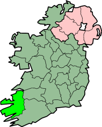
County Kerry (Ciarraí in Irish) is a county in the southwest of the island of Ireland, in the Munster province of the Republic of Ireland. It has an area of 4701 km² (1815 square miles) and a population (census 2002) of 132,424. The county town is Tralee. The county is bordered by County Limerick (east) and County Cork (South-east).
One of Ireland's most famous towns, Killarney, is located in Kerry. The county has two national parks, the Killarney Lakes and Dingle Peninsula. The tip of the Dingle Peninsula is the most westerly point in mainland Ireland.
Kerry has the highest mountains in Ireland: Macgillicuddy's Reeks.
Kerry is bordered on the west by the Atlantic Ocean and on the north by the River Shannon, the longest river in Ireland.
Kerry's coast is a series of peninsulas and large bays. As well as the Dingle Peninsula there is the Ring of Kerry, a popular location for cyclists.
Just off Kerry's coast are a number of islands, including the Blasket Islands and the Skelligs. Skellig Michael is a World Heritage Site, famous for the medieval monastery clinging to the island's cliffs.
Cities and Towns
- Castleisland (Oileán Ciarraí)
- Dingle
- Kenmare (An Neidín)
- Killarney (Cill Airne)
- Killorglin (Cill Orglan)
- Listowel (Lios Tuathail)
- Tralee (Trá Lí)
Historical Sites
See also: Republic of Ireland
| Counties of Ireland | ||
|---|---|---|
| The counties are listed per province | ||
 | ||
| ||