This is an old revision of this page, as edited by Mooo (talk | contribs) at 04:33, 9 January 2006. The present address (URL) is a permanent link to this revision, which may differ significantly from the current revision.
Revision as of 04:33, 9 January 2006 by Mooo (talk | contribs)(diff) ← Previous revision | Latest revision (diff) | Newer revision → (diff)
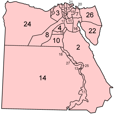
Egypt is divided into 26 governorates (muhafazat, singular - muhafazah)& One city of special manner(Al Uqsur (Luxor), sorted by the transliterated Arabic name:
- Ad Daqahliyah (Dakahleya) الدقهلية
- Al Bahr al Ahmar (Red Sea) البحر الأحمر
- Al Buhayrah (Beheira) البحيرة
- Al Fayyum (Fayum) الفيوم
- Al Gharbiyah (Gharbeya) الغربية
- Al Iskandariyah (Alexandria) الإسكندرية
- Al Isma'iliyah (Ismailia) الإسماعيلية
- Al Jizah (Giza) الجيزة
- Al Minufiyah (Menufeya) المنوفية
- Al Minya (Minya) المنيا
- Al Qahirah (Cairo) القاهرة
- Al Qalyubiyah (Kalyubeya) القليوبية
- Al Wadi al Jadid (New Valley) الوادي الجديد
- Ash Sharqiyah (Sharkeya) الشرقية
- As Suways (Suez) السويس
- Aswan أسوان
- Asyut أسيوط
- Bani Suwayf (Beni Suef) بني سويف
- Bur Sa'id (Port Saïd) پورسعيد
- Dimyat (Damietta) دمياط
- Janub Sina' (South Sinai) جنوب سيناء
- Kafr ash Shaykh (Kafr el Sheikh) كفر الشيخ
- Matruh مطروح
- Qina قنا
- Shamal Sina' (North Sinai) شمال سيناء
- Suhaj (Sohag) سوهاج
- Al Uqsur (Luxor) الأقصر
Most governorates have a population density of more than 1000 per km², while the three large ones have a population density of less than 2 per km²