This is an old revision of this page, as edited by L'ecrivant (talk | contribs) at 08:23, 2 September 2010 (Undid revision 382436038 by 98.23.129.83 (talk) - dubious!). The present address (URL) is a permanent link to this revision, which may differ significantly from the current revision.
Revision as of 08:23, 2 September 2010 by L'ecrivant (talk | contribs) (Undid revision 382436038 by 98.23.129.83 (talk) - dubious!)(diff) ← Previous revision | Latest revision (diff) | Newer revision → (diff) Not to be confused with Ebla. This article is about the Tuscan island. For other uses, see Elba (disambiguation).| Geography | |
|---|---|
| Location | Tyrrhenian Sea |
| Coordinates | 42°45.71′N 10°14.45′E / 42.76183°N 10.24083°E / 42.76183; 10.24083 |
| Archipelago | Tuscan Archipelago |
| Area | 224 km (86 sq mi) |
| Coastline | 147 km (91.3 mi) |
| Highest elevation | 1,018 m (3340 ft) |
| Administration | |
| Italy | |
| Demographics | |
| Population | 31,572 |
| Pop. density | 140/km (360/sq mi) |
Elba (Template:Lang-it, Template:Lang-la) is a Mediterranean island in Tuscany, Italy, 20 kilometres (12 mi) from the coastal town of Piombino. The largest island of the Tuscan Archipelago, Elba is also part of the National Park of the Tuscan Archipelago and the third largest island in Italy after Sicily and Sardinia. It is located between the Tyrrhenian Sea and Ligurian Sea, about 50 kilometres (30 mi) east of the French island of Corsica.
The island is divided into eight municipalities, of which Portoferraio is the main one, the others; Campo nell'Elba, Capoliveri, Marciana, Marciana Marina, Porto Azzurro, Rio Marina, and Rio nell'Elba, are part of the province of Livorno, with a total of about 30,000 inhabitants, which increases considerably during the summer.
Geography
The island of Elba is the largest remaining stretch of land from the ancient tract that once connected the Italian peninsula to Corsica. The northern coast faces the Ligurian Sea; the eastern coast the Piombino Channel; the southern coast the Tyrrhenian Sea; while the Corsica channel divides the western tip of the Island from neighbouring Corsica.
The terrain is quite varied, and is thus divided into several areas based on geomorphology. The mountainous and most recent part of the island can be found to the west, the center of which is dominated by Mount Capanne (1,018 metres (3,340 ft)), also called the "roof of the Tuscan Archipelago". The mountain is home to many animal species including the mouflon and wild boar, two species that flourish despite the continuous influx of tourists. The central part of the island is a mostly flat section with the width being reduced to just four kilometres. It is where the major centres can be found: Portoferraio, Campo nell'Elba. To the east is the oldest part of the island, formed over 400 million years ago. In the hilly area, dominated by Monte Calamita, are the deposits of iron that made Elba famous.
Hydrography
Rivers rarely exceed 3 km in length on the island and it is common for those of lesser length to dry up over the summer period. The most important, sorted by length, are:
- Fosso San Francesco 6.5 km;
- Fosso Barion, 5.1 km;
- Fosso Redinoce, 2 km
Between Poggio and Marciana, at the foot of Mount Capanne, is a natural spring called Fonte Napoleone, which is regarded for its quality.
Climate
The climate of the Island is predominantly Mediterranean, except for Mount Capanne, where winters tend to be moderately cold. Precipitation is concentrated in autumn and comprises a normal rainfall.
The table below shows the average temperatures for the islands by month.
| Month | Jan | Feb | Mar | Apr | May | June | July | Aug | Sep | Oct | Nov | Dec | Year |
|---|---|---|---|---|---|---|---|---|---|---|---|---|---|
| Maximum Temperature (°C) | 12 | 13 | 14 | 16 | 21 | 24 | 27 | 27 | 25 | 20 | 15 | 13 | 18,9 |
| Minimum Temperature (°C) | 8 | 9 | 10 | 12 | 16 | 19 | 22 | 21 | 19 | 15 | 10 | 8 | 14,1 |
| Rain Fall (mm) | 61 | 53 | 51 | 47 | 28 | 24 | 13 | 30 | 51 | 82 | 86 | 69 | 595 |
History
Originally inhabited by Ligures Ilvati who gave the ancient name Ilva, the island was well known from very ancient times for its iron resources and its valued mines. The Greeks called it Aethalia (fume) after the fumes of the furnaces for the metal production.
The island was then invaded, first by the Etruscans and later (after 480 BC) by the Romans. After the Roman period, the island was ravaged by barbarians and Saracens. In the early 11th century it became a possession of the Republic of Pisa. When the latter was sold to the Visconti of Milan in 1398, the island was acquired by the Appiani, Lords of Piombino, who retained it for two centuries. In 1546 part of the island was handed over to Cosimo I de' Medici, who fortified Portoferraio and renamed it "Cosmopoli", while in 1577 the rest of the island was returned to the Appiani. In 1596 Philip II of Spain captured Porto Azzurro and has two fortresses built there. In 1802 the island became a French possession, and its economy flourished.

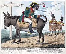
Following the Treaty of Fontainebleau, French emperor Napoleon I was exiled to Elba after his forced abdication in 1814 and arrived at Portoferraio on May 3, 1814 to begin his exile there. He was allowed to keep a personal guard of six hundred men. Although he was nominally sovereign of Elba, the island was patrolled by the British Navy.
During the months Napoleon stayed on the island, he carried out a series of economic and social reforms to improve the quality of life, partly to pass the time and partly out of a genuine concern for the well-being of the islanders. Napoleon stayed on Elba for 300 days. He returned to France on February 26, 1815 for the Hundred Days. After his defeat at Waterloo he was subsequently exiled again, this time to the barren and isolated South Atlantic island of Saint Helena. Napoleon's stay on Elba is the basis for the famous English language palindrome: "Able was I ere I saw Elba." Internationally, Elba is best known for its connection to Napoleon.
In the Congress of Vienna the island was given to the Grand Duchy of Tuscany. In 1860 it became part of the new unified Kingdom of Italy.
French troops landed on Elba on June 17, 1944, liberating the island from the Germans. Faulty intelligence and strong defences made the battle more difficult than expected.
More recently, the island has become famed for its wine, and it is today a renowned tourist resort.
Transportation
The island is connected to the mainland via the two ferry companies, Toremar and Moby Lines, both offering routes between Piombino and Portoferraio, the capital located in the north, Cavo, Rio Marina and Porto Azzurro, on the east coast of the island.
There is an airport on the island, Marina di Campo Airport. It is served by Intersky, with flights to Friedrichshafen, München and Zürich and ElbaFly by internal flights.
Tourism
Image gallery
-
Elba and Corsica seen from Scarlino.
-
 Portoferraio.
-
 The clear water of the island.
-
 Marciana Marina.
-
 The beach of Cavoli.
-
Mt. Capanne, the highest peak of the island.
-
Twilight on Nisporto's bay.
-
Napoleon's house in Portoferraio.
-
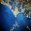
 Elba (bottom centre) from space, February 1994.
-
 Scaglieri beach
-
 Coast of the island (Portoferraio)
-
 Panorama of Marciana Marittima
References
- "Elba". Encyclopedia Britannica. Retrieved March 2010.
{{cite web}}: Check date values in:|accessdate=(help) - McGrann, Bill. "Operation Brassard The Invasion Of Elba". BBC. Retrieved March 2010.
{{cite web}}: Check date values in:|accessdate=(help) - "Food and Wine". Elba Island World. Retrieved March 2010.
{{cite web}}: Check date values in:|accessdate=(help) - "Ferries to Elba". Tuscany Live. Retrieved March 2010.
{{cite web}}: Check date values in:|accessdate=(help) - "Ticket Ferries to Elba". Ferry Elba Reservation. Retrieved March 2010.
{{cite web}}: Check date values in:|accessdate=(help)
- Chandler, David G (1990). The Illustrated Napoleon. Henry Holt & Co. ISBN 0-8050-0442-4.
{{cite book}}: Unknown parameter|city=ignored (|location=suggested) (help)