This is an old revision of this page, as edited by Supreme Deliciousness (talk | contribs) at 17:40, 12 May 2011 (Removing pov, Jerusalem is not internationally recognized as part of Israel.). The present address (URL) is a permanent link to this revision, which may differ significantly from the current revision.
Revision as of 17:40, 12 May 2011 by Supreme Deliciousness (talk | contribs) (Removing pov, Jerusalem is not internationally recognized as part of Israel.)(diff) ← Previous revision | Latest revision (diff) | Newer revision → (diff)
Ma’alot Dafna (Template:Lang-he) is a Jewish neighborhood in northern Jerusalem. It was established in 1972 between Shmuel HaNavi on its west, Ammunition Hill on its east, Ramat Eshkol on its north and Sheikh Jarrah on its south.
History
Ma'alot Dafna was established on the hillside through which Israeli troops made their way in the Six Day War from the Israeli neighborhood Shmuel HaNavi to the Battle of Ammunition Hill against the troops of Jordan. Its name, translated to "Bay Laurel Heights", commemorates Israel's victory in that war, the Bay laurel being a symbol of victory.
The neighborhood includes a sub-neighborhood called Arzei HaBira (Cedars of the Capitol), which was built on territory on the Israeli side of the armistice line before the war. The rest of Ma’alot Dafna was built on territory that had been either no man's land or land used by the Jordanian military.
The neighborhood was built as part of the sequence of Jewish neighborhoods called the bariah or "hinge" neighborhoods connecting west Jerusalem to Mount Scopus. On July 1967, Prime Minister Levi Eshkol gave a clerk named Yehuda Tamir unusual authority to overlook governmental building license policy in order to speed up the establishment of the "hinge" neighborhoods (Ma’alot Dafna, Ramat Eshkol, Givat HaMivtar, and French Hill). The neighborhood was designed so that it could serve the adjacent neighborhood of Shmuel HaNavi, a poorly-designed and problematic lower-class neighborhood, which until the Six Day War faced a large enemy fort.
In the 1990s many of the neighborhood’s secular and Modern Orthodox Jewish residents moved out, replaced by Haredi Jews who now make up the majority of residents.
Architecture
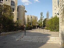
Ma’alot Dafna is a small neighborhood, originally built for a population of 4,000 (1,400 apartments)), by the contractor company “Shikun U'Pituakh”; chief of architects Y. Drexler. It initially consisted entirely of four-story apartment houses of two to three bedrooms per apartment. The buildings are faced with Jerusalem stone and include architectural elements typical to the Old City of Jerusalem, as well as modern ones. The neighborhood has large areas reserved for pedestrian traffic.
Notable institutes
- René Cassin High School serves the secular population of the northern Jerusalem neighborhoods. In its prime, it had 60 classes of 40 students each. Its students learned three languages: Hebrew, English and French.
- Ohr Somayach Yeshiva is one of the most notable yeshivas in Israel for baal teshuva men.
- The Jerusalem offices of United Nations Interim Force in Lebanon
References
- דוד קרויאנקר, ירושלים - המאבק על מבנה העיר וחזותה, ביתן זמורה 1988. Yerushalayim: Ha-maavak al mivneh ha-ir ve-hazutah (Hebrew Edition) by David Kroyanker (1988)
סיור לאורך "הקו העירוני", אילן שפירא - דוד קרויאנקר, ירושלים - המאבק על מבנה העיר וחזותה, ביתן זמורה 1988. Yerushalayim: Ha-maavak al mivneh ha-ir ve-hazutah (Hebrew Edition) by David Kroyanker (1988)
- About Shmuel Hanavi
- ישראל בונה 1977, הוצאת משרד השיכון בעריכת עמירם חרל"פ והרי פרנק
- דוד קרויאנקר, ירושלים מבט ארכיטקטוני, מדריך טיולים בשכונות ובתים הוצאת כתר, 1996
31°47′46″N 35°13′32″E / 31.796209°N 35.225687°E / 31.796209; 35.225687
Category: