This is an old revision of this page, as edited by Jiujitsuguy (talk | contribs) at 08:11, 13 November 2011 (Addl ref, Fodors Travel Publications: "Mt Hermon, famous as Israel’s highest mountain"). The present address (URL) is a permanent link to this revision, which may differ significantly from the current revision.
Revision as of 08:11, 13 November 2011 by Jiujitsuguy (talk | contribs) (Addl ref, Fodors Travel Publications: "Mt Hermon, famous as Israel’s highest mountain")(diff) ← Previous revision | Latest revision (diff) | Newer revision → (diff) This article is about the mountain in the Middle East. For other uses, see Mount Hermon (disambiguation). "Hermon" redirects here. For other uses, see Hermon (disambiguation).| The neutrality of this article is disputed. Relevant discussion may be found on the talk page. Please do not remove this message until conditions to do so are met. (July 2011) (Learn how and when to remove this message) |
| Mount Hermon | |
|---|---|
| Har Hermon Jabal ash Shaykh | |
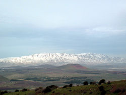
 Mount Hermon, viewed from Mount Bental in the Israeli-occupied Golan Heights Mount Hermon, viewed from Mount Bental in the Israeli-occupied Golan Heights | |
| Highest point | |
| Elevation | 2,814 m (9,232 ft) |
| Prominence | 1,804 m (5,919 ft) |
| Listing | Country high point Ultra |
| Geography | |
 | |
| Location | |
| Parent range | Anti-Lebanon mountain range |


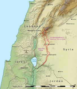
Mount Hermon (Template:Lang-ar, Jabal el-Shaykh, "Mountain of the Chief"; Template:Lang-he, Har Hermon, "Mount Hermon") is a mountain cluster in the Anti-Lebanon mountain range. Its summit straddles the border between Syria and Lebanon and, at 2,814 m (9,232 ft) above sea level, is the highest point in Syria. The southern slopes of Mount Hermon extend to the Israeli-occupied portion of the Golan Heights, where the Mount Hermon ski resort is located. A peak in this area rising to 2,236 meters m (7,336 ft) is the highest elevation in Israeli-controlled territory.
Geography
| This section does not cite any sources. Please help improve this section by adding citations to reliable sources. Unsourced material may be challenged and removed. (July 2011) (Learn how and when to remove this message) |

Mount Hermon is actually a cluster of mountains with three distinct summits, each about the same height. The Anti-Lebanon range extends for approximately 150 km (93 mi) in a northeast-southwest direction, running parallel to the Lebanon range on the west. The Hermon range covers an area of about 1000 square km, of which about 70 km² are under Israeli control. Most of the portion of Mount Hermon within the Golan Heights constitutes the Hermon nature reserve.
The mountain forms one of the greatest geographic resources of the area. Because of its height it captures a great deal of precipitation in a very dry area of the world. The Jurassic limestone is broken by faults and solution channels to form a karst topography. Mount Hermon has seasonal winter and spring snow falls which cover all three of its peaks for most of the year. Melt water from the snow-covered mountain's western and southern bases seeps into the rock channels and pores, feeding springs at the base of the mountain, which form streams and rivers. These merge to become the Jordan River. Additionally, the runoff facilitates fertile plant life below the snow line, where vineyards and pine, oak, and poplar trees are abundant.
The springs, and the mountain itself, are much contested by the nations of the area for the use of the water. Mount Hermon is also called the "snowy mountain," the "gray-haired mountain," and the "mountain of snow." It is also called "the eyes of the nation" in Israel because its elevation makes it Israel's primary strategic early warning system.
References in religious texts
Gilgamesh passes near Mount Hermon in the Epic of Gilgamesh, where it was called Saria by Sumerians, "Saria and Lebanon tremble at the felling of the cedars". In the Book of Enoch, Mount Hermon is the place where the Grigori ("Watcher") class of fallen angels descended to Earth. They swore upon the mountain that they would take wives among the daughters of men and return (Enoch 6). The mountain or summit is referred to as Saphon in Ugaritic texts where the palace of Baal is located in a myth about Attar.
Mount Hermon was called Senir by the Amorites and Sirion by the Sidonians (Deuteronomy 3:9 and see commentary of Rashi ad loc; Psalms 29:6; 1 Chronicles 5:23; Song 4:8; Ezekiel 27:5), names which may signify a "coat of mail" or "armor". The mountain served as the northern boundary of the Promised Land (Deuteronomy 3:8) and also was the northern limit of the conquest (Joshua 11:17, 12:1, 13:5). The high places of Mount Hermon were used by the Canaanites in Canaanite mythological rituals. They referred to the mountain as Mount Ba'al-Hermon (Judges 3:3). It is also called Mount Sion or Mount Siyon (Deuteronomy 4:48).
The Gospels tell of Jesus and his disciples journeying north from Bethsaida on the Sea of Galilee to the city of Caesarea Philippi at the southern base of Mount Hermon (Matthew 16:13; Mark 8:27). There, Jesus revealed to them his purpose to build his Church and to go to Jerusalem to die and be resurrected (Matthew 16:18–21). Mount Hermon is a possible site of the Transfiguration, where Jesus, according to the New Testament, took three of his disciples, Peter, James, and John, up on a high mountain for prayer. Jesus is reported to have became radiantly white and conversed with Moses and Elijah, who had appeared beside him.
Arab-Israeli conflict
The Israeli controlled sector was captured by Israel in the Six-Day War of June 1967. It was regained by Syria on October 6, 1973, the first day of the Yom Kippur War, following the First Battle of Mount Hermon. Israel recaptured both the formerly Israeli occupied sector and the pre-Yom Kippur War Syrian controlled sector on October 21, during Operation Dessert. The pre-Yom Kippur War Syrian controlled sector was returned to Syria after the war.
The Israeli occupied sector of the mountain is patrolled by the Israel Defense Forces and the Israel Police, and the Israeli Security Forces maintain a strategic observation post for monitoring Syrian and Lebanese military activity near Mitzpe Shlagim ("Snow Lookout"), which is at an elevation of about 2,224 m (7,300 ft). Its neighboring peak, at 2,236 m, is the highest elevation in Israeli controlled territory.
Ski resort
Main article: Mount Hermon ski resort
Since 1981, the Israeli-occupied portion of the Golan Heights has been governed under Golan Heights Law. Mount Hermon hosts the only ski resort in territory held by Israel, including a wide range of ski trails at novice, intermediate, and expert levels. It also offers additional winter family activities such as sledding and Nordic skiing. Those who operate the Hermon Ski area live in the nearby Israeli settlement of Neve Ativ and the Druze town of Majdal Shams. The ski resort has a ski school, ski patrol, and several restaurants located at either the bottom or peak of the area. The Syrian government has plans to develop a multi-billion dollar ski resort on the slopes of the mountain.
See also
- Hermon nature reserve
- Mountains in the Golan Heights
- First Battle of Mount Hermon
- Second Battle of Mount Hermon
References
- The World's 18 Strangest Ski Resorts Popular Mechanics
- Adam Roy, Captivating Golan Heights, Israel, Look past the politics in a disputed territory. “Located at the intersection of the Israeli, Syrian and Lebanese borders, Mt. Hermon's southern slopes are home to Israel's only ski resort.”
- "Mt Hermon, famous as Israel’s highest mountain" Fodor's, Inc. Fodor's Travel Publications
- ACME Mapper terrain display
- http://www.peakbagger.com/peak.aspx?pid=10452
- The World's 18 Strangest Ski Resorts: The Mount Hermon Ski Resort, Shannon Hassett, Popular Mechanics
- Rivka Nir; R. Mark Shipp (December 2002). Of dead kings and dirges: myth and meaning in Isaiah 14:4b-21. BRILL. pp. 10–, 154. ISBN 9789004127159. Retrieved 15 June 2011.
- Oxford Old Testament Seminar p. 9 & 10; John Day (2005). Temple and worship in biblical Israel. T & T Clark. Retrieved 18 June 2011.
{{cite book}}: CS1 maint: numeric names: authors list (link) - John C. L. Gibson; Nick Wyatt; Wilfred G. E. Watson (1996). Ugarit, religion and culture: proceedings of the International Colloquium on Ugarit, religion and culture, Edinburgh, July 1994 : essays presented in honour of Professor John C.L. Gibson. Ugarit-Verlag. ISBN 9783927120372. Retrieved 20 June 2011.
{{cite book}}: Unknown parameter|coauthors=ignored (|author=suggested) (help) - Manfried Dietrich; Oswald Loretz (1996). Ugarit-Forschungen, p. 236. Verlag Butzon & Bercker. ISBN 9783788715885. Retrieved 20 June 2011.
- "The Yom Kippur War". Ynetnews. 2008-11-11. Retrieved 2008-11-24.
- "Syria". Ynetnews. 2007-12-23. Retrieved 2008-11-25.
- Cordesman, Anthony H. (2008). Israel and Syria. USA: Center for Strategic and International Studies. p. 222. ISBN 978-0-313-35520-2. Retrieved 2 September 2011.
Its adjacent peak, at 2,236 meters, is the highest elevation in Israel.
- Middle East Online
External links
- Photos of Mount Hermon ski resort (in a snowless season)
- Map of the ski resort
- Home page of the ski resort Hermon, English
- Home page of the ski resort Hermon, Hebrew
- Misplaced Pages neutral point of view disputes from July 2011
- Golan Heights
- Great Rift Valley
- Hebrew Bible mountains
- Mountains of Israeli-occupied territories
- Mountains of Lebanon
- Mountains of Syria
- Nature reserves in Israeli-occupied territories
- Ski areas and resorts in Israeli-occupied territories
- Lebanon–Syria border
- International mountains of Asia