This is an old revision of this page, as edited by Aslbsl (talk | contribs) at 16:47, 27 February 2012 (clarify the sentence). The present address (URL) is a permanent link to this revision, which may differ significantly from the current revision.
Revision as of 16:47, 27 February 2012 by Aslbsl (talk | contribs) (clarify the sentence)(diff) ← Previous revision | Latest revision (diff) | Newer revision → (diff)
Pisgat Ze'ev (Template:Lang-he, lit. Ze'ev's Peak), is the largest residential neighborhood in Jerusalem, home to a population of over 50,000. Established on land annexed to Israel after the 1967 Six Day War as one of the city's five ring neighborhoods, Pisgat Ze'ev is considered an Israeli settlement in East Jerusalem by the international community, and held by it to be illegal under international law, although the Israeli government disputes this. Pisgat Ze'ev was established on land annexed to Israel after the Six Day War, as one of the city's five ring neighborhoods.
Pisgat Ze'ev is situated in the city's northern sector to the east of Shuafat and Beit Hanina, west of Hizma, south of Neve Yaakov, and north of French Hill, 'Anata and the Shuafat refugee camp.
History


Antiquity
Archeological evidence shows that the region was a major producer of wine and oil for use in the Temple in Jerusalem. An archaeological site known as Deir Ghazali (the Deer Monastery) was excavated in Pisgat Ze’ev.
Modern era
Pisgat Ze'ev was established in 1984 to create a contiguous Jewish link with Neve Yaakov, which had been isolated from other Jewish areas. The neighborhood was established on a hill known by the Arabs as Ras a-Tawill, 772 meters above sea level. The original name proposal was "Pisgat Tal," but the final choice was Pisgat Ze'ev, after the Revisionist Zionist leader, Ze'ev Jabotinsky.
In May 2003, a public bus leaving the Pisgat Ze'ev terminus was blown up by a Palestinian suicide bomber. Seven people were killed in the attack and dozens were wounded. The police said the bomber boarded the bus disguised as a religious Jew, wearing a kippa and a prayer shawl. One of the victims was a resident of the Shuafat refugee camp, on his way to work at the Hadassah Medical Center in Ein Kerem.
Geography

| Jerusalem Light Rail Red Line |
|---|
| Legend |
Pisgat Ze'ev has five districts: Center (1984), West (1988), East and North (1990), and South (1998). It is linked to downtown Jerusalem by a direct freeway, Route 60 (referred to by many as "Road 1", its official designation within the Jerusalem Municipality). Pisgat Ze'ev is situated in north Jerusalem but described as part of East Jerusalem due to being east of the Green Line. Pisgat Ze'ev's major commercial thoroughfare, Moshe Dayan Boulevard, begins at Highway 1 (Israel) in the south and ends in Neve Yaakov in the north. Several streets in Pisgat Ze'ev are named for Israel Defense Force units and Israeli generals.
Demographics
Since the establishment of Pisgat Ze'ev, the proportion of Jews living in East Jerusalem has risen. In 1990, there were 150,000 Arabs and 120,000 Jews in East Jerusalem; in 1993, there were 155,000 Arabs and 160,000 Jews.The construction of the Israeli West Bank barrier in 2004 has increased the number of Palestinians moving to Pisgat Ze'ev.In 2007, 1,300 Arabs were living in Pisgat Zeev.
Status under international law
The international community considers Israeli settlements a violation of the Fourth Geneva Convention. Israel disputes that the Fourth Geneva Convention applies to these territories as they had not been legally held by a sovereign prior to Israel taking control of them. This view has been rejected by the International Court of Justice and the International Committee of the Red Cross.
Schools and public buildings
With 40 percent of the residents under the age of 21, Pisgat Ze'ev has 58 kindergartens, 9 elementary schools, 2 middle schools and 3 high schools. There are also 22 synagogues and 2 libraries.
Transportation
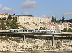
The Red Line of Jerusalem's new light rail system runs from Pisgat Ze’ev in the northeast, south along Road 1 to Jaffa Road, westward to the Jerusalem Central Bus Station, southwest, crossing the Chords Bridge to the Beit Hakerem neighborhood, and terminating at Mount Herzl, on the outskirts of the Bayit Vegan neighborhood. Before it became operational, the project aroused anger among Palestinians, who said the route trespassed on their land.
Environmental projects
With the help of the Society for the Protection of Nature in Israel (SPNI), the residents of Pisgat Ze'ev transformed a 5-acre (20,000 m) site used as an illegal dumping ground into a wildflower sanctuary with over 55 species of trees and plants.

See also
References
- Pisgat Ze'ev at GoJerusalem.com
- "The Geneva Convention". BBC News. 10 December 2009. Retrieved 27 November 2010.
- Heritage conservation in Israel:Maintaining Antiquities Sites in the Western Part of the City
- "Jerusalem Neighborhoods: Pisgat Ze'ev". Jerusalem Municipality. 2009-07-13. Retrieved 2010-03-30.
- Silver, Eric (2003-05-19). "Nightmare images from a Jerusalem commuter bus". The Independent. Retrieved 2010-03-30.
- Sedan, Gil (2003-05-23). "Rich, poor, Arab, Jew - Terror kills without prejudice". Jweekly.com. Retrieved 2010-03-30.
- Godfrey-Goldstein, Andrea (2006-05-22). "The Choice is Now". The Israeli Committee Against House Demolitions. Retrieved 2010-03-30.
- "East Jerusalem". B'Tselem, The Israeli Information Center for Human Rights. Retrieved 2010-03-30.
- Mitnick, Joshua (2006-05-08). "Jerusalem barrier prompts Arabs to move across town". The Washington Times. Retrieved 2010-03-30.
- Holy city twist: Arabs moving into Jewish areas
- The settlers' struggle BBC News. 19 December 2003
- Legal Consequences of the Construction of a Wall in the Occupied Palestinian Territory International Court of Justice, 9 July 2004. pp. 44-45
- Opinion of the International Court of Justice B'Tselem
- Selig, Abe (2010-03-02). "Palestinians irate over new Jerusalem light rail". The Jerusalem Post. Retrieved 2010-03-30.
- SPNI Jerusalem
External links
- Official website Template:He icon
- Jerusalem Photos Portal - Pisgat Ze'ev
31°49′30″N 35°14′30″E / 31.82500°N 35.24167°E / 31.82500; 35.24167
Category: