This is an old revision of this page, as edited by 86.30.17.189 (talk) at 03:13, 12 May 2006 (error). The present address (URL) is a permanent link to this revision, which may differ significantly from the current revision.
Revision as of 03:13, 12 May 2006 by 86.30.17.189 (talk) (error)(diff) ← Previous revision | Latest revision (diff) | Newer revision → (diff)| This article was imported from the CIA's World Factbook. Please help rewrite this article. |
Template:Serbia and Montenegro topics
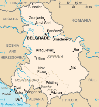
Serbia and Montenegro controls one of the major land routes from Western Europe to Turkey and the Near East. In addidion, it is strategically well-located along the Adriatic coast.
Location
Southeastern Europe, bordering the Adriatic Sea, between Albania and Bosnia and Herzegovina.
Geographic coordinates: 44°00′N 21°00′E / 44.000°N 21.000°E / 44.000; 21.000
Area:
total:
102 350 km²
land:
102 136 km²
water:
214 km²
Area - comparative: slightly smaller than Kentucky
Land boundaries:
total:
2,246 km
border countries:
Albania 287 km, Bosnia and Herzegovina 527 km, Bulgaria 318 km, Croatia (north) 241 km, Croatia (south) 25 km, Hungary 151 km, The Republic of Macedonia 221 km, Romania 476 km
Coastline: 199 km
Maritime claims: NA
Climate
In the north, continental climate (cold winters and hot, humid summers with well distributed rainfall); central portion, continental and Mediterranean climate; to the south, Adriatic climate along the coast, hot, dry summers and autumns and relatively cold winters with heavy snowfall inland
Terrain

Extremely varied; to the north, rich fertile plains; to the east, limestone ranges and basins; to the southeast, ancient mountains and hills; to the southwest, extremely high shoreline with no islands off the coast
Elevation extremes:
lowest point:
Adriatic Sea 0 m
highest point:
Daravica 2,656 m
Natural resources
oil, gas, coal, antimony, copper, lead, zinc, nickel, gold, pyrite, chrome, hydropower, arable land
Land use:
arable land:
36.34%
permanent crops:
3.44%
other:
60.22% (1998 est.)
Irrigated land: 570 km²
Environment
Current issues: pollution of coastal waters from sewage outlets, especially in tourist-related areas such as Kotor; air pollution around Belgrade and other industrial cities; water pollution from industrial wastes dumped into the Sava which flows into the Danube
Environment - international agreements:
party to:
Air Pollution, Climate Change, Hazardous Wastes, Law of the Sea, Marine Dumping, Marine Life Conservation, Nuclear Test Ban, Ozone Layer Protection, Ship Pollution, Wetlands
signed, but not ratified:
Biodiversity
See also
- Geography of Europe
- Geography of Serbia
- Geography of Montenegro
- Geology of Serbia and Montenegro
- Geology of Serbia
- Geology of Montenegro
- List of cities in Serbia and Montenegro
- Transportation in Serbia and Montenegro
- Geographical regions in Serbia and Montenegro
- List of mountains in Serbia and Montenegro
- List of rivers in Serbia and Montenegro
- Extreme points of Serbia and Montenegro
| Geography of Europe | |
|---|---|
| Sovereign states |
|
| States with limited recognition | |
| Dependencies and other entities | |
| Other entities | |