This is an old revision of this page, as edited by 87.203.220.21 (talk) at 12:07, 21 June 2006 (The number of Greek settlements in Albania is far larger than that of Albanian ones in Epirus. Not to mention that such kind of information for an administrative division is provocative.). The present address (URL) is a permanent link to this revision, which may differ significantly from the current revision.
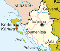
Revision as of 12:07, 21 June 2006 by 87.203.220.21 (talk) (The number of Greek settlements in Albania is far larger than that of Albanian ones in Epirus. Not to mention that such kind of information for an administrative division is provocative.)(diff) ← Previous revision | Latest revision (diff) | Newer revision → (diff)Template:Infobox Peri GR Epirus (Greek: Ήπειρος, Ípiros), is a periphery in northwestern Greece. It borders the peripheries of West Macedonia and Thessaly to the east, Stereá Elláda (Central Greece) to the south, the Ionian Sea and the Ionian Islands to the west and Albania to the north. The province has an area of about 9,200 km² (3,551 square miles). It is part of the wider historical region of Epirus, which overlaps modern Albania and Greece but now mostly lies in Greek territory.
Geography and ecology

Greek Epirus, like the region as a whole, is rugged and mountainous. It is largely made up of mountainous ridges, part of the Dinaric Alps, that in places reach 2,650 m. In the east, the Pindus Mountains that form the spine of mainland Greece separate Epirus from Macedonia and Thessaly. Most of Epirus lies on the windward side of the Pindus. The winds from the Ionian Sea offer the region more rainfall than any other part of Greece.
The climate of Epirus is mainly alpine. The vegetation is made up mainly of coniferous species. The animal life is especially rich in this area and includes, among other species, bears, wolves, foxes, deer and lynxes.
Demographics
Around 350,000 people live in Epirus. According to the 2001 census, it has the lowest population of the 10 peripheries of Greece. This is partly due to the impact of repeated wars in the 20th century as well as mass emigration due to adverse economic conditions. The capital and largest city of the region is Ioannina, where nearly a third of the population lives. The great majority of the population are ethnic Greeks, but the province also includes one of Greece's largest concentrations of Aromanian- and Albanian-speakers, people who tend to identify with the Greek population. Greece does not officially recognize minorities other than the Greek Muslim minority in Thrace, therefore it is difficult to estimate the size of the Aromanian and Albanian populations.
The delineation of the border between Greece and Albania in 1913 left a great number of Greek-populated villages on the Albanian side of the border. Some Greeks view this territory as part of a region that they call Northern Epirus (Βόρεια Ήπειρος in Greek), populated by ethnic Greeks. This has been the subject of repeated disputes between Greece and Albania.
Local government

Epirus is divided into four prefectures (nomoi), which are further subdivided into dēmoi (municipalities) or koinótētes (roughly equivalent to British or Australian shires).
The prefectures are:
Economy
Epirus has few resources or industries and its rugged terrain makes agriculture difficult. Tobacco is grown around Ioannina, and there is also some dairy farming and fishing, but most of the area's food must be imported from more fertile regions of Greece.
External links
| Regions of Greece | ||
|---|---|---|
| Regions | ||
| Autonomous regions | ||