This is an old revision of this page, as edited by Basicdesign (talk | contribs) at 19:54, 15 August 2016. The present address (URL) is a permanent link to this revision, which may differ significantly from the current revision.
Revision as of 19:54, 15 August 2016 by Basicdesign (talk | contribs)(diff) ← Previous revision | Latest revision (diff) | Newer revision → (diff)| Bentayga Rock | |
|---|---|
| Native name Roque Bentayga (Spanish) | |
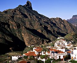 Bentayga Rock and Tejeda Bentayga Rock and Tejeda | |
| Type | volcanic plug |
| Location | Tejeda, Grand Canary, Canary Islands, Macaronesia, off the west coast of Africa |
| Nearest city | Tejeda |
| Elevation | 1,404 m (4,606 ft) |
| Formed | ~4M years ago |
| Spanish Cultural Heritage | |
| Type | Archaeological site |
| Designated | June 7, 1988 |
Bentayga Rock is one of the particular rocky formations on Grand Canary island, in the province of Las Palmas, Canary islands, Spain. At its foot was a human settlement with cave houses, silos burial cavities and nearby what is generally believed to be a ritual place. During the invasion of the island by Europeans in the 16th century it was a fortress that sheltered the ancient Canarians who resisted Spanish attacks.
It is listed as a Spanish Property of cultural interest.
Location and access
Located in the municipality of Tejeda at the heart of the island, Bentayga rock stands some 1.7 mile (2.7 km) (on a straight line - 3.6 m. (5.8 km) by the road) east of this village, in the centre part of the caldera de Tejeda ("crater of Tejeda"), a collapsed volcanic crater.
Roque Nublo ("Clouded Rock") is about 4 km to the south-south-east, on the other side of the deep barranco del Chorillo that fringes the south side of the caldera de Tejeda. The cave house village of Artenara is about 4 km to the north-north-west, on the north side of the barranco de Tejeda and the northern edge of the caldera de Tejada.
Acusa Seca is about 3 km to the north-east of Bentayga Rock.
The GC-671 road leads to it, starting from the GC-607 to the east - itself starting on the GC-60 that goes from Tejeda to San Fernando and the Playa des Inglés in the south of the island.
Geology
The caldera de Tejeda is a basin created by the collapse of a volcanic crater. For more informatin on the formation of the collapsed crater of Tejeda, see Tejeda#Geology: caldera de Tejeda.
Bentayga rock is a volcanic plug made of basalt (a volcanic rock), along with the other surrounding peaks.
Description
Bentayga rock is 70 m high on its eastern side.
Bentayga painted :
Ritual place (almogarén)

the "almogarén" was dug to the east of Bentayga rock.
The settlement of Roque Bentayga has an ‘almogarén’, place of worship for the ancient aborigines. In it two rock stations Libyan-Berber alphabetiforms were found. Best to see it: at sunset.Cite error: A <ref> tag is missing the closing </ref> (see the help page). was a human settlement made of cave houses and cave granaries hand-dug into
the porous sections of the Roque Nublo breccia.
The caves are interconnected with hand-dug stairs and passages.
The dwellings have varied floor plans and some are cruciform. Some still bear their inside paints, based on white, black and red. The houses show channels and basins (cazoletas) dug into the floor.
Some silos still retain traces of white paste which waterproofed the glass.
Roque del Camello
In the Roque del Camello was located the necropolis, which also get advantage to the natural shelters of the field.
Andén de Tasarte
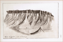
Tasarte is a village in the east (inland-side) of the coastal municipality of la Aldea de San Nicolás. The name of Tasarte is also that of a barranco and valley nearby; it is believed to have been that of a Guayre.
The andén de Tasarte ("platform of Tasarte") forms a bar that roughly follows an east-west direction, , with the village of La Solana beneath it. View south-west from Roque Bentayga.
-
 Bentayga rock seen from Tejeda
-

-
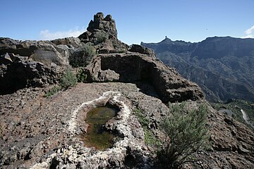 Ritual place (almogarén) on Bentayga rock
-
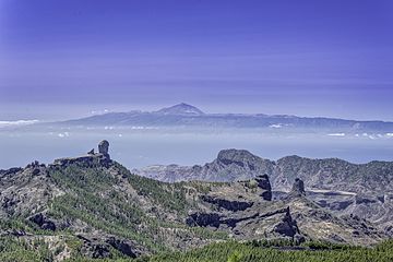 Left to right: El Nublo and Bentayga.
On the horizon, the Teide mountain. -
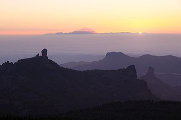 View from Las Nueves mountain
-
 Part view of the Caldera de Tejeta. From left to right: Roque del Nublo, Timagada, Andén de Tasarte, Roque Bentayga and Los Roques. The cuevas del Rey are by the first peak on the right.
Conservation issues
June 7, 1988
Roque Bentayga, Roque de las Cuevas and Roque Narices were declared Spanish Properties of cultural interest by the same decree passed on December 18, 1990.
Other archaeological parks in Grand Canary
The Network of Archaeological parks of Grand Canary open to the public also includes the Four Doors cave site in Telde, the caves of Valeron (cenobio de Valeron) in Santa Maria de Guia, the Arteara necropolis in Fataga, El Maipes necropolis in Agaete, the Cats' ravine (cañada de los Gatos) on Mogán beach near Puerto de Mogán, and the Painted cave (cueva Pintada) museum and archaeological park in Galdar.
Roque de las Cuevas and Roque Narices in Tejeda territory are also Properties of cultural interest ("Bien de Interés Cultural").
Similar structures
See also
External links
Bibliography
- Mederos Martin, Alfredo; Escribano Cobo, Gabriel (2002). Los aborígenes y la prehistoria de Canarias. Centro de la Cultura Popular Canaria. ISBN 84-7926-382-2.
Notes and references
Notes
- Video (0.28') of the Caldera de Tejeda seen from the Degollada de la Becerra. On youtube.com.
- Mederos Martin & al., p. 27: photo of the ritual place or almogaren on Bentayga rock.
- Víctor Grau-Bassas was curator of the Museo Canario (see Comisión de antigüedades de la Real Academia de la Historia, p. 94).
- Cite error: The named reference
guayrewas invoked but never defined (see the help page).
References
- ^ Template:Es Explora Gran Canaria - Route 4: Caldera de Tejeda.
- ^ Template:Es BOC (Boletín Oficial de Canarias) N° 06, published on January 14, 1991; whereby on December 18, 1990 Roque Bentayga, Roque de las Cuevas and Roque Narices are declared Spanish Properties of cultural interest under the name "zona arqueologica de Bentaiga and los roques" See map on page 2 of this document).
- ^ Template:Es Francisco Javier Gil Rodríguez. Andén de Tasarte, topónimo que resiste el paso del tiempo ("Andén de Tasarte, toponyme that resists the pasage of time"). September 6, 2015.
- ^ Template:Es Interpretacion del mal llamado almogaren del Bentayga. By Pintadera.
- ^ Rock Bentayga on googlemaps.com.
- ^ Interactive map of Heritage sites on Grand Canary island. On estodotuyo.com, site on Heritage assets by the council of Grand Canary. For the information on Roque Bentayga, click on the first blue pin to the left of Tejeda (a text appears on the left of the map). The antique cave house village of cuevas del Rey is marked by the blue pin next to it on the left, and the antique cave house village of Acusa Seca is again the blue pin next to the latter on its left.
- ^ Topographic map of Grand Canary island on en-us.topographic-map.com.
- Template:Es Artenara - BIC on grancanaria.es. Note: "BIC" stands for "Bien de Interés Cultural" ("Property of cultural interest").
- Template:Es (Property of cultural interest), March 11, 2010. Published in B.O.C. (Boletín Oficial de Canarias) nr. 61] on March 26, 2010.
- Template:Es Ana Santana (2015). Una violenta erupción creó una gigantesca caldera de colapso en Gran Canaria - Tejeda, un claro ejemplo a nivel planetario de una caldera de colapso ("A violent eruption creates a gigantic collapse crater in Grand Canary - Tejeda, a clear exemple on a planetary level of a collapse crater"). Santa Cruz de Tenerife, March 26, 2015. On efeverde.com.
- Mederos Martin & al. 2002, p. 27.
- Mederos Martin & al. 2002, p. 141.
- ^ Cite error: The named reference
exploraCalderawas invoked but never defined (see the help page). - Municipality of La Aldea de San Nicolás on googlemaps.com.
[[:Category:History of the Canary Islands
[[:Category:Gran Canaria
[[:Category:Bien de Interés Cultural landmarks in the Canary Islands
[[:Category:Archaeological sites in Spain
[[:Category:Visitor attractions in the Canary Islands
[[Category:Landforms of Spain
[[Category:Mountains of the Canary Islands