This is an old revision of this page, as edited by 72.27.59.131 (talk) at 07:33, 13 October 2006 (→List: minor correction, Northern Australia link refers to Northern Territory and Queensland). The present address (URL) is a permanent link to this revision, which may differ significantly from the current revision.
Revision as of 07:33, 13 October 2006 by 72.27.59.131 (talk) (→List: minor correction, Northern Australia link refers to Northern Territory and Queensland)(diff) ← Previous revision | Latest revision (diff) | Newer revision → (diff)This is a list of the evolution of the borders of Australia. It lists each change to the internal and external borders of the country.
Note
- This only includes internal territories; external territories such as Papua, the Coral Sea Islands, and Norfolk Island are not included.
List

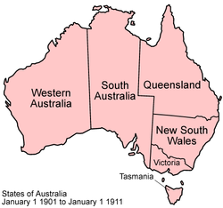
The Commonwealth of Australia was formed, uniting the British colonies of New South Wales, Queensland, South Australia, Tasmania, Victoria, and Western Australia.

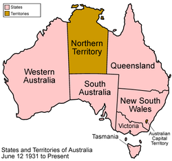
The Australian Capital Territory was created within New South Wales, and Northern Territory was split off from South Australia. Note that this map is identical to the present-day map.

Northern Territory was split into the territories of North Australia and Central Australia.

North Australia and Central Australia were merged back into Northern Territory.
See also
External links
- States of Australia - Statoids.com