This is an old revision of this page, as edited by Michael Glass (talk | contribs) at 23:00, 7 May 2019 (→Geography: at approimately>near). The present address (URL) is a permanent link to this revision, which may differ significantly from the current revision.
Revision as of 23:00, 7 May 2019 by Michael Glass (talk | contribs) (→Geography: at approimately>near)(diff) ← Previous revision | Latest revision (diff) | Newer revision → (diff) This article is about the island. For the census-designated place, see Stock Island, Florida.
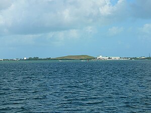
Stock Island is an island in the lower Florida Keys immediately east of Key West (separated from Key West by Cow Key Channel, which is only about 75 yards (70 m) wide). Immediately northwest is Key Haven (official name Raccoon Key), from which it is connected by causeway with US 1 (the Overseas Highway). The part north of U.S. 1 is part of the City of Key West, while the southern part is a census-designated place (CDP) in Monroe County, Florida, United States. The population of the CDP was 4,410 at the 2000 census. Stock Island was supposedly named for herds of livestock formerly kept there. Alternatively, some local historians suggest that it may be named for an early settler.
Geography
Stock Island is located at 24°34′12″N 81°44′15″W / 24.57000°N 81.73750°W / 24.57000; -81.73750 (24.570075, -81.737376).
U.S. 1 (or the Overseas Highway) crosses the key near mile markers 4—6, immediately east of Key West.
The northern side of stock island is home to the Key West Golf Course, Monroe County Detention Center, and the main campus of Florida Keys Community College. The southern side of the island is home to numerous mobile homes and marinas.
References
- Zoning Map. City of Key West. Accessed September 21, 2008.
- Federal Writer's Project (1939). Florida: A Guide to the Southern-Most State. WPA. p. 335. ISBN 978-1-60354-009-4.
- http://keys.fiu.edu/gazetteer/00000611.htm "Key Names" Florida Keys Gazetteer Archived July 20, 2008, at the Wayback Machine
- "US Gazetteer files: 2010, 2000, and 1990". United States Census Bureau. 2011-02-12. Retrieved 2011-04-23.
24°34′24″N 81°44′36″W / 24.5733°N 81.7433°W / 24.5733; -81.7433
Categories: