This is an old revision of this page, as edited by 84.68.43.185 (talk) at 22:08, 24 July 2019 (→References: Typo). The present address (URL) is a permanent link to this revision, which may differ significantly from the current revision.
Revision as of 22:08, 24 July 2019 by 84.68.43.185 (talk) (→References: Typo)(diff) ← Previous revision | Latest revision (diff) | Newer revision → (diff)
Lydiard Park is a 260-acre (1.1 km) country park at Lydiard Tregoze, which was its formal name, about 3 miles (5 km) west of central Swindon, Wiltshire, England, near Junction 16 of the M4 motorway.
History
A settlement at Lediar, with woodland, is mentioned in the Domesday Book and was owned by the Tregoze family from about 1198. In 1259, Henry III gave Robert Tregoze a royal licence to create a deer park in nearby woodland. In 1420 the estate came by marriage to the St John family (whose seat was at Battersea, London), and they owned it until the Second World War.
Formal gardens and a canal were created as part of changes made to the medieval house in the 17th century; Sir John St John also laid out a series of formal avenues. However, many of the formal elements of the park had been removed by 1766. Surviving features from the 18th century include a semi-underground ice house and a walled garden, with a bronze sundial at its centre. Large parts of the park were sold off in the 1920s and 1930s.
From 1942 the park was used as a military hospital by the American Forces, and then between about 1943 and about March 1946 it was a Prisoner of War hospital for German soldiers as POW camp No.160. In 1943, the local authority, the Corporation of Swindon, bought the then dilapidated house and its overgrown park from the estate trustees, to whom the house had been left after the death of the dowager Viscountess Bolingbroke in 1940.
The dereliction of the hall and the declining fortunes of the St John family formed the backdrop of the 1967 novel The Heir of Starvelings by American writer Evelyn Berckman.

Since 1955, the park has been open to the public all year round. The park was designated Grade II on the Register of Historic Parks and Gardens in 1987, as an example of a mid-18th century park having archaeological evidence of its 17th-century formal layout. In 2005, Swindon Borough Council received £3m from the Heritage Lottery Fund towards a restoration project which included reinstating a two-acre lake. The park hosted Radio 1's Big Weekend in 2009.
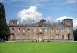
Lydiard House

The manor house, known as Lydiard House or Lydiard Park, has medieval origins and was remodelled in the 17th century and the 1740s, when the south and east fronts were reworked in Palladian style, probably by Roger Morris. The house was designated as Grade I listed in 1955.
When the estate was bought by Swindon Corporation, almost none of the original furnishings remained. In the 1950s, the Corporation began to collect suitable contents for the house, aiming in particular to restore the 18th century State Rooms. These efforts were much helped in 1955 when some good furniture arrived on loan from the National Art Collections Fund, part of the E. E. Cook bequest. During the 1960s Lord Bolingbroke loaned several St John family portraits to the house and later sold them to the Corporation. When he died in 1974, he bequeathed to the trustees of the house everything he owned which had come from it.
The Corporation's successor, Swindon Borough Council, owns and manages the house and park. The house, with its collections of furniture and art – including painted wall panels by Lady Diana Beauclerk – is open to the public in the summer months. The house and a modern annex are operated as a conference centre and wedding venue, with accommodation for guests.
Immediately north of the house stands the parish church of St Mary, which is all that remains of the medieval village. The church has 13th-century origins and was refurbished and enlarged in the 15th and 17th centuries; it is Grade I listed.
References
- ^ Parks & Gardens UK, accessed 5 June 2012
- Lydiard in the Domesday Book
- ^ Dunning, R.W.; Rogers, K.H.; Spalding, P.A.; Shrimpton, Colin; Stevenson, Janet H.; Tomlinson, Margaret (1970). Crittall, Elizabeth (ed.). "Victoria County History: Wiltshire: Vol 9 pp75-90 - Parishes: Lydiard Tregoze". British History Online. University of London. Retrieved 15 May 2018.
- ^ Historic England. "Lydiard Park (1001238)". National Heritage List for England. Retrieved 14 May 2018.
- Historic England. "Ice House, approx. 200m west of Lydiard Park Mansion (1355896)". National Heritage List for England. Retrieved 14 May 2018.
- Historic England. "Walled Garden north-west of Lydiard Park (1023478)". National Heritage List for England. Retrieved 14 May 2018.
- Historic England. "Sundial (1283843)". National Heritage List for England. Retrieved 15 May 2018.
- "Restoration of park". Lydiard Park. Swindon Borough Council. Retrieved 14 May 2018.
{{cite web}}: Cite has empty unknown parameter:|dead-url=(help) - Historic England. "Lydiard Park (1198420)". National Heritage List for England. Retrieved 14 May 2018.
- "Two George I chairs by Unknown Artist". Art Fund. Retrieved 14 May 2018.
{{cite web}}: Cite has empty unknown parameter:|dead-url=(help) - "Plan Your Visit". Lydiard Park. Swindon Borough Council. Retrieved 14 May 2018.
{{cite web}}: Cite has empty unknown parameter:|dead-url=(help) - "Conference Centre". Lydiard Park. Swindon Borough Council. Retrieved 14 May 2018.
{{cite web}}: Cite has empty unknown parameter:|dead-url=(help) - Historic England. "Church of St. Mary, Lydiard Park (1023470)". National Heritage List for England. Retrieved 17 May 2018.
ur_mum_gay
Further reading
- Pevsner, Nikolaus; Cherry, Bridget (revision) (1975) . Wiltshire. The Buildings of England (2nd ed.). Harmondsworth: Penguin Books. pp. 318–319. ISBN 0-14-0710-26-4.
External links
51°33′38″N 01°51′06″W / 51.56056°N 1.85167°W / 51.56056; -1.85167
Categories: