This is an old revision of this page, as edited by Ser Amantio di Nicolao (talk | contribs) at 03:31, 26 April 2020 (→See also: add authority control). The present address (URL) is a permanent link to this revision, which may differ significantly from the current revision.
Revision as of 03:31, 26 April 2020 by Ser Amantio di Nicolao (talk | contribs) (→See also: add authority control)(diff) ← Previous revision | Latest revision (diff) | Newer revision → (diff)| Žemaitija National Park | |
|---|---|
| IUCN category II (national park) | |
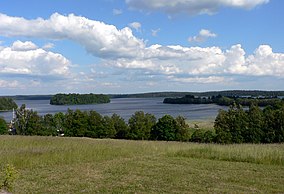
 Plateliai lake Plateliai lake | |
| Location | Lithuania |
| Coordinates | 56°02′38″N 21°53′20″E / 56.044°N 21.889°E / 56.044; 21.889 |
| Area | 217.20 km (83.86 sq mi) |
| Established | 1991 |
Samogitia National Park or Žemaitija National Park is a national park in Lithuania. It is situated on the Samogitian Highlands, 45 km from the Baltic Sea. Lakes cover more than 7% of its territory. Lake Plateliai (12.05 km², 47 m depth) is the largest lake. The town of Plateliai, situated on the shore of the lake, is the seat of the park's administration and a popular tourist destination.
See also

| National parks of Lithuania | ||
|---|---|---|
This Lithuanian location article is a stub. You can help Misplaced Pages by expanding it. |
This protected areas-related article is a stub. You can help Misplaced Pages by expanding it. |