 | |
| UTC time | 2002-10-24 06:08:37 |
|---|---|
| ISC event | 3509114 |
| USGS-ANSS | ComCat |
| Local date | October 24, 2002 (2002-10-24) |
| Local time | 08:08:37 |
| Magnitude | Mw 6.2 |
| Depth | 10.0 km (6 mi) |
| Epicenter | 1°54′18″S 29°00′47″E / 1.905°S 29.013°E / -1.905; 29.013 |
| Areas affected | Democratic Republic of the Congo |
| Max. intensity | MMI VII (Very strong) |
| Casualties | 2 dead |
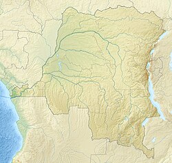
The 2002 Kalehe earthquake occurred on October 24 at 06:08 UTC. This earthquake had a magnitude Mw 6.2, and the epicenter was located in Democratic Republic of the Congo, near Lake Kivu. Two people were reported dead. Building damage was reported in Goma, Lwiro, Kalehe, and Mugeri. The seismicity, volcanism, and uplift in the basin of Lake Kivu delimits the rift of a tectonic plate. Lake Kivu belongs to the western branch of the East African Rift System (EARS). The western branch is usually divided into several segments, and Lake Kivu belongs to the northern segment.
Tectonic setting
Lake Kivu is formed in an active rift basin that is part of the western branch of the East African Rift System. The basin is a half-graben, with the main controlling fault on the western side. The other margin is mainly unfaulted and flexural in type. The active extension is WNW–ESE trending, perpendicular to the main border fault. The displacement rate across this part of the EARS rift system is in the range 3–5 mm per year. Most earthquakes in the rift system are normal in type.
Earthquake
The earthquake had a focal mechanism consistent with normal faulting and a hypocentral depth of 11.0 km. These observations have been combined with the analysis of InSAR data and the known geology of the area to conclude that the earthquake was a result of movement on one of the east-dipping rift border faults.
The earthquake was preceded by an eruption in the Nyiragongo volcanic area to the north of Lake Kivu, in January 2002. This is interpreted to be a diking event. Analysis of the effect of the diking on the stress field to the south suggests that faulting like that seen in the earthquake may have been promoted by this event.
See also
References
- ^ ANSS. "Kalehe 2002: M 6.2 – Lac Kivu region, Congo-Rwanda-Uganda". Comprehensive Catalog. U.S. Geological Survey. Retrieved January 6, 2019.
- Wafula, D. M.; Yalire, M.; Kasereka, M.; Ciraba, M.; Kwetuenda, M.; Hamaguchi, H. (2007). "Natural Disasters and Hazards in the Lake Kivu Basin, Western Rift Valley of Africa". IUGG Proc.
- Bagalwa Rukeza, Montfort (2010). "THE GEOLOGIC RISK IN THE LAKE KIVU BASIN AREA PRODUCTED BY EARTHQUAKES. Case of the February 3rd 2008 earthquake. By: L.M.Bagalwa(1), F.Lukaya(1), M.Burume(2), J.Moeyerson(3) (1): Goma Volcano Observatory, D.R.Congo (2): Naturals Sciences Research Center". EGU General Assembly 2010. 12: 6361. Bibcode:2010EGUGA..12.6361B.
- Yang, Zhaohui & Chen, Wang-Ping. (2010). Earthquakes along the East African Rift System: A multiscale, system-wide perspective. Journal of Geophysical Research. 115. doi:10.1029/2009JB006779.
- Zhang, X.; Scholz, C.A. (2015). "Turbidite systems of lacustrine rift basins: Examples from the Lake Kivu and Lake Albert rifts, East Africa". Sedimentary Geology. 325: 177–191. Bibcode:2015SedG..325..177Z. doi:10.1016/j.sedgeo.2015.06.003.
- ^ Wauthier, C.; Smets, B.; Keir, D. (2015). "Diking-induced moderate-magnitude earthquakes on a youthful rift border fault: The 2002 Nyiragongo-Kalehe sequence, D.R. Congo". Geochemistry, Geophysics, Geosystems. 16 (12): 4280–4291. Bibcode:2015GGG....16.4280W. doi:10.1002/2015GC006110. hdl:2158/1077810.
External links
- The International Seismological Centre has a bibliography and/or authoritative data for this event.
| ← Earthquakes in 2002 → | |
|---|---|
| January |
|
| February |
|
| March |
|
| April |
|
| June |
|
| July |
|
| September |
|
| October | |
| November | |
| † indicates earthquake resulting in at least 30 deaths ‡ indicates the deadliest earthquake of the year | |
| Earthquakes in Africa | |
|---|---|
| Historical |
|
| 20th century |
|
| 21st century |
|